 Jefferys 1770 SD69NE

|

|
|
|
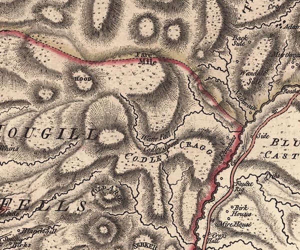
gazetteer links places may or may not be labelled on the map |
||

|
-- Backside Beck |
|
|
|
-- Birks Farm -- "Birk Houses" |
|
|
|
-- Calders -- "COLD ARSE" |
|
|
|
-- Calf, The -- "HOOD" |
|
|
|
-- Cautley Crag -- "CODLEY CRAGG" |
|
|
|
-- Cautley Holme Beck |
|
|
|
-- Cautley Spout -- "Water Fall / Codley Spout" |
|
|
|
-- Cautley Thwaite -- "Thwaites" |
|
|
|
-- Ecker Secker Beck |
|
|
|
-- Foxhole Rigg -- "Faucet Rig" |
|
|
|
-- Howgill Fells-- Howgill Fells -- "HOUGILL FELLS" |
|
|
|
-- Middle Tongue |
|
|
|
-- Mire House -- "Mire House" |
|
|
|
-- Mountain View -- "Back Side" |
|
|
|
-- Rawthey, River -- "Roatha R." |
|
|
|
-- Sedbergh to Kirkby Stephen |
|
|
|
-- Yarlside -- "Fare Mile" |
|
|
civil parishes The area roughly includes parts of parishes:- Orton S Ravenstonedale Sedbergh |
||
|
|
||
|
|
Lakes Guides menu. | |