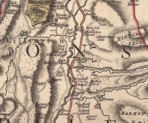
 Jefferys 1770 SD68NW

|

|
|
|
gazetteer links places may or may not be labelled on the map |
||

|
-- Abbey Beck |
|
|
|
-- All Saints Church |
|
|
|
-- Bald Busk -- "Bald Busk" |
|
|
|
-- Beck House -- "Beck House" |
|
|
|
-- Beck Side Farm -- "Beck Side" |
|
|
|
-- Beckside Hall -- "Beck Side" |
|
|
|
-- Beckside -- "Beck Side" |
|
|
|
-- Drybeck -- "Dry Beck" |
|
|
|
-- Egholme Farm -- "Higgin Hall" |
|
|
|
-- Egholme (?) -- "Higgin" |
|
|
|
-- Fellside -- "Fell Side" |
|
|
|
-- Grimes Hill -- "Grimeshill / Moor Esq." |
|
|
|
-- Hall Beck |
|
|
|
-- Hallbeck -- "Hall Beck" |
|
|
|
-- Harprigg -- "Harprigg" |
|
|
|
-- Hawking Hall -- "Hougin Hall" |
|
|
|
-- Heights -- "Hight" |
|
|
|
-- High Hallbeck -- "Hall Beck" |
|
|
|
-- High Stangerthwaite barn -- "Hall Beck" |
|
|
|
-- Holy Ghost Church -- "Chapel" |
|
|
|
-- Killington Bridge |
|
|
|
-- Killington Hall -- "Hall" |
|
|
|
-- Killington -- "Killington" |
|
|
|
-- Light Oaks -- "Yolk of Eggs" |
|
|
|
-- Low Fellside -- "Fell Side" |
|
|
|
-- Low Hallbeck -- "Hall Beck" |
|
|
|
-- Low Stangerthwaite -- "Hall Beck" |
|
|
|
-- Low Stockdale Bridge |
|
|
|
-- Lune, River -- "Lune River" |
|
|
|
-- Middleton Hall -- "Middleton Hall" |
|
|
|
-- Middleton Head -- "Middleton Head" |
|
|
|
-- Middleton Mill -- "Mill" |
|
|
|
-- Middleton -- "Middleton" |
|
|
|
-- Mill House -- "Mill Houses" |
|
|
|
-- Millhouse Beck |
|
|
|
-- Mire Syke -- "Mire Syke" |
|
|
|
-- Old Park -- "KILLINGTON PARK" |
|
|
|
-- Park Hill |
|
|
|
-- Raismoor Side -- "Raisemoor Side" |
|
|
|
-- Rigmaden Park -- "Rigmaiden Hall" |
|
|
|
-- Kirkby Lonsdale to Sedbergh -- "F. S to K. 11.2" |
|
|
|
-- Killington road |
|
|
|
-- Stockdale Beck |
|
|
|
-- Three Mile House -- "Three Mile H." |
|
|
|
-- toll gate, Middleton -- "Toll Gate" |
|
|
|
-- Ullathorns -- "Hollow Thorn" |
|
|
civil parishes The area roughly includes parts of parishes:- Killington Mansergh Middleton Sedbergh Dent |
||
|
|
||
|
|
Lakes Guides menu. | |