 Jefferys 1770 SD67NW

|

|
|
|
gazetteer links places may or may not be labelled on the map |
||

|
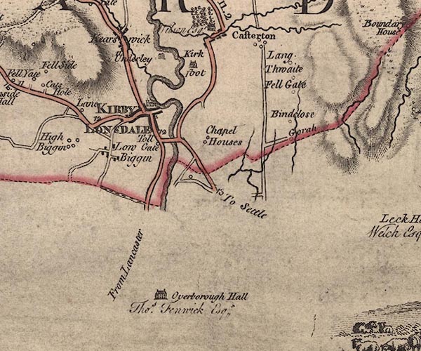
-- Bindloss Farm -- "Bindclose" |
|
|
|
-- Burrow Hall -- "Overborough Hall / Thos. Fenwick
Esqr." |
|
|
|
-- Casterton -- "Casterton" |
|
|
|
-- Chapel House -- "Chapel Houses" |
|
|
|
-- Devil's Bridge |
|
|
|
-- Fell Gate -- "Fell Gate" |
|
|
|
-- Gowrey -- "Gorah" |
|
|
|
-- Kearstwick -- "Kearswick" |
|
|
|
-- Kirfit Hall -- "Kirk foot" |
|
|
|
-- Kirkby Lonsdale -- "KIRBY LONSDALE" |
|
|
|
-- Lane House -- "Lane" |
|
|
|
-- Langthwaite -- "Lang Thwaite" |
|
|
|
-- Low Biggins -- "Low Biggin" |
|
|
|
-- Lune, River -- "Lune River" |
|
|
|
-- Kendal to Kirkby Lonsdale-- Kendal to Kirkby Lonsdale |
|
|
|
-- Kirkby Lonsdale to Sedbergh -- "F. S to K. 11.2" |
|
|
|
-- Kirkby Lonsdale to Settle -- "To Settle" |
|
|
|
-- Lancaster to Kirkby Lonsdale -- "From Lancaster" |
|
|
|
-- Hutton Roof road -- "F. B. to K. 6.[1]" |
|
|
|
-- St Mary's Church |
|
|
|
-- toll gate, Kirkby Lonsdale -- "Toll Gate" |
|
|
|
-- Underley Hall -- "Underlay" |
|
|
civil parishes The area roughly includes parts of parishes:- Kirkby Lonsdale Casterton |
||
|
counties The area includes parts of counties:- Lancashire |
||
|
|
||
|
|
Lakes Guides menu. | |