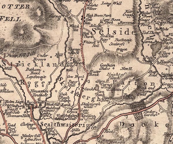
 Jefferys 1770 SD59NW

|

|
|
|
gazetteer links places may or may not be labelled on the map |
||

|
-- Abbey Well -- "Abby Well" |
|
|
|
-- Beetham Bank -- "Betham Bank" |
|
|
|
-- Borwens -- "Barrons" |
|
|
|
-- Bouthwaite -- "Boothwaite" |
|
|
|
-- Bowbank -- "Cow Bank" |
|
|
|
-- Bowston Bridge |
|
|
|
-- Brackenrigg -- "Bracken Rigg" |
|
|
|
-- Burneside Bridge (?) |
|
|
|
-- bridge, Skelsmergh |
|
|
|
-- bridge, Skelsmergh |
|
|
|
-- Burneside Hall -- "Hall" |
|
|
|
-- Burneside Papermill (?) |
|
|
|
-- Burneside -- "Burniside" |
|
|
|
-- Carling Steps -- "Garling Steps" |
|
|
|
-- Crag House -- "Crag H" |
|
|
|
-- Crake Hall -- "Greyca" |
|
|
|
-- Dodding Green -- "Dodding Green" |
|
|
|
-- East Above Park -- "Low Boon Park" |
|
|
|
-- Edge Bank -- "Tarn H." |
|
|
|
-- Garnett Bridge -- "Garnet B." |
|
|
|
-- Garnett Bridge -- "Garnet B." |
|
|
|
-- Garnett Folds -- "Garnet Fould" |
|
|
|
-- Garnett House -- "Garnet H" |
|
|
|
-- Garth Row -- "Garthraw" |
|
|
|
-- Gilpin Bank -- "Gilpin Bank" |
|
|
|
-- Gilthwaiterigg Beck |
|
|
|
-- Gilthwaiterigg -- "Scalthwaiterig Hall" |
|
|
|
-- Goodham Scales -- "Goodham Skales" |
|
|
|
-- Gurnal Bridge |
|
|
|
-- Height of Patton -- "Height of Patton" |
|
|
|
-- High Above Park -- "High Boon Park" |
|
|
|
-- High Thorn -- "High Thorn" |
|
|
|
-- High Underbrow -- "Under Brow" |
|
|
|
-- Hill Farm -- "Hill" |
|
|
|
-- Hill Fold -- "Hill" |
|
|
|
-- Hipshow Farm -- "Hips How" |
|
|
|
-- Holme Lyon -- "Holm Lion" |
|
|
|
-- Kent, River -- "Kent R." -- "Kent R." --
"KENT RIVER" |
|
|
|
-- Ladyford -- "Lady Ford F." |
|
|
|
-- Laithwaite Farm -- "Laythwaite" |
|
|
|
-- Laneside -- "Lane Side" |
|
|
|
-- Laverock Bridge |
|
|
|
-- Littlemire -- "Little Mire" |
|
|
|
-- Low Underbrow -- "Under Brow" |
|
|
|
-- Lowgroves -- "Low Groves" |
|
|
|
-- milestone, Scalthwaiterigg -- "3" |
|
|
|
-- milestone, Skelsmergh -- "3" |
|
|
|
-- milestone, Skelsmergh -- "2" |
|
|
|
-- milestone, Skelsmergh -- "4" |
|
|
|
-- Mill Cottage |
|
|
|
-- Gilthwaiterigg Mill (?) -- "Mill" |
|
|
|
-- Meal Bank Mills (?) |
|
|
|
-- Must Hill -- "Musk Hill" |
|
|
|
-- New House -- "New H." |
|
|
|
-- Oakbank -- "Oak Bank" |
|
|
|
-- Otter Bank -- "Hutter Bank" |
|
|
|
-- Patton Hall Farm -- "Paton Hall" |
|
|
|
-- Potter Fell -- "POTTER FELL / Potter Fell Side" |
|
|
|
-- Redman's Tenement -- "Redmond Tenement" |
|
|
|
-- Kendal to Shap |
|
|
|
-- Kendal to Tebay |
|
|
|
-- Burneside road |
|
|
|
-- Mealbank Road (etc) |
|
|
|
-- Scalthwaiterigg -- "Scalthwaiterigg" |
|
|
|
-- Selside Hall -- "Sellside Hall" |
|
|
|
-- Selside -- "Selside" |
|
|
|
-- Skelsmergh Hall Farm -- "Skelsmergh Hall" |
|
|
|
-- Skelsmergh Tarn |
|
|
|
-- Skelsmergh -- "Skelsmergh" |
|
|
|
-- South Gateside -- "Gate Side" |
|
|
|
-- Sprint Bridge |
|
|
|
-- Sprint, River |
|
|
|
-- St Oswald's Church |
|
|
|
-- St Thomas's Church |
|
|
|
-- Steel Croft -- "Steelcroft" |
|
|
|
-- Stocks Mill -- "Paper Mill" |
|
|
|
-- Stocks -- "Stocks" |
|
|
|
-- Strickland Roger -- "Strickland Roger" |
|
|
|
-- Tarn Bank -- "Tarn Bank" |
|
|
|
-- Tenement Farm -- "Houseman Tenement" |
|
|
|
-- Thornyslack Farm -- "Thorney Slack" |
|
|
|
-- Watchgate -- "Watch Yate" |
|
|
|
-- Whitwell Hall -- "Whitwell Hall" |
|
|
civil parishes The area roughly includes parts of parishes:- Strickland Roger Strickland Ketel Longsleddale Skelsmergh Whitwell and Selside Kendal Scalthwaiterigg Docker Whinfell |
||
|
|
||
|
|
Lakes Guides menu. | |