 Jefferys 1770 SD58SE

|

|
|
|
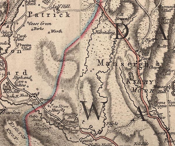
gazetteer links places may or may not be labelled on the map |
||

|
-- Aikbank -- "Oak Bank" |
|
|
|
-- Birks Farm -- "Birks" |
|
|
|
-- Blea Beck |
|
|
|
-- Bleabeck Bridge |
|
|
|
-- Brow Head -- "Cow Brow Head" |
|
|
|
-- Cowbrow Foot -- "Cow Brow Foot" |
|
|
|
-- Fleet -- "Flight" |
|
|
|
-- Greenlane End -- "Green Lane End" |
|
|
|
-- High Fell House -- "Fell Houses" |
|
|
|
-- Hunger Hills |
|
|
|
-- Kirkby Lonsdale Moor -- "KIRBY MOOR" |
|
|
|
-- Kitridding -- "Kitreading" |
|
|
|
-- Low Fell House -- "Fell Houses" |
|
|
|
-- Lupton Hall -- "Lupton Hall" |
|
|
|
-- Lupton Tower -- "B[ox] Tree" |
|
|
|
-- Lupton -- "Lupton" |
|
|
|
-- Mansergh High -- "High" |
|
|
|
-- Mansergh -- "Mansergh" |
|
|
|
-- Middle Fell House -- "Fell Houses" |
|
|
|
-- Newbiggin Farm -- "New [B]iggin" |
|
|
|
-- Newbiggin Old Hall -- "New [B]iggin" |
|
|
|
-- Newbiggin -- "New [B]iggin" |
|
|
|
-- Nook -- "Nook" |
|
|
|
-- Old Town -- "Old Town" |
|
|
|
-- Kendal to Kirkby Lonsdale-- Kendal to Kirkby Lonsdale |
|
|
|
-- Scout Hill |
|
|
|
-- Terrybank Tarn |
|
|
|
-- Thompson Fold -- "Thomson Fould" |
|
|
|
-- Warth -- "Worth" |
|
|
civil parishes The area roughly includes parts of parishes:- Preston Patrick Lupton Mansergh Kirkby Lonsdale Beetham Hutton Roof |
||
|
|
||
|
|
Lakes Guides menu. | |