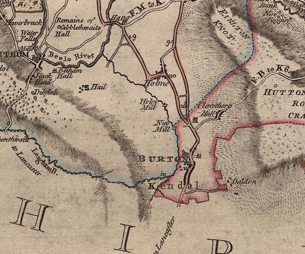
 Jefferys 1770 SD57NW

|

|
|
|
gazetteer links places may or may not be labelled on the map |
||

|
-- Beetham Hall (?) -- "Betham Hall" |
|
|
|
-- Bela, River -- "Beelo River" |
|
|
|
-- Burton House |
|
|
|
-- Burton-in-Kendal -- "BURTON in Kendal" |
|
|
|
-- Cappleside Hall -- "Remains of Cabblethwaite
Hall" |
|
|
|
-- Clawthorpe Hall -- "[Clawthorp] Hall" |
|
|
|
-- Clawthorpe -- "Clawthorp" |
|
|
|
-- Dalton -- "Daldon" |
|
|
|
-- Farleton Fell |
|
|
|
-- Hale -- "Hail" |
|
|
|
-- Heron Syke |
|
|
|
-- Holme Beck |
|
|
|
-- Holme Mills -- "Holm Mill" |
|
|
|
-- Holme -- "Holme" |
|
|
|
-- milestone, Burton-in-Kendal -- "11" |
|
|
|
-- milestone, Holme -- "9" |
|
|
|
-- milestone, Holme -- "10" |
|
|
|
-- milestone, Natland -- "9" |
|
|
|
-- milestone, Natland -- "10" |
|
|
|
-- New Mill -- "New Mill" |
|
|
|
-- Burton-in-Kendal to Milnthorpe |
|
|
|
-- Lancaster to Kendal -- "from Lancaster" |
|
|
|
-- Hutton Roof road -- "F. B. to K. 6.[1]" |
|
|
|
-- St James's Church |
|
|
civil parishes The area roughly includes parts of parishes:- Beetham Holme Burton-in-Kendal Hutton Roof |
||
|
counties The area includes parts of counties:- Lancashire |
||
|
|
||
|
|
Lakes Guides menu. | |