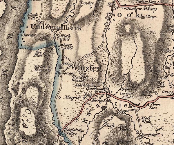
 Jefferys 1770 SD49SW

|

|
|
|
gazetteer links places may or may not be labelled on the map |
||

|
-- Birket Houses -- "Birket Houses" |
|
|
|
-- Blackwell -- "Black Well" |
|
|
|
-- bridge, Crosthwaite |
|
|
|
-- Cartmel Fell -- "CARTMELL FELLS" |
|
|
|
-- Crook -- "Crook" |
|
|
|
-- Crosthwaite Corn Mill |
|
|
|
-- Crosthwaite -- "Crosthwaite" -- "Crosthwaite
Green" |
|
|
|
-- Fell Side -- "Fell Side" |
|
|
|
-- Head of Winster -- "Head of Winster" |
|
|
|
-- High Cartmell Fold -- "Cartmel Fould" |
|
|
|
-- High Farm, The -- "High" |
|
|
|
-- High House Farm -- "Rye Beck" |
|
|
|
-- High Mill House -- "High Mill" |
|
|
|
-- High Mill -- "High Mill" |
|
|
|
-- High Yews -- "Yews" |
|
|
|
-- Hollow Clough Gill |
|
|
|
-- Holy Trinity Church |
|
|
|
-- Howe Farm -- "How" |
|
|
|
-- Low Cartmell Fold -- "Cartmel Fould" |
|
|
|
-- Low Yews -- "Yews" |
|
|
|
-- Mearson's Farm -- "Masons" |
|
|
|
-- Mill House -- "Low Mill" |
|
|
|
-- Mirk Howe -- "Mark How" |
|
|
|
-- Moss Side -- "Moss Side" |
|
|
|
-- Old Vicarage, The -- "Parsonage" |
|
|
|
-- packhorse bridge, Crook |
|
|
|
-- Kendal to Newby Bridge |
|
|
|
-- Sampool Bridge to Windermere -- "F. B. to M. 14
4" |
|
|
|
-- Witherslack road -- "From Cartmell" -- "From
Cartmell" |
|
|
|
-- Spout House -- "Spout" |
|
|
|
-- St Catherine's Church -- "Chap" |
|
|
|
-- St Mary's Church |
|
|
|
-- tarn, Crosthwaite and Lyth |
|
|
|
-- Tarnside -- "Tarn Side" |
|
|
|
-- Undermillbeck -- "Undermillbeck" |
|
|
|
-- Winster -- "Winster" |
|
|
|
-- Yews, The -- "Yews" |
|
|
civil parishes The area roughly includes parts of parishes:- Windermer Cartmel Fell Crook Crosthwaite and Lyth Underbarrow and Bradleyfield |
||
|
|
||
|
|
Lakes Guides menu. | |