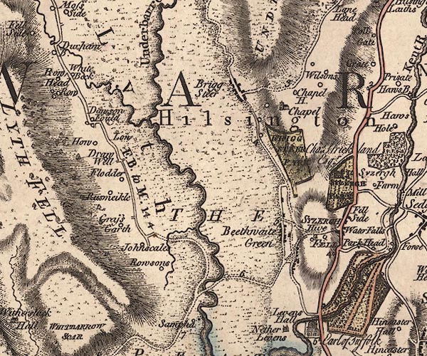
 Jefferys 1770 SD48NE

|

|
|
|
gazetteer links places may or may not be labelled on the map |
||

|
-- Beethwaite Green -- "Beethwaite Green" |
|
|
|
-- Briggs House Farm -- "Wilsons" |
|
|
|
-- Brigsteer Park -- "BRIGG STEER PARK" |
|
|
|
-- Brigsteer -- "Brigg Steer" |
|
|
|
-- Chapel House -- "Chapel H." |
|
|
|
-- Dawson Fold -- "Dawson Fould" |
|
|
|
-- Draw Well -- "Draw Well" |
|
|
|
-- Fell Side Farm -- "Fell Side" |
|
|
|
-- Flodder Hall -- "Flodder" |
|
|
|
-- Grassgarth -- "Grass Garth" |
|
|
|
-- Heaves Farm -- "Hive" |
|
|
|
-- Heaves Hotel -- "Hive" |
|
|
|
-- Helsington -- "Hilsington" |
|
|
|
-- Howe, The -- "How" |
|
|
|
-- Johnscales -- "Johnscales" |
|
|
|
-- Levens Bridge |
|
|
|
-- Levens Moss -- "THE PEAT MOSSES" |
|
|
|
-- Levens Park |
|
|
|
-- Low Farm -- "Low" |
|
|
|
-- Lyth Moss -- "THE PEAT MOSSES" |
|
|
|
-- Lyth Valley -- "Lyth" |
|
|
|
-- milestone, Helsington -- "3" |
|
|
|
-- milestone, Helsington -- "4" |
|
|
|
-- Rawsons -- "Rowsons" |
|
|
|
-- Rawson's Moss -- "THE PEAT MOSSES" |
|
|
|
-- Sampool Bridge to Windermere -- "F. B. to M. 14
4" |
|
|
|
-- Brigsteer Road |
|
|
|
-- Meathop and Ulpha road |
|
|
|
-- Rus Mickle -- "Rusmeikle" |
|
|
|
-- Sampool Bridge |
|
|
|
-- Sizergh Castle -- "SYZERGH PARK / Chas. Strickland
Esqr." |
|
|
|
-- Sizergh Fell -- "SYZERGH FELL" |
|
|
|
-- South Low Farm -- "Low" |
|
|
|
-- St John's Church -- "Chapel" |
|
|
|
-- Underbarrow Beck -- "Underbarrow B." |
|
|
|
-- Underbarrow Pool -- "Underbarrow Beck" |
|
|
|
-- Whitebeck -- "White Beck" |
|
|
civil parishes The area roughly includes parts of parishes:- Crosthwaite and Lyth Underbarrow and Bradleyfield Helsington Levens |
||
|
|
||
|
|
Lakes Guides menu. | |