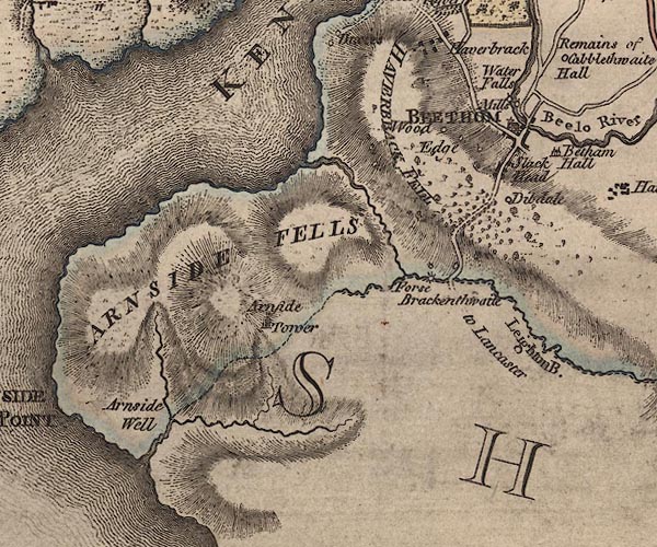
 Jefferys 1770 SD47NE

|

|
|
|
gazetteer links places may or may not be labelled on the map |
||

|
-- Arnside Fell -- "ARNSIDE FELLS" |
|
|
|
-- Arnside Tower -- "Arnside Tower" |
|
|
|
-- Beetham Bridge |
|
|
|
-- Beetham Fell -- "HAVERBRACK FELL" |
|
|
|
-- Beetham -- "BEETHAM" |
|
|
|
-- Bela Falls -- "Water Falls" |
|
|
|
-- Brackenthwaite -- "Brackenthwaite" |
|
|
|
-- Cove Well -- "Arnside Well" |
|
|
|
-- Deepdale Farm -- "Dibdale" |
|
|
|
-- Heron Corn Mill and Museum of Papermaking --
"Mills" |
|
|
|
-- High Wood Edge -- "Wood Edge" |
|
|
|
-- Kent Estuary -- "KENT RIVER" |
|
|
|
-- Leighton Beck Bridge |
|
|
|
-- Leighton Beck -- "Leighton B." |
|
|
|
-- Leighton Furnace -- "Forse" |
|
|
|
-- Low Wood Edge -- "Wood Edge" |
|
|
|
-- Major Woods |
|
|
|
-- Carnforth to Milnthorpe -- "to Lancaster" |
|
|
|
-- Slack Head -- "Slack Head" |
|
|
|
-- St Michael and All Angels Church |
|
|
|
-- Underlaid Wood |
|
|
|
-- Waterhouse Mills -- "Mills" |
|
|
civil parishes The area roughly includes parts of parishes:- Meathop and Ulpha Arnside Beetham |
||
|
counties The area includes parts of counties:- Lancashire |
||
|
|
||
|
|
Lakes Guides menu. | |