 Jefferys 1770 NY81SE

|

|
|
|
gazetteer links places may or may not be labelled on the map |
||

|
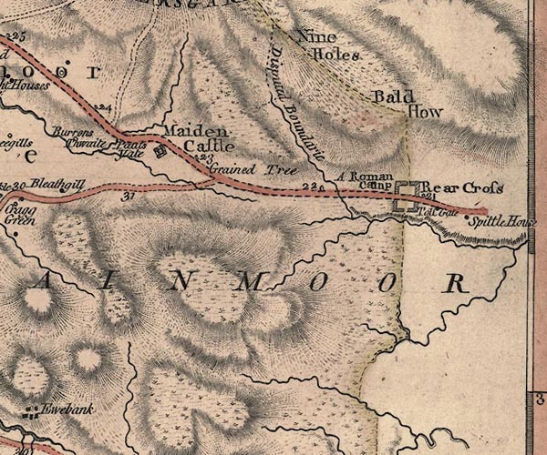
-- Beldoo Hill -- "Bald How" |
|
|
|
-- Blackhause Sike |
|
|
|
-- Grained Tree -- "Grained Tree" |
|
|
|
-- Greta, River |
|
|
|
-- Maiden Castle -- "Maiden Castle" |
|
|
|
-- milestone, Durham -- "21" |
|
|
|
-- milestone, Stainmore -- "24" |
|
|
|
-- milestone, Stainmore -- "23" |
|
|
|
-- milestone, Stainmore -- "22" |
|
|
|
-- Nine Holes -- "Nine Holes" |
|
|
|
-- Old Spital -- "Spittle House" |
|
|
|
-- Palliard -- "Pauls Yate" |
|
|
|
-- Rey Cross -- "Rear Cross" |
|
|
|
-- Bowes to Brough |
|
|
|
-- Kirkby Stephen to Rey Cross |
|
|
|
-- roman fort, Rey Cross -- "A Roman Camp" |
|
|
|
-- Rowtonbridge Sike |
|
|
|
-- Slapestone Sike |
|
|
|
-- Spital Turn Pike -- "Toll Gate" |
|
|
|
-- Stainmore Common -- "STAINMOOR FOREST" |
|
|
|
-- Disputed Ground -- "Disputed Boundarie" |
|
|
|
-- Yard Sike |
|
|
|
-- Yardstone Beck |
|
|
civil parishes The area roughly includes parts of parishes:- Stainmore |
||
|
counties The area includes parts of counties:- Durham |
||
|
|
||
|
|
Lakes Guides menu. | |