 Jefferys 1770 NY71SW

|

|
|
|
gazetteer links places may or may not be labelled on the map |
||

|
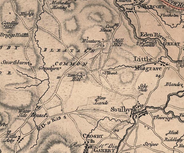
-- Bleatarn Common -- "BLEATARN COMMON" |
|
|
|
-- Bleatarn -- "Bleatarn" |
|
|
|
-- bridge, Waterhouses |
|
|
|
-- Cote House -- "Coat House" |
|
|
|
-- Goosemire Sike |
|
|
|
-- Grassgill Rigg -- "Tewfoot Hill" |
|
|
|
-- High Griseburn -- "Graysburn" |
|
|
|
-- Hull Bank -- "Ulbank" |
|
|
|
-- Low Griseburn -- "Graysburn" |
|
|
|
-- Mill Hill -- "Mill Hill" |
|
|
|
-- Newlands -- "New Lands" |
|
|
|
-- Ploughlands -- "Plough Lands" |
|
|
|
-- Newbiggin-on-Lune to Brough |
|
|
|
-- Orton to Warcop |
|
|
|
-- Soulby road -- "F. O to K 13 4" |
|
|
|
-- Sikeside -- "Syke Side" |
|
|
|
-- Soulby Bridge |
|
|
|
-- Soulby -- "Soulby" |
|
|
|
-- St Luke's Church |
|
|
|
-- Tewfill Hill -- "Tewfoot Hill" |
|
|
|
-- Water Houses -- "Water Side Houses" |
|
|
civil parishes The area roughly includes parts of parishes:- Ormside Warcop Musgrave Asby Souby Crosby Garrett |
||
|
|
||
|
|
Lakes Guides menu. | |