 Jefferys 1770 NY70SE

|

|
|
|
gazetteer links places may or may not be labelled on the map |
||

|
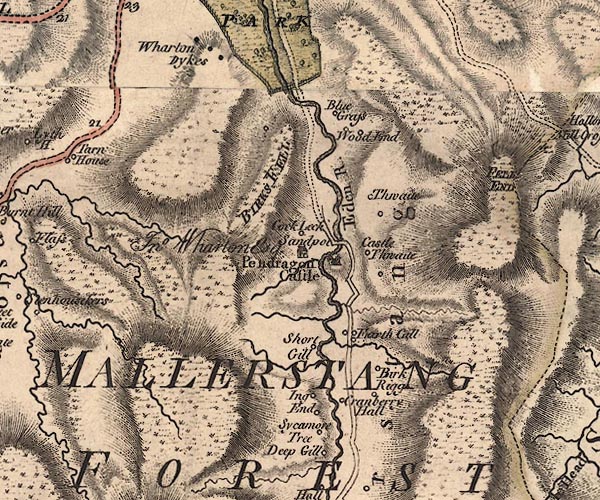
-- Birk Rigg -- "Birk Rigg" |
|
|
|
-- Birkett Common -- "BIRKS FELL" |
|
|
|
-- Carr House -- "Wood End" |
|
|
|
-- Castle Bridge |
|
|
|
-- Castlethwaite -- "Castle Thwaite" |
|
|
|
-- Cranberry -- "Cranberry Hall" |
|
|
|
-- Dalefoot -- "Blue Grays" |
|
|
|
-- Eden, River -- "Eden River" -- "Eden
River" -- "Eden R." |
|
|
|
-- Fallgill Sike |
|
|
|
-- High Cocklake -- "Cock Leck" |
|
|
|
-- Ings Ends -- "Ing End" |
|
|
|
-- Low Cocklake -- "Cock Leck" |
|
|
|
-- Mallerstang Edge |
|
|
|
-- Mallerstang Forest -- "MALLERSTANG FOREST" |
|
|
|
-- Mallerstang -- "Mallerstang" |
|
|
|
-- Outhgill Beck |
|
|
|
-- Outhgill -- "Earth Gill" |
|
|
|
-- Pendragon Castle -- "Pendragon Castle" |
|
|
|
-- Kirkby Stephen to Moorcock -- "to Askrigg" |
|
|
|
-- Sandpot -- "Sandpot / Jno. Wharton Esq." |
|
|
|
-- Shoregill -- "Short Gill" |
|
|
|
-- Southwaite -- "Thwaite" |
|
|
|
-- Sycamore Tree Farm -- "Sycamore Tree" |
|
|
|
-- Wharton Fell -- "BIRKS FELL" |
|
|
civil parishes The area roughly includes parts of parishes:- Ravenstonedale Kirkby Stephen Wharton Mallerstang Nateby |
||
|
|
||
|
|
Lakes Guides menu. | |