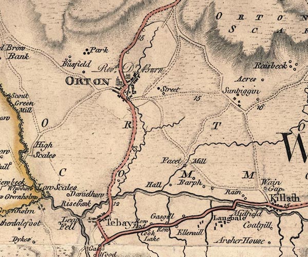
 Jefferys 1770 NY60NW

|

|
|
|
gazetteer links places may or may not be labelled on the map |
||

|
-- All Saints Church |
|
|
|
-- Birk Beck |
|
|
|
-- Bousfield -- "Busfield" |
|
|
|
-- Chapel Beck |
|
|
|
-- Danielhill -- "Danielhow" |
|
|
|
-- Ellergill Beck |
|
|
|
-- Ellergill -- "Elleraill" |
|
|
|
-- Fawcett Mill -- "Facet Mill" |
|
|
|
-- Gaisgill Row -- "Row" |
|
|
|
-- Gaisgill -- "Gasgill" |
|
|
|
-- High Barugh -- "Barph" |
|
|
|
-- Langdale Beck |
|
|
|
-- Longdale -- "Langbale" |
|
|
|
-- Loupsfell Side -- "Leap Fell" |
|
|
|
-- Low Barugh -- "Barph" |
|
|
|
-- Lune, River -- "Lune River" |
|
|
|
-- Midfield -- "Midfield" |
|
|
|
-- Old Tebay -- "Tebay" |
|
|
|
-- Orton Common -- "ORTON COMMON" |
|
|
|
-- Orton Scar -- "ORTON SCAR" |
|
|
|
-- Orton -- "ORTON" |
|
|
|
-- Park -- "Park" |
|
|
|
-- Rais Beck |
|
|
|
-- Raisbank -- "Risebank" |
|
|
|
-- Raisbeck -- "Sunbiggin" |
|
|
|
-- Raisgill Hall -- "Hall" |
|
|
|
-- Rayne Bridge |
|
|
|
-- Rayne -- "Rain" |
|
|
|
-- Orton to Warcop |
|
|
|
-- Shap to Orton -- "F. S to O 6." |
|
|
|
-- Tebay to Appleby |
|
|
|
-- Tebay to Kirkby Stephen |
|
|
|
-- Row End -- "Row Ead" |
|
|
|
-- Street Farm -- "Street" |
|
|
|
-- Street -- "Street" |
|
|
|
-- Tebay Bridge |
|
|
|
-- Tebay Gill |
|
|
|
-- Vicarage, The -- "Revd. Dr. Burn" |
|
|
civil parishes The area roughly includes parts of parishes:- Crosby Ravensworth Asby Orton S Teaby |
||
|
|
||
|
|
Lakes Guides menu. | |