 Jefferys 1770 NY52NW

|

|
|
|
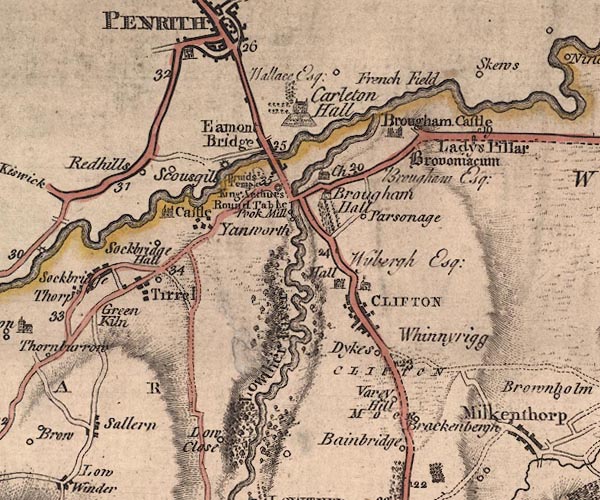
gazetteer links places may or may not be labelled on the map |
||

|
-- Arthur's Round Table -- "King Arthurs Round
Table" |
|
|
|
-- Bainbridge Gate -- "Bainbridge" |
|
|
|
-- Brackenber Hill -- "Brackenberg" |
|
|
|
-- Brougham Castle -- "Brougham Castle" |
|
|
|
-- Brougham Hall -- "Brougham Hall / Brougham Esq;" |
|
|
|
-- Carleton Hall -- "Carleton Hall / Wallace Esq;" |
|
|
|
-- Clifton Hall -- "Hall / Wybergh Esq;" |
|
|
|
-- Clifton Moor -- "CLIFTON MOOR" |
|
|
|
-- Clifton -- "CLIFTON" |
|
|
|
-- Countess Pillar -- "Ladys Pillar" |
|
|
|
-- Eamont Bridge -- "Eamont Bridge" |
|
|
|
-- Eamont Bridge -- "Eamont Bridge" |
|
|
|
-- Eamont, River -- "Emont River" |
|
|
|
-- Frenchfield -- "French Field" |
|
|
|
-- Greenkiln -- "Green Kiln" |
|
|
|
-- Lowclose -- "Low Close" |
|
|
|
-- Lowther, River -- "Lowther River" |
|
|
|
-- Mayburgh -- "Druids Temple" |
|
|
|
-- milestone, Brougham -- "19" |
|
|
|
-- milestone, Brougham -- "20" |
|
|
|
-- milestone, Clifton -- "23" |
|
|
|
-- milestone, Clifton -- "24" |
|
|
|
-- Penrith Castle |
|
|
|
-- Poak Mill -- "Pook Mill" |
|
|
|
-- Rectory Farm -- "Parsonage" |
|
|
|
-- Red Hills -- "Redhills" |
|
|
|
-- Appleby to Penrith |
|
|
|
-- Askham to Penrith |
|
|
|
-- Patterdale to Penrith -- "F. A. to P. 23'4" |
|
|
|
-- Penrith to Keswick -- "From Keswick" |
|
|
|
-- Shap to Penrith |
|
|
|
-- Brocavum -- "Brovoniacum" |
|
|
|
-- Sceugh -- "Skews" |
|
|
|
-- Skirsgill -- "Scousgill" |
|
|
|
-- Sockbridge Hall -- "Sockbridge Hall" |
|
|
|
-- Southwaitegreen Mill |
|
|
|
-- St Cuthbert's Church |
|
|
|
-- St Wilfred's Chapel -- "Ch." |
|
|
|
-- Tirril -- "Tirrel" |
|
|
|
-- Town End -- "Dykes" |
|
|
|
-- Varey Hill -- "Varey Hill" |
|
|
|
-- Whinnyrigg -- "Whinneyrigg" |
|
|
|
-- Yanwath Hall -- "Castle" |
|
|
|
-- Yanwath -- "Yanworth" |
|
|
civil parishes The area roughly includes parts of parishes:- Dacre Penrith Sockbridge and Tirril Yanwath and Eamont Bridge Askham Lowther Brougham Clifton |
||
|
|
||
|
|
Lakes Guides menu. | |