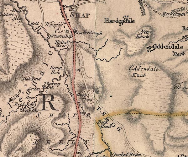
 Jefferys 1770 NY51SE

|

|
|
|
gazetteer links places may or may not be labelled on the map |
||

|
-- Beck Head -- "Beck Head" |
|
|
|
-- Brackenber -- "Brackenbergh / Whinfield Esqr." |
|
|
|
-- bridge, Shap Rural |
|
|
|
-- Docker Beck |
|
|
|
-- Force Beck |
|
|
|
-- Force Bridge |
|
|
|
-- ford, Shap |
|
|
|
-- Green Farm -- "Green" |
|
|
|
-- Hardendale -- "Hardondale" |
|
|
|
-- Keld -- "Keld" |
|
|
|
-- milestone, Shap -- "15" |
|
|
|
-- milestone, Shap -- "14" |
|
|
|
-- milestone, Shap -- "13" |
|
|
|
-- New Intakes -- "New Intack" |
|
|
|
-- Oddendale Nab -- "Oddendale Knab" |
|
|
|
-- Oddendale -- "Oddendale" |
|
|
|
-- Kendal to Shap |
|
|
|
-- Shap to Orton -- "F. S to O 6." |
|
|
|
-- Shap Fells -- "BIRBECK FELLS" -- "SHAPP
FELLS" |
|
|
|
-- Shap Thorn, The -- "Shapp Thorn" |
|
|
|
-- Thorney Bank -- "Thorney Bank" |
|
|
|
-- Thornship -- "Thornship" |
|
|
|
-- Ullsmoor -- "Huls Moor" |
|
|
|
-- Wickers Gill |
|
|
civil parishes The area roughly includes parts of parishes:- Crosby Ravensworth Shap Shap Rural |
||
|
|
||
|
|
Lakes Guides menu. | |