 Jefferys 1770 NY51NW

|

|
|
|
gazetteer links places may or may not be labelled on the map |
||

|
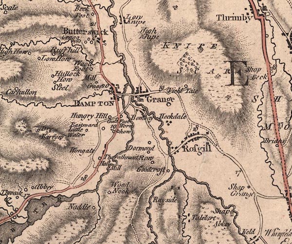
-- Bampton Bridge |
|
|
|
-- Bampton Grange -- "Grange" |
|
|
|
-- Bampton -- "BAMPTON" |
|
|
|
-- Black Bridge |
|
|
|
-- Bomby -- "Bombay" |
|
|
|
-- Butterwick Bridge |
|
|
|
-- Butterwick -- "Butterswick" |
|
|
|
-- Church Bridge |
|
|
|
-- Eastward -- "Eastward" |
|
|
|
-- Field Gate -- "Field Ya[t]e" |
|
|
|
-- Gill Beck |
|
|
|
-- Goodcroft -- "Goodcroft" |
|
|
|
-- Haweswater Beck |
|
|
|
-- Hegdale -- "Heckdale" |
|
|
|
-- High Hullockhowe -- "Hullock How" |
|
|
|
-- High Knipe -- "High Knipe" |
|
|
|
-- Howes Beck |
|
|
|
-- Hungerhill -- "Hungry Hill" |
|
|
|
-- Knipe Scar -- "KNIPE SCAR" |
|
|
|
-- Littlewater -- "Little Water" |
|
|
|
-- Low Crag -- "Cragg" |
|
|
|
-- Low Hullockhowe -- "Hullock How" |
|
|
|
-- Lowther, River -- "Lowther River" |
|
|
|
-- Thornthwaite Mill (?) -- "Mill" |
|
|
|
-- Bampton Mill (?) |
|
|
|
-- Rosgill Mill (?) |
|
|
|
-- Millcrags -- "Mill Cragg" |
|
|
|
-- Naddle Beck |
|
|
|
-- Naddle Farm -- "Naddle" |
|
|
|
-- Rawhead -- "Row" |
|
|
|
-- Rayside -- "Rayside" |
|
|
|
-- Bampton to Askham |
|
|
|
-- Mardale to Bampton |
|
|
|
-- Shap to Bampton |
|
|
|
-- Rosgill Bridge |
|
|
|
-- Rosgill -- "Rosgill" |
|
|
|
-- Rough Hill -- "Ruffhill" |
|
|
|
-- Shap Abbey -- "Shap Abbey" |
|
|
|
-- St Patrick's Church |
|
|
|
-- Steel -- "Steel" |
|
|
|
-- Swindale Beck |
|
|
|
-- Tailbert Gill |
|
|
|
-- Tailbert -- "Talebirt" |
|
|
|
-- Thornthwaite Hall -- "Thornthwait Hall" |
|
|
|
-- Toathmain -- "Dormond" |
|
|
|
-- Walm How -- "Worm how" |
|
|
|
-- Walmgate Foot -- "Gate Foot" |
|
|
|
-- Walmgate Head -- "Wongate" |
|
|
|
-- Wood Nook -- "Wood Nook" |
|
|
|
-- Woodfoot -- "Wood Foot" |
|
|
civil parishes The area roughly includes parts of parishes:- Bampton Lowther Thrimby Shap Rural Shap |
||
|
|
||
|
|
Lakes Guides menu. | |