 Jefferys 1770 NY51NE

|

|
|
|
gazetteer links places may or may not be labelled on the map |
||

|
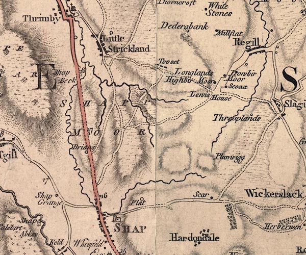
-- Brinns Farm -- "Brians" |
|
|
|
-- Castlehowe Scar -- "Scar" |
|
|
|
-- Dedra Banks -- "Dederabank" |
|
|
|
-- Flat -- "Flat" |
|
|
|
-- Gunnerkeld Sike |
|
|
|
-- High Buildings -- "Shap Grange" |
|
|
|
-- High Murber -- "Highbir Moor" |
|
|
|
-- Lewis House -- "Lewis House" |
|
|
|
-- Little Strickland -- "Little Strickland" |
|
|
|
-- Longlands -- "Longlands" |
|
|
|
-- Low Murber -- "Lowbir Moor" |
|
|
|
-- milestone, Shap Rural -- "17" |
|
|
|
-- milestone, Shap -- "16" |
|
|
|
-- milestone, Thrimby -- "18" |
|
|
|
-- New Mill Flatt -- "Millflat" |
|
|
|
-- Old Mill Flatt Farm -- "Millflat" |
|
|
|
-- Ploveriggs -- "Plumrigg" |
|
|
|
-- Shap to Bampton |
|
|
|
-- Shap to Penrith |
|
|
|
-- Scoax -- "Scoax" |
|
|
|
-- Shap Beck |
|
|
|
-- Shap Commoon -- "SHAPP MOOR" |
|
|
|
-- Shap -- "SHAP" |
|
|
|
-- Shapbeck -- "Shap Beck" |
|
|
|
-- Sleagill -- "Regill" |
|
|
|
-- St Michael's Church |
|
|
|
-- Threaplands -- "Threaplands" |
|
|
|
-- Towcett -- "Tooset" |
|
|
civil parishes The area roughly includes parts of parishes:- Thrimby Littel Strickland Newby Sleagill Shap Shap Rural Crosby Ravensworth |
||
|
|
||
|
|
Lakes Guides menu. | |