 Jefferys 1770 NY50NE

|

|
|
|
gazetteer links places may or may not be labelled on the map |
||

|
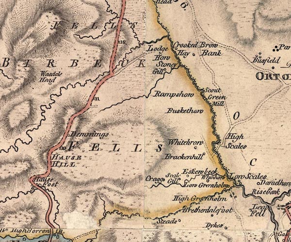
-- Birkbeck Fells Common -- "BIRBECK FELLS" |
|
|
|
-- Blea Beck |
|
|
|
-- Brackenhill -- "Brackenhill" |
|
|
|
-- Bretherdale Beck |
|
|
|
-- Bretherdale Foot -- "Bretherdalefoot" |
|
|
|
-- Buskethowe -- "Buskethaw" |
|
|
|
-- Demmings -- "Demmings" |
|
|
|
-- Eskew Beck Farm -- "Eskewbeck" |
|
|
|
-- Eskew Beck House -- "Eskewbeck" |
|
|
|
-- Eskew Beck |
|
|
|
-- Hause Hill -- "HAUSE HILL" |
|
|
|
-- Hay Banks -- "Hay Bank" |
|
|
|
-- High Crag -- "Cragg" |
|
|
|
-- High Greenholme -- "High Greenholm" |
|
|
|
-- High Scales -- "High Scales" |
|
|
|
-- High Whinhowe -- "Whinhow" |
|
|
|
-- Low Crag -- "Cragg" |
|
|
|
-- Low Greenholme -- "Low Greenholm" |
|
|
|
-- Low Scales -- "Low Scales" |
|
|
|
-- Low Whinhowe Farm -- "Whinhow" |
|
|
|
-- milestone, Orton S -- "11" |
|
|
|
-- milestone, Orton S -- "10" |
|
|
|
-- milestone, Shap Rural -- "12" |
|
|
|
-- Scout Green Mill (?) -- "Scout Green Mill" |
|
|
|
-- Rampshowe -- "Rampshow" |
|
|
|
-- Kendal to Shap |
|
|
|
-- Shap to Orton -- "F. S to O 6." |
|
|
|
-- Salterwath -- "Crooked Brow" |
|
|
|
-- Scalegill -- "Scale Gill" |
|
|
|
-- Shap Fells -- "BIRBECK FELLS" -- "SHAPP
FELLS" |
|
|
|
-- Shap Wells Hotel -- "Lodge How" |
|
|
|
-- Stonygill Beck |
|
|
|
-- Stonygill -- "Stoney Gill" |
|
|
|
-- Wasdale Beck |
|
|
|
-- Wasdale Head -- "Wasdale Head" |
|
|
|
-- Wasdale Old Bridge |
|
|
|
-- Whitebrow -- "Whitehrow" |
|
|
civil parishes The area roughly includes parts of parishes:- Shap Rural Orton S Fawcett Forest Crosby Ravensworth Tebay |
||
|
|
||
|
|
Lakes Guides menu. | |