 Jefferys 1770 NY41SW

|

|
|
|
gazetteer links places may or may not be labelled on the map |
||

|
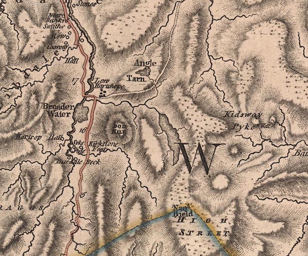
-- Angle Tarn -- "Angle Tarn" |
|
|
|
-- Brothers Water -- "Broader Water" |
|
|
|
-- Caiston Beck |
|
|
|
-- Calfgate Gill |
|
|
|
-- Caudale Bridge |
|
|
|
-- Caudale Moor |
|
|
|
-- Caudalebeck Farm -- "Burdale Beck" |
|
|
|
-- Causeway House -- "Casway" |
|
|
|
-- Cow Bridge |
|
|
|
-- Deepdale Beck |
|
|
|
-- Deepdale Bridge |
|
|
|
-- Deepdale Hall -- "Hall" |
|
|
|
-- Dovedale Beck |
|
|
|
-- Gray Crag |
|
|
|
-- Hartsop Dodd -- "DOD HILL" |
|
|
|
-- Hartsop Hall (?) -- "Hartsop Hall" |
|
|
|
-- Hartsop -- "Low Hartshope" |
|
|
|
-- Hayeswater Gill |
|
|
|
-- Hayeswater |
|
|
|
-- High Street -- "HIGH STREET" |
|
|
|
-- Horseman Bridge |
|
|
|
-- Kidsty Pike -- "Kidsway Pyke" |
|
|
|
-- Kirkstone Beck |
|
|
|
-- Kirkstonefoot -- "Kirkstone Foot" |
|
|
|
-- Nan Bield Pass -- "Nan Bield" |
|
|
|
-- Pasture Beck |
|
|
|
-- Kirkstone to Patterdale |
|
|
|
-- Row -- "Row" |
|
|
|
-- Smithy -- "Smithy" |
|
|
|
-- Sykeside -- "Syke Side" |
|
|
civil parishes The area roughly includes parts of parishes:- Patterdale Martindale Bampton Shap Kentmere |
||
|
|
||
|
|
Lakes Guides menu. | |