 Jefferys 1770 NY41NW

|

|
|
|
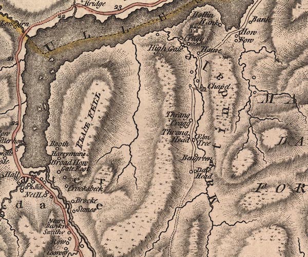
gazetteer links places may or may not be labelled on the map |
||

|
-- Bannerdale Beck |
|
|
|
-- Beda Fell |
|
|
|
-- Booth -- "Booth" |
|
|
|
-- Boredale Beck |
|
|
|
-- Broad How -- "Broad How" |
|
|
|
-- Brocke -- "Brocke" |
|
|
|
-- Cragg -- "Cragg" |
|
|
|
-- Crookbeck Farm -- "Crooksbeck" |
|
|
|
-- Dale Head -- "Dale Head" |
|
|
|
-- Elm Tree -- "Elm Tree" |
|
|
|
-- Fusedale Beck |
|
|
|
-- Gate Foot -- "Gate Foot" |
|
|
|
-- Goldrill Beck |
|
|
|
-- Hallin Fell -- "Hollin Fell" |
|
|
|
-- Harryman's -- "Harrymans" |
|
|
|
-- Hause Farm -- "Hause" |
|
|
|
-- High Ben Green -- "Be[n]green" |
|
|
|
-- Highgate -- "High Gate" |
|
|
|
-- Howegrain Beck |
|
|
|
-- Howtown -- "How Fow" |
|
|
|
-- Low Ben Green -- "Be[n]green" |
|
|
|
-- Martindale -- "Martindale" |
|
|
|
-- Noran Bank Farm -- "Near Bank" |
|
|
|
-- Patterdale -- "Patterdale" |
|
|
|
-- Place Fell -- "PLACE FELL" |
|
|
|
-- Rampsgill Beck |
|
|
|
-- Kirkstone to Patterdale |
|
|
|
-- St Martin's Church -- "Chapel" |
|
|
|
-- Stones -- "Stones" |
|
|
|
-- Thrang Head -- "Thrang Head" |
|
|
|
-- Thrangcrag -- "Thrang Crag" |
|
|
|
-- Ullswater -- "ULLESWATER" |
|
|
civil parishes The area roughly includes parts of parishes:- Matterdale Patterdale Martindale |
||
|
|
||
|
|
Lakes Guides menu. | |