 Jefferys 1770 NY40NE

|

|
|
|
gazetteer links places may or may not be labelled on the map |
||

|
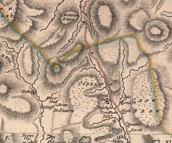
-- Branstree |
|
|
|
-- Brockstones -- "Brockstone" |
|
|
|
-- Brow Gill |
|
|
|
-- Goat Scar -- "CODKA" |
|
|
|
-- Hallow Bank -- "Brow" |
|
|
|
-- Harter Fell -- "HARTER FELL" |
|
|
|
-- Hartrigg -- "Hathrigg" |
|
|
|
-- High Swinklebank -- "High" |
|
|
|
-- Hill Cottage -- "Hill" |
|
|
|
-- Kent, River -- "Kent R." -- "Kent R." --
"KENT RIVER" |
|
|
|
-- Longsleddale -- "Long Sleddale" |
|
|
|
-- Low Sadgill -- "Sand Gills" |
|
|
|
-- Middle Swinklebank -- "Swinkle Bank" |
|
|
|
-- Overend -- "Dever End" |
|
|
|
-- Pouthowe -- "Fallday" |
|
|
|
-- Garnett Bridge to Sadgill |
|
|
|
-- Stockdale Beck |
|
|
|
-- Stockdale -- "Little London" |
|
|
|
-- Tills Hole -- "Ingshole" |
|
|
|
-- Toms Howe -- "Tomshow" |
|
|
|
-- Gatescarth to Mardale-- Gatescarth to Mardale |
|
|
|
-- Sadgill to Gatescarth |
|
|
civil parishes The area roughly includes parts of parishes:- Shap Rural Longsleddale Kentmere |
||
|
|
||
|
|
Lakes Guides menu. | |