 Jefferys 1770 NY30SW

|

|
|
|
gazetteer links places may or may not be labelled on the map |
||

|
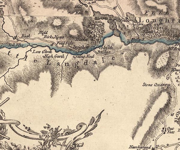
-- Bield, The -- "Bield" |
|
|
|
-- Brathay, River |
|
|
|
-- Colwith Bridge -- "Colwith Bridge" |
|
|
|
-- Elter Water -- "ELTER WATER" |
|
|
|
-- Elters -- "Elters" |
|
|
|
-- Hacket Forge -- "F[o ]" |
|
|
|
-- High Birk Howe -- "Birk Hows" |
|
|
|
-- High Hacket -- "Hacket" |
|
|
|
-- High Hall Garth -- "High Garth" |
|
|
|
-- Iving Howe -- "Ivinghow" |
|
|
|
-- Little Langdale Tarn |
|
|
|
-- Little Langdale -- "Little Langdale" |
|
|
|
-- Loughrigg Fold -- "Foulds" |
|
|
|
-- Loughrigg Tarn |
|
|
|
-- Low Birk Howe -- "Birk Hows" |
|
|
|
-- Low Hacket -- "Hacket" |
|
|
|
-- Low Hall Garth -- "Low Garth" |
|
|
|
-- Skelwith Mill (?) |
|
|
|
-- Langdale Valleys road |
|
|
|
-- Skelwith Bridge to Ravenglass -- "From White
Haven" |
|
|
|
-- Skelwith Bridge bridge -- "Skellet B." |
|
|
|
-- Skelwith Bridge -- "Skellet B." |
|
|
|
-- Stang End -- "Stang End" |
|
|
|
-- Tarn Foot -- "Tarn Foot" |
|
|
|
-- Wilson Place -- "Field Side" |
|
|
civil parishes The area roughly includes parts of parishes:- Lakes Coniston Skelwith Hawkshead |
||
|
|
||
|
|
Lakes Guides menu. | |