 Jefferys 1770 NY20NE

|

|
|
|
gazetteer links places may or may not be labelled on the map |
||

|
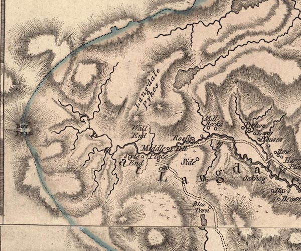
-- Blea Tarn |
|
|
|
-- Bleatarn House -- "Blea Tarn" |
|
|
|
-- Bow Fell -- "BOW FELL" |
|
|
|
-- Crinkle Crags |
|
|
|
-- Great Langdale -- "Great Langdale" |
|
|
|
-- Langdale Pikes -- "Langdale Pykes" |
|
|
|
-- Mickleden Beck |
|
|
|
-- Middle Fell Farm -- "Middle Place" |
|
|
|
-- Millbeck -- "Mill Becks" |
|
|
|
-- Pike of Blisco |
|
|
|
-- Pye Howe -- "Pyehow" |
|
|
|
-- Langdale Valleys road |
|
|
|
-- Rossett Gill |
|
|
|
-- Rossett -- "Rossi[t] Fell" |
|
|
|
-- Side House -- "Side" |
|
|
|
-- Stake Gill |
|
|
|
-- Stickle Gill |
|
|
|
-- Stickle Tarn |
|
|
|
-- Stool End -- "Style End" |
|
|
|
-- Wall End -- "Wall End" |
|
|
civil parishes The area roughly includes parts of parishes:- Borrowdale Lakes |
||
|
|
||
|
|
Lakes Guides menu. | |