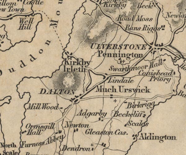
 Ford 1839 map SD27


|

|
|
|
gazetteer links places may or may not be labelled on the map |
||

|
-- Aldingham -- "Aldingham" |
|
|
|
-- Baycliff -- "Beckcliff" |
|
|
|
-- Birkrigg -- "Birkrigg" |
|
|
|
-- Dalton-in-Furness -- "DALTON" |
|
|
|
-- Duddon Estuary -- "Duddon Mouth" |
|
|
|
-- Furness Abbey -- "Furness Abbey" |
|
|
|
-- Gleaston Castle -- "Gleaston Cas." |
|
|
|
-- Great Urswick -- "Much Urswick" |
|
|
|
-- Kirkby Ireleth -- "Kirkby Ireleth" |
|
|
|
-- Lindal in Furness -- "Lindale" |
|
|
|
-- Millwood -- "Mill Wood" |
|
|
|
-- Newton -- "Newton" |
|
|
|
-- Pennington -- "Pennington" |
|
|
|
-- Rathmoss -- "Road Moss" |
|
|
|
-- Newby Bridge to Ulverston |
|
|
|
-- Scales -- "Scales" |
|
|
|
-- Stainton with Adgarley -- "Adgarby" |
|
|
|
-- Ulverston -- "ULVERSTONE" |
|
|
civil parishes The area roughly includes parts of parishes:- Dalton Town with Newton Aldingham Ulverston Osmotherley Egton with Newland Pennington Lindal and Marton Mansriggs Urswick Kirkby Ireleth Askam and Ireleth Barrow-in-Furness |
||
|
|
||
|
|
Lakes Guides menu. | |