 Ford 1839 map NY76


|

|
|
|
gazetteer links places may or may not be labelled on the map |
||

|
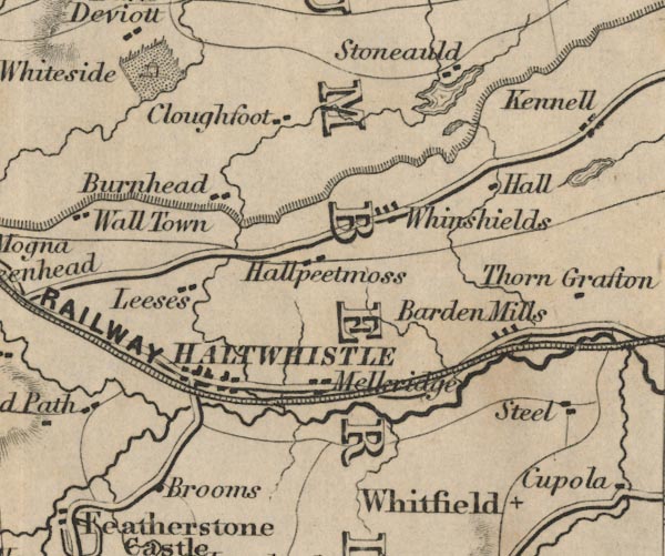
-- Bardon Mill -- "Barden Mills" |
|
|
|
-- Broomhouse -- "Brooms" |
|
|
|
-- Broomlee Lough |
|
|
|
-- Burnhead -- "Burnhead" |
|
|
|
-- Cleughfoot -- "Cloughfoot" |
|
|
|
-- Greenlee Lough |
|
|
|
-- Hadrian's Wall |
|
|
|
-- Hallpeat Moss -- "Hallpeetmoss" |
|
|
|
-- Haltwhistle -- "HALTWHISTLE" |
|
|
|
-- Lees Hall -- "Leeses" |
|
|
|
-- Melkridge -- "Melkridge" |
|
|
|
-- Newcastle and Carlisle Railway-- Newcastle and Carlisle
Railway-- Newcastle and Carlisle Railway-- Newcastle and Carlisle
Railway-- Newcastle and Carlisle Railway -- "NEWCASTLE AND
CARLISLE RAILWAY" |
|
|
|
-- Haltwhistle to Brampton |
|
|
|
-- West Stonefolds -- "Stoneauld" |
|
|
|
-- Whiteside -- "Whiteside" |
|
|
|
-- Winshields -- "Whinshields" |
|
|
counties The area includes parts of counties:- Northumberland |
||
|
|
||
|
|
Lakes Guides menu. | |