 Ford 1839 map NY31


|

|
|
|
gazetteer links places may or may not be labelled on the map |
||

|
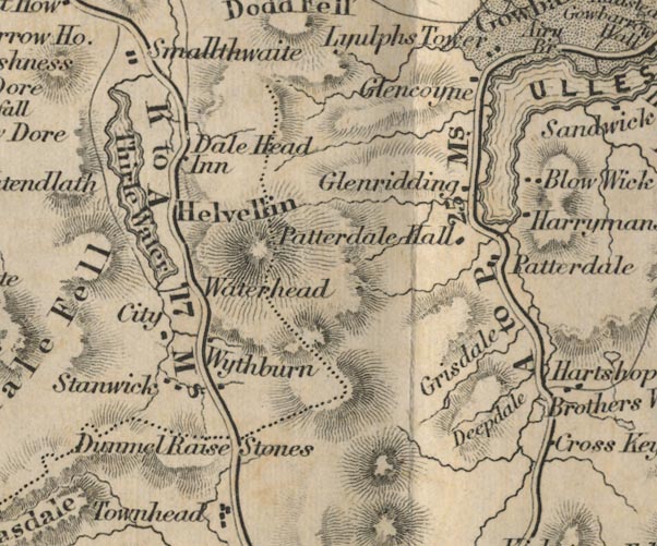
-- Blowick -- "Blow Wick" |
|
|
|
-- Brothers Water -- "Brothers Water" |
|
|
|
-- City -- "City" |
|
|
|
-- Deepdale -- "Deepdale" |
|
|
|
-- Dunmail Raise Stones -- "Dunmail Raise Stones" |
|
|
|
-- Glencoyne -- "Glencoyne" |
|
|
|
-- Glenridding -- "Glenridding" |
|
|
|
-- Grisedale Tarn |
|
|
|
-- Grisedale -- "Grisdale" |
|
|
|
-- Harryman's -- "Harrymans" |
|
|
|
-- Helvellyn -- "Helvellin" |
|
|
|
-- King's Head -- "Dale Head Inn" |
|
|
|
-- Patterdale Hall -- "Patterdale Hall" |
|
|
|
-- Patterdale -- "Patterdale" |
|
|
|
-- Ambleside to Keswick -- "K to A 17 Ms." |
|
|
|
-- Kirkstone to Patterdale -- "A to P 25 Ms." |
|
|
|
-- Patterdale to Penrith |
|
|
|
-- Stenock -- "Stanwick" |
|
|
|
-- Thirlmere -- "Thirle Water" |
|
|
|
-- Ullswater -- "ULLES WATER"-- Ullswater-- Ullswater
-- "ULLES WATER"-- Ullswater -- "ULLES
WATER" |
|
|
|
-- Wythburn -- "Wythburn" -- "Waterhead" |
|
|
civil parishes The area roughly includes parts of parishes:- Lakes Matterdale Martindale St John's Castlerigg and Wythburn Patterdale |
||
|
|
||
|
|
Lakes Guides menu. | |