 British Rainfall 1874, map

|

|
|
|

|
introduction | ||
|
|
previous | ||
|
British Rainfall 1874, map
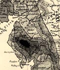
Rainfall, Mapped by Isohyets Frontispiece to British Rainfall, 1874. An example of a countrywide rainfall map using isohyets.
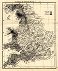 Rainfall map, Rainfall of October 6th 1874, England and Wales, by G J Symons and Stanford's Geographical Establishment, published by Edward Stanford and Co, 6 Charing Cross, and Simpkin, Marshall and Co, Stationers' Hall Court, London, 1875.
 |
|||
|
|
next | ||
|
|
|||
Lakes Guides menu.