 Old Cumbria Gazetteer
 |
 |
|
| included in:- |
 Knoll, Ambleside Knoll, Ambleside |
|
| sundial, Knoll | ||
| site name:- | Knoll, The | |
| Street:- | Rydal Road | |
| locality:- | Ambleside | |
| civil parish:- | Lakes (formerly Westmorland) | |
| county:- | Cumbria | |
| locality type:- | sundial | |
| coordinates:- | NY37320479 (about) | |
| 1Km square:- | NY3704 | |
| 10Km square:- | NY30 | |
|
|
||
| evidence:- | old map:- OS County Series (Wmd 26 6) |
|
| source data:- | Maps, County Series maps of Great Britain, scales 6 and 25
inches to 1 mile, published by the Ordnance Survey, Southampton,
Hampshire, from about 1863 to 1948. "Sundial" |
|
|
|
||
| evidence:- | old photograph:- Bell 1880s-1940s |
|
| source data:- | Photograph, b/w, sundial, The Knoll, Ambleside, Westmorland, by Herbert Bell, Ambleside,
Westmorland, 1890s?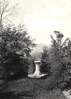 click to enlarge click to enlargeHB0341.jpg stamped at reverse:- "HERBERT BELL / Photographer / AMBLESIDE" item:- Armitt Library : ALPS705 Image © see bottom of page |
|
|
|
||
Lakes Guides menu.