 Old Cumbria Gazetteer
 |
 |
|
| roman road 7d, Cumbria | ||
| locality:- | Low Borrow Bridge | |
| civil parish:- | Tebay (formerly Westmorland) | |
| county:- | Cumbria | |
| locality:- | Brougham | |
| civil parish:- | Brougham (formerly Westmorland) | |
| county:- | Cumbria | |
| locality type:- | roman road | |
| locality type:- | road | |
| 10Km square:- | NY60 | |
| 10Km square:- | NY50 | |
| 10Km square:- | NY51 | |
| 10Km square:- | NY52 | |
| references:- | Margary, Ivan D: 1973 (3rd edn): Roman Roads in Britain: Baker, John (London):: ISBN
0 212 97001 1; describes the route in moderate detail |
|
|
|
||
| evidence:- | old map:- Stukeley 1723 |
|
| source data:- | Road map, uncoloured engraving, the Antonine Itineraries through
Britain, scale about 55 miles to 1 inch, plotted by William
Stukeley, 1723, published London, 1724.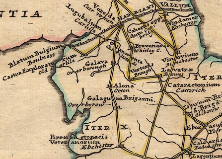 click to enlarge click to enlargeStu1Cm.jpg "ITER X." item:- Hampshire Museums : FA2001.171 Image © see bottom of page |
|
|
|
||
| :- |
References cited by Margary |
|
| Ross, P:: Bradford Ant[ ]: vol.7: p.1 Ross, P:: CWAAS: new series vol.20: p.1 |
||
|
|
||
| mapping:- | In Westmorland and Cumberland, approximately:- | |
| to link:- |  roman fort, Low Borrow Bridge (passing by the east gate) roman fort, Low Borrow Bridge (passing by the east gate) |
|
| place:- | NY61350286 (?) | |
| place:- | NY61070520 (?) / Birk Beck / Tebay / Cumbria | |
| place:- | NY60330757 | |
| place:- | NY60200912 | |
| place:- | NY59951008 / Crosby Ravensworth Fell / Crosby Ravensworth / Cumbria | |
| place:- | NY60421186 / Wicker Street / Crosby Ravensworth Fell / Crosby Ravensworth / Cumbria | |
| place:- | NY60891353 / Ewe Close / Crosby Ravensworth / Cumbria | |
| place:- | NY61011428 (?) | |
| place:- | NY60891569 / Wickerslack / Crosby Ravensworth / Cumbria | |
| place:- | NY60871660 / ford / Low Wood Beck | |
| place:- | NY60491758 / Reagill / Crosby Ravensworth / Cumbria | |
| place:- | NY59611918 / Sleagill / Sleagill / Cumbria | |
| place identity:- | Street, Great Strickland |
|
| place:- | NY57162449 (?) / Gilshaughlin House / Cliburn / Cumbria | |
| place identity:- | Moor Lane, Brougham |
|
| to link:- | roman fort, Brougham (passes by east gate) |
|
|
|
||
Lakes Guides menu.