 Old Cumbria Gazetteer
 |
 |
|
| Scar Top Fall, North Yorkshire | ||
| Scar Top Falls | ||
| county:- | North Yorkshire | |
| locality type:- | waterfall | |
| coordinates:- | SD74467952 | |
| coordinates:- | SD74397959 | |
| 1Km square:- | SD7479 | |
| 10Km square:- | SD77 | |
|
|
||
| evidence:- | descriptive text:- Balderston c1890 placename:- Scar Top Fall |
|
| source data:- | Book, Ingleton, Bygone and Present, by Robert R and Margaret
Balderston, published by Simpkin, Marshall and Co, London, and
by Edmndson and Co, 24 High Street, Skipton, Yorkshire, about
1890. goto source goto sourcepage 76:- "..." "Scar Top Fall." "Close to Homeshaw Cave is a small stream which is usually nearly dry, but precipitates itself over a limestone rock in one leap of twenty-six feet, with another of four and a half just beyond. In wet weather this fall is remarkably fine, and the point selected by the stream for its passage over the scar is exceedingly peculiar, for no one would suspect that such a fine fall would be found in such a situation, if unacquainted with the natural configuration of the place." |
|
|
|
||
| evidence:- | old map:- Balderston c1890 map placename:- Scartopfall |
|
| source data:- | Map, the hills in the Ingleton area, probably by Robert R
Balderston, engraved by Goodall and Suddick, Leeds, West
Yorkshire, about 1890.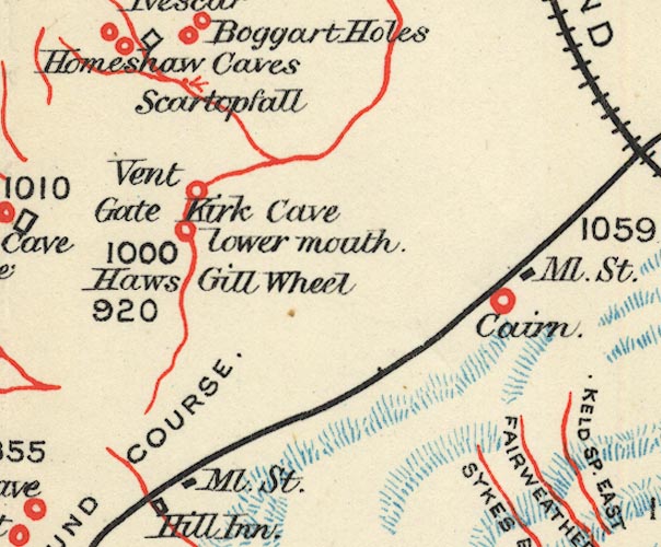 BS1SD77P.jpg "Scartopfall" item:- private collection : 27.1 Image © see bottom of page |
|
|
|
||
Lakes Guides menu.