 Old Cumbria Gazetteer
 |
 |
|
| Mitchelland, Crook | ||
| Mitchelland | ||
| locality:- | Crook | |
| civil parish:- | Crook (formerly Westmorland) | |
| county:- | Cumbria | |
| locality type:- | buildings | |
| coordinates:- | SD43369505 | |
| 1Km square:- | SD4395 | |
| 10Km square:- | SD49 | |
|
|
||
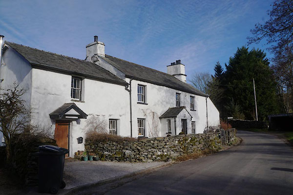 CCH45.jpg (taken 4.2.2015) |
||
|
|
||
| evidence:- | old map:- OS County Series (Wmd 33 13) placename:- Mitchelland |
|
| source data:- | Maps, County Series maps of Great Britain, scales 6 and 25
inches to 1 mile, published by the Ordnance Survey, Southampton,
Hampshire, from about 1863 to 1948. |
|
|
|
||
| evidence:- | hearth tax returns:- Hearth Tax 1675 placename:- Mitchell land |
|
| source data:- | Records, hearth tax survey returns, Westmorland, 1674/75. "Mitchell land" in "Undermillbeck" |
|
|
|
||
| evidence:- | database:- Listed Buildings 2010 placename:- Michelland House item:- spice cupboard |
|
| source data:- | courtesy of English Heritage "MICHELLAND HOUSE AND ATTACHED OUTBUILDINGS / / / CROOK / SOUTH LAKELAND / CUMBRIA / II / 76392 / SD4336495057" |
|
|
|
||
| evidence:- | database:- Listed Buildings 2010 |
|
| source data:- | courtesy of English Heritage "BARN TO NORTH EAST OF MICHELLAND HOUSE / / / CROOK / SOUTH LAKELAND / CUMBRIA / II / 76393 / SD4337895083" |
|
|
|
||
 Lakes Guides menu.