 Old Cumbria Gazetteer
 |
 |
|
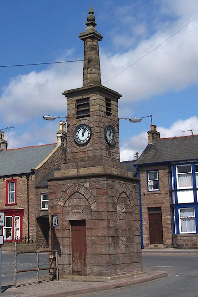
| clock tower, Brough | ||
| Street:- | New Road | |
| locality:- | Brough | |
| civil parish:- | Brough (formerly Westmorland) | |
| county:- | Cumbria | |
| locality type:- | clock tower | |
| locality type:- | market cross (site) | |
| locality type:- | cross (site) | |
| coordinates:- | NY79501460 | |
| 1Km square:- | NY7914 | |
| 10Km square:- | NY71 | |
|
|
||
 BLX18.jpg (taken 21.4.2006) |
||
|
|
||
| evidence:- | old map:- OS County Series (Wmd 16 15) |
|
| source data:- | Maps, County Series maps of Great Britain, scales 6 and 25
inches to 1 mile, published by the Ordnance Survey, Southampton,
Hampshire, from about 1863 to 1948. "Cross" |
|
|
|
||
| evidence:- | database:- Listed Buildings 2010 |
|
| source data:- | courtesy of English Heritage "CLOCK TOWER ON TRAFFIC ISLAND AT JUNCTION WITH MARKET STREET / / NEW ROAD / BROUGH / EDEN / CUMBRIA / II / 73309 / NY7950314608" |
|
| source data:- | courtesy of English Heritage "Clock Tower, erected to commemorate coronation of King George V in 1911. Coursed sandstone blocks, square in plan. 2 stages. Blind pointed arches on each side of lower stage and clock, with louvred opening above, on each side of 2nd stage. Topped by tapering column with impost block supporting pointed finial." |
|
|
|
||
| hearsay:- |
The tower is dated 1911. Pevsner spotted that the column on top is earlier, and it
does appear in older pictures as part of a taller pillar, with an added street lamp. |
|
|
|
||
 Lakes Guides menu.