 Old Cumbria Gazetteer
 |
 |
|
| Bleaberry Fell, St John's Castlerigg etc | ||
| Bleaberry Fell | ||
| locality:- | Castlerigg Fell | |
| civil parish:- | St John's Castlerigg and Wythburn (formerly Cumberland) | |
| civil parish:- | Borrowdale (formerly Cumberland) | |
| county:- | Cumbria | |
| locality type:- | hill | |
| locality type:- | fell | |
| coordinates:- | NY28561957 | |
| 1Km square:- | NY2819 | |
| 10Km square:- | NY21 | |
| altitude:- | 1936 feet | |
| altitude:- | 590m | |
|
|
||
| evidence:- | old map:- OS County Series (Cmd 64 15) placename:- Bleaberry Fell |
|
| source data:- | Maps, County Series maps of Great Britain, scales 6 and 25
inches to 1 mile, published by the Ordnance Survey, Southampton,
Hampshire, from about 1863 to 1948. |
|
|
|
||
| evidence:- | mine plan:- Postlethwaite 1877 placename:- Bleaberry Fell |
|
| source data:- | Print, drawing, geological section, Section through Falcon Crag and Bleaberry Fell,
Borrowdale, Cumberland, by J C Ward, published by W H Moss and Sons, 13 Lowther Street,
Whitehaven, Cumberland, 1877 edn 1913.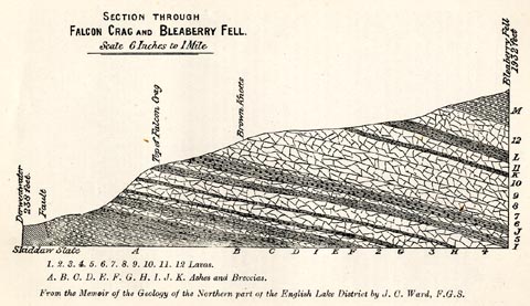 click to enlarge click to enlargePST309.jpg On p.20 of Mines and Mining in the English Lake District, by John Postlethwaite. printed, upper left "SECTION THROUGH / FALCON CRAG AND BLEABERRY FELL. / ..." printed, bottom "... / From the Memoir of the Geology of the Northern part of the English Lake District by J. C. Ward, F.G.S." item:- JandMN : 162.11 Image © see bottom of page |
|
|
|
||
| evidence:- | presumably outline view:- Martineau 1855 placename:- Bleaberry Fell |
|
| source data:- | Print, uncoloured engraving, outline view, Mountains seen on the Keswick Road approaching
Ullswater, drawn by L Aspland, engraved by W Banks, Edinburgh, published by John Garnett,
Windermere, Westmorland, and by Whittaker and Co, London, 1855.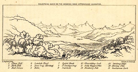 click to enlarge click to enlargePR0420.jpg Used opposite p.104 in A Complete Guide to the English Lakes, by Harriet Martineau. The view is captioned, numbers referring to mountains in the image - 1 Place Fell, 2 Birk Fell, 3 Red Screes, 4 Scandale Head, 5 Dove Crag (Hartsop), 6 Birks, 7 Rydal Head, 8 St. Sundays Crag, 9, Fairfield, 10 Glenridding Dod, 11 Dolly Waggon Pike, 12 Bleaberry Fell, 13 Striding Edge, 14 Herring Pike, 15 Gowbarrow Park. printed at top:- "MOUNTAINS SEEN ON THE KESWICK ROAD APPROACHING ULLSWATER." printed at bottom left, right:- "L Aspland Delt. / W Banks Sc Edinr. / ..." item:- Dove Cottage : 2008.107.413 Image © see bottom of page |
|
|
|
||
| evidence:- | old map:- Ford 1839 map placename:- Bleaberry Fell |
|
| source data:- | Map, uncoloured engraving, Derwent Water and Vale of Keswick,
engraved by W H Lizars, published by Charles Thurnam, Carlisle,
and by R Groombridge, 5 Paternoster Row, London, 3rd edn 1843.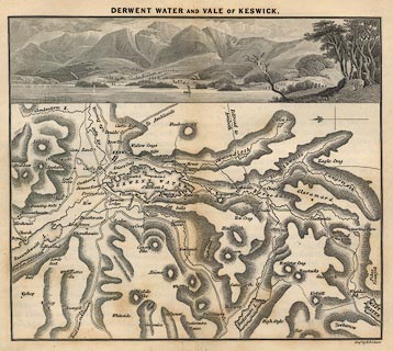 click to enlarge click to enlargeFD04.jpg Named on the map is:- "Bleaberry fell" item:- JandMN : 100.3 Image © see bottom of page |
|
|
|
||
 Lakes Guides menu.