 West 1784 map
 |
 |
|
|
Places Identified
Map, hand coloured engraving, A Map of the Lakes in Cumberland, Westmorland and Lancashire, scale about 3.5 miles to 1 inch, engraved by Paas, 53 Holborn, London, about 1784. NB: each image includes an overlap, places in the overlap are not listed. The images are roughly equivalent to ngr 10Km squares, rotated N at top, and are listed from top left to bottom right. | ||
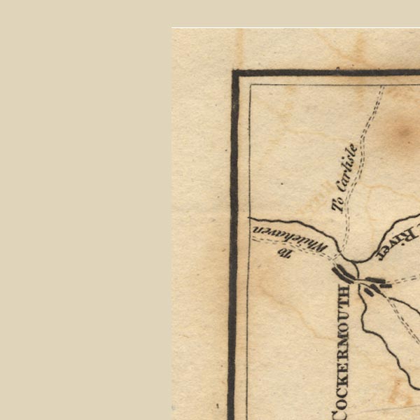 Ws02NY03.jpg
 |
Cockermouth -- building/s etc -- NY122306
| |
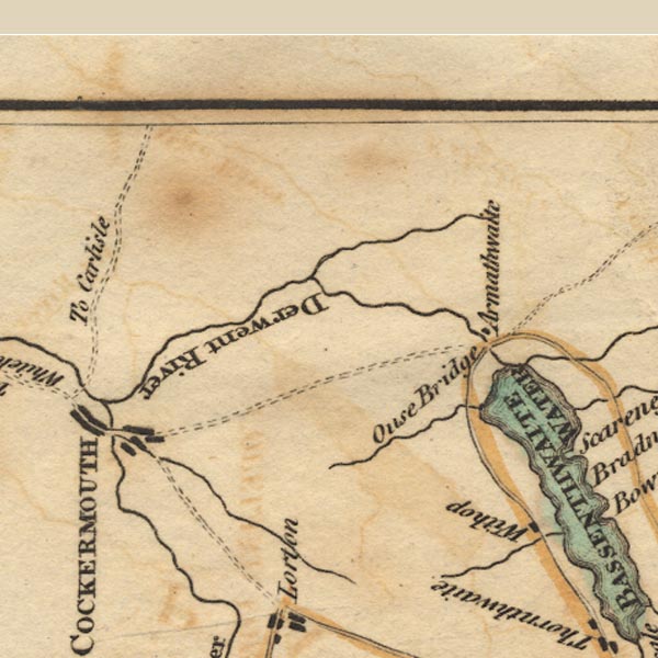 Ws02NY13.jpg
 |
Armathwaite Hall -- building/s -- hotel -- NY2032
Beck Wythop -- building/s -- NY214284 Cocker, River -- river -- NY1426 ? Derwent, River -- river etc -- NY2515 (etc) ? High Pike -- hill -- NY319349 Ouse Bridge -- bridge -- NY199321 Wythop Beck -- river -- NY1829 | |
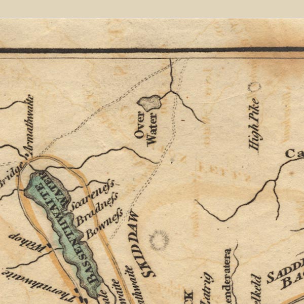 Ws02NY23.jpg
 |
Bassenthwaite Lake -- lake -- NY215298
Bowness Farm -- building/s -- NY22422905 Broadness -- building/s -- NY22252971 Dash Beck -- river -- NY2532 (etc) Ellen, River -- river etc -- NY2436 (etc) Over Water -- lake -- NY251350 Scarness -- building/s -- NY2130 | |
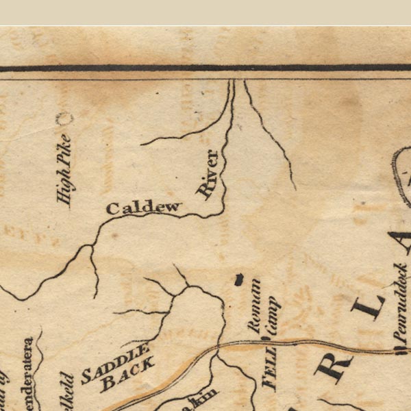 Ws02NY33.jpg
 |
Caldew, River -- river etc -- NY3851 (etc) ?
Carrock Beck -- river -- NY3435 (etc) Gillcambon Beck -- river -- NY3835 (etc) | |
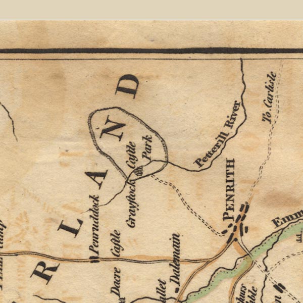 Ws02NY43.jpg
 |
Greystoke Castle -- castle -- park -- NY425309
(castle)
Penrith -- building/s etc -- NY513304 Petteril, River -- river -- NY4935 (etc etc) | |
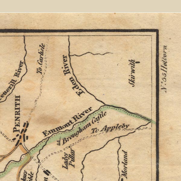 Ws02NY53.jpg
 |
Countess Pillar -- memorial -- pillar -- sundial --
NY54602895
Eamont, River -- river etc -- NY469243 (from) ? ? Eden, River -- river etc -- NY3658 (etc) Leith, River -- river -- NY5523 Lowther, River -- river etc -- NY5124 (etc) ? Skirwith -- building/s -- NY6132 | |
 Ws02NY02.jpg
 | ||
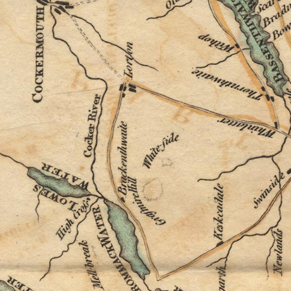 Ws02NY12.jpg
 |
Brackenthwaite -- building/s -- NY154221
Cocker, River -- river -- NY1426 ? Crummock Water -- lake -- NY158189 Grasmoor -- hill -- NY17492034 High Lorton -- building/s -- NY162257 Highcross -- building/s -- NY13662133 Keskadale Farm -- building/s -- NY21041930 Loweswater -- lake -- NY125217 ? Whiteside -- hill -- NY17042195 | |
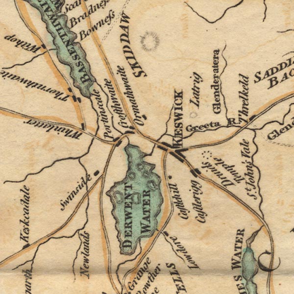 Ws02NY22.jpg
 |
Bassenthwaite Lake -- lake -- NY215298
Castle Head -- hill -- NY269227 Castlerigg -- building/s -- NY281224 Coledale Beck -- river -- NY2222 Derwent Isle -- island -- NY261224 Derwent Water -- lake etc -- NY260210 ? Glenderaterra Beck -- river -- NY2926 Great Crosthwaite -- building/s etc -- NY261242 Greta, River -- river -- NY2924 Keswick -- building/s etc -- NY266234 Latrigg -- hill -- NY279247 Lodore Hotel -- inn (hotel) -- NY264188 Lord's Island -- island -- NY265218 ? Newlands Beck -- river -- NY2319 Ormathwaite -- building/s -- NY267254 Portinscale -- building/s -- NY251235 Rampsholme Island -- island -- NY263213 St Herbert's Island -- island -- NY259212 Swinside -- locality -- NY242217 Thornthwaite -- building/s -- NY223254 ? Whinlatter -- hill -- NY19682490 | |
 Ws02NY32.jpg
 |
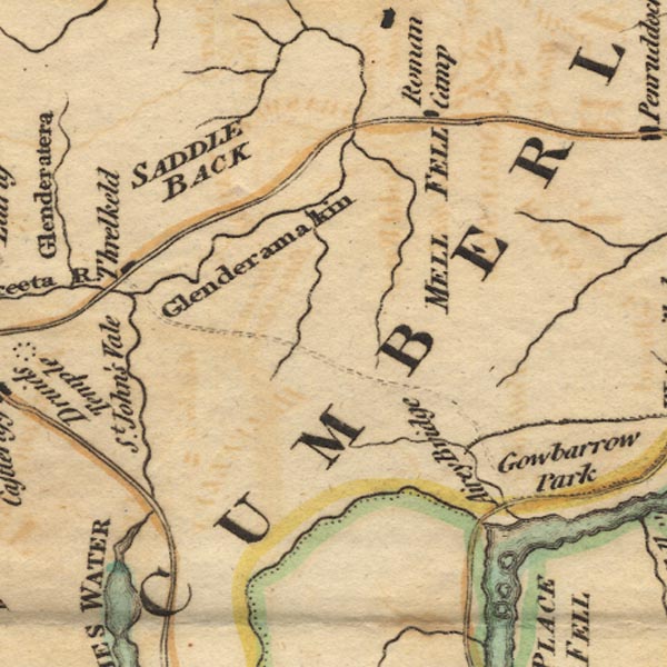
Aira Beck -- river -- NY40001974
Aira Bridge -- bridge -- NY40172003 Glencoyne Beck -- river -- NY38751881 ? Glenderamackin, River -- river -- NY3426 Gowbarrow Park -- park -- NY408212 (etc) Little Mell Fell -- hill -- NY42312402 Mosedale Beck -- river -- NY3523 roman fort, Whitbarrow -- roman fort -- roman site -- NY407282 Saddleback -- hill -- NY3127 (etc) St John's Beck -- river -- NY3123 ? Threlkeld -- building/s -- NY322254 Trout Beck -- river -- NY3826 Ullswater -- lake -- NY422202 (etc) ? | |
 Ws02NY42.jpg
 |
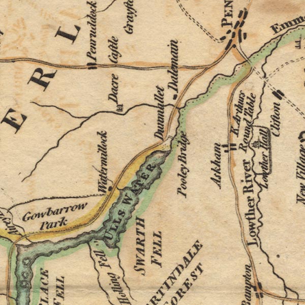
Arthur's Round Table -- henge -- NY523284
Askham -- building/s -- NY513237 Dacre Beck -- river -- NY4626 Dacre Castle -- castle -- NY46052650 Dalemain -- park -- house -- museum -- NY479269 Dunmallard Hill -- hill -- NY468246 Eamont, River -- river etc -- NY469243 (from) ? ? Fusedale Beck -- river -- NY44321989 Gowbarrow Park -- park -- NY408212 (etc) Penruddock -- building/s -- NY429276 Pooley Bridge -- bridge -- NY47002442 Rampsgill Beck -- river -- NY4315 Swarth Fell -- hill -- fell -- NY451198 Ullswater -- lake -- NY422202 (etc) ? Watermillock -- building/s -- NY445224 | |
 Ws02NY52.jpg
 |
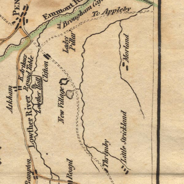
Clifton -- building/s -- NY534266
decoy pond, Lowther -- decoy pond -- pond -- NY531226 (?) Leith, River -- river -- NY5523 Lowther Castle -- castle -- NY523238 Lowther Park -- park -- NY5222 (etc) Lowther -- building/s -- NY536236 Lowther, River -- river etc -- NY5124 (etc) ? Morland -- building/s -- NY598225 | |
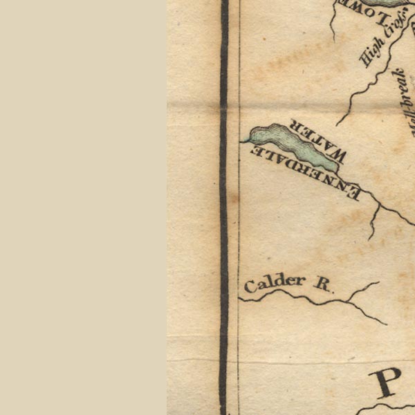 Ws02NY01.jpg
 |
Calder, River -- river etc -- NY0712 (etc) ?
Ennerdale Water -- lake -- NY106150 | |
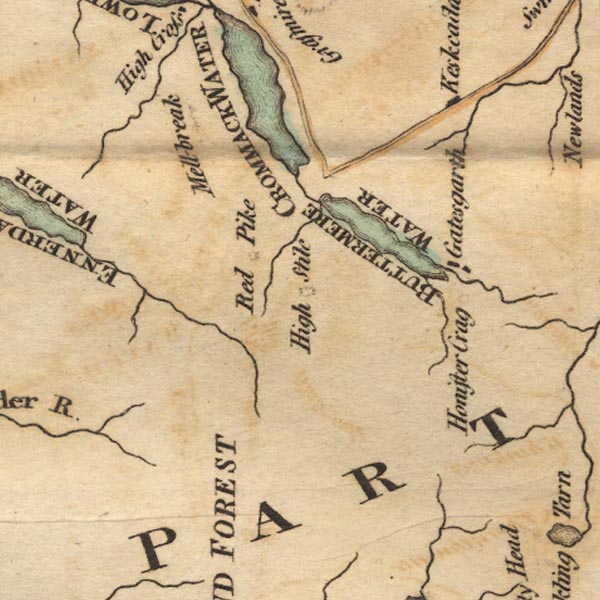 Ws02NY11.jpg
 |
Buttermere -- lake -- NY182158
Crummock Water -- lake -- NY158189 Gatesgarth -- building/s -- NY194149 Gatesgarthdale Beck -- river -- NY2014 High Stile -- hill -- NY169147 Honister Crag -- rocks -- NY211143 Keskadale Beck -- river -- NY2119 ? Liza, River -- river -- NY1613 ? Mellbreak -- hill -- NY145190 ? Red Pike -- hill -- NY16051545 Sour Milk Gill -- river -- NY1615 | |
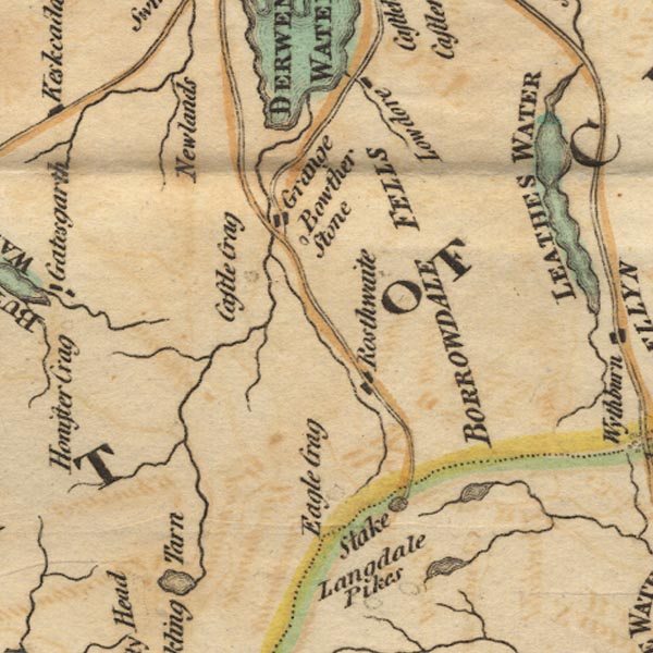 Ws02NY21.jpg
 |
Borrowdale Fells -- hill -- fell -- NY2512 (etc)
Bowder Stone -- stone -- NY25391640 Castle Crag -- rocks -- NY249159 Eagle Crag -- rocks -- NY276121 Grains Gill -- river -- NY2310 Grange -- building/s -- NY252174 Newlands -- building/s -- NY234204 (approx) ? Rosthwaite -- building/s -- NY259149 ? Stake Pass -- pass -- NY26530869 (pile of stones) Stonethwaite Beck -- river -- NY2614 | |
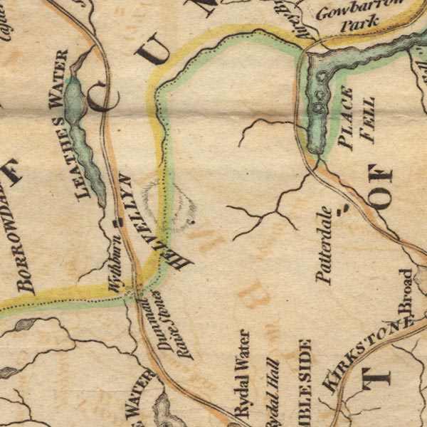 Ws02NY31.jpg
 |
Cherry Holm -- island -- trig point -- NY39221702
Glencoyne Beck -- river -- NY38751881 ? Glenridding Beck -- river -- NY35971603 ? Goldrill Beck -- river -- NY393166 Grisedale Beck -- river -- NY36451437 ? Helvellyn -- hill -- NY34261508 Norfolk Island -- island -- NY39161846 Patterdale -- building/s -- NY394160 Place Fell -- hill -- NY40561696 Thirlmere -- lake -- NY3115 (etc) ? Ullswater -- lake -- NY422202 (etc) ? Wall Holm -- island -- NY39071747 Wyth Burn -- river -- NY3112 Wythburn -- locality -- NY322130 (etc) | |
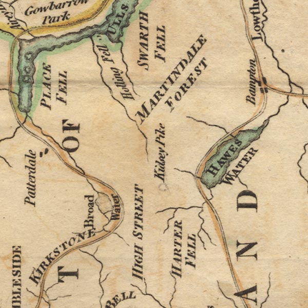 Ws02NY41.jpg
 |
Brothers Water -- lake -- NY402127 ?
Goldrill Beck -- river -- NY393166 Hallin Fell -- hill -- fell -- NY43301982 Harter Fell -- hill -- fell -- NY459093 Hawes Water -- lake -- reservoir -- NY4713 (etc) High Street -- hill etc -- NY441111 (etc) Kidsty Pike -- hill -- NY44731260 Kirkstone Pass -- pass -- NY401080 Martindale Common -- common -- NY4216 | |
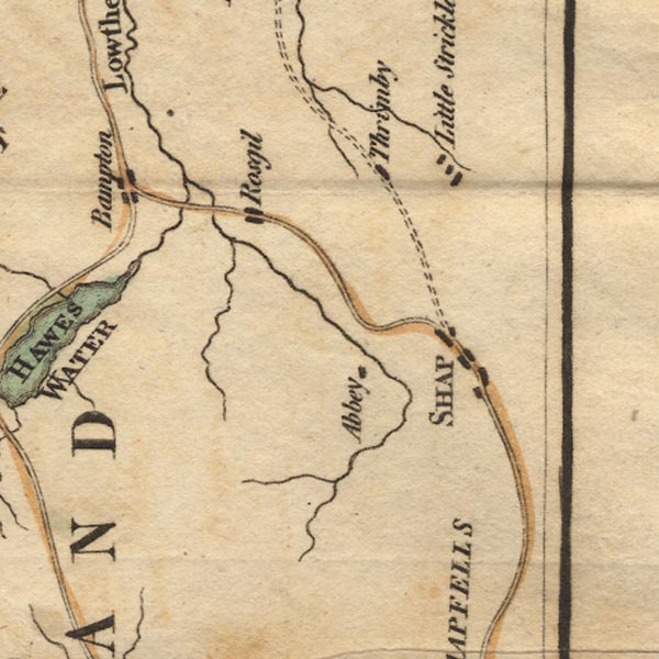 Ws02NY51.jpg
 |
Bampton -- building/s -- NY521180
Haweswater Beck -- river -- NY5116 Little Strickland -- building/s -- NY5619 ? Lowther, River -- river etc -- NY5124 (etc) ? Rosgill -- building/s -- NY537167 Shap Abbey -- abbey -- religious house -- NY548153 Shap -- building/s etc -- NY562153 Swindale Beck -- river -- NY535164 Thrimby -- building/s -- NY5520 | |
 Ws02NY00.jpg
 |
Irt, River -- river etc -- NY1002 (etc) ?
| |
 Ws02NY10.jpg
 |
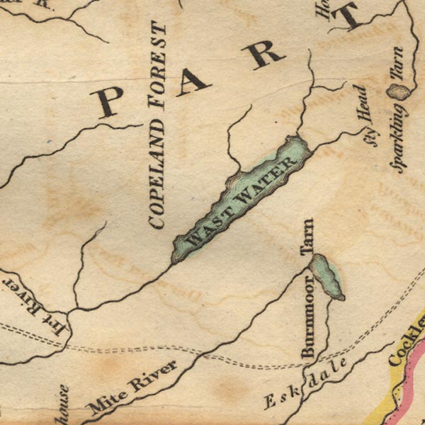
Burnmoor Tarn -- lake -- NY183043 ?
Copeland Forest -- forest -- NY10 (etc) Irt, River -- river etc -- NY1002 (etc) ? Lingmell Beck -- river -- NY1908 ? Mosedale Beck -- river -- NY1808 Nether Beck -- river -- NY1508 Wast Water -- lake -- NY161059 Whillan Beck -- river -- NY1803 | |
 Ws02NY20.jpg
 |
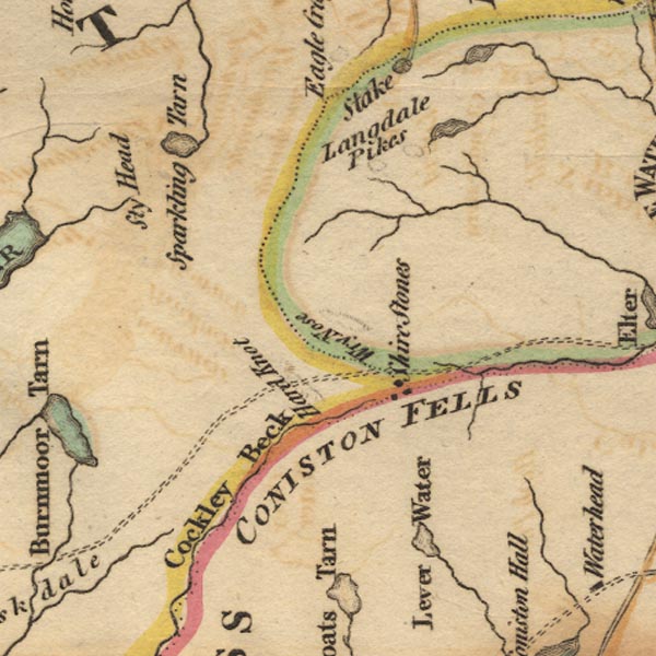
Brathay, River -- river -- NY3503
Coniston Fells -- hill -- fell -- SD2898 (etc) Duddon, River -- river etc -- NY2602 (etc) Easedale Tarn -- lake -- NY307087 (etc) Great Langdale Beck -- river -- NY3105 Hardknott Pass -- pass -- NY23150146 (etc) Langdale Pikes -- hill -- NY2707 Mite, River -- river etc -- NY1602 Sprinkling Tarn -- lake -- NY228091 Sty Head -- pass -- NY218094 Three Shire Stones -- boundary stone -- stone -- NY27720274 ? Wrynose Pass -- pass -- NY27700270 | |
 Ws02NY30.jpg
 |
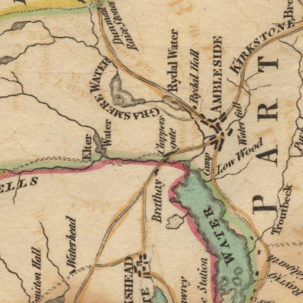
Ambleside -- building/s etc -- NY376045 ?
Blelham Tarn -- lake -- NY365004 Brathay, River -- river -- NY3503 Clappersgate -- building/s -- NY366033 Elter Water -- lake -- NY333041 Grasmere -- lake -- NY337066 Great Langdale Beck -- river -- NY3105 Kirkstone Pass -- pass -- NY401080 Low Wood -- building/s etc -- NY39400156 Old Brathay -- building/s -- NY367034 Galava -- roman fort -- roman site -- NY376033 Rothay, River -- river -- NY3308 (etct) Rydal Hall -- building/s -- NY365064 Rydal Water -- lake -- NY355061 Stock Ghyll -- river -- NY3905 Stockghyll Force -- waterfall -- NY382045 Windermere -- lake -- SD392950 ? | |
 Ws02NY40.jpg
 |
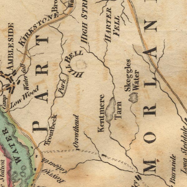
Ill Bell -- hill -- NY43650774
Kent, River -- river etc -- NY4506 (etc) Kentmere Tarn -- lake -- NY455028 (approx) Skeggles Water -- lake -- NY479034 Sprint, River -- river etc -- NY4806 (etc) Trout Beck -- river -- NY4104 (etc) ? Troutbeck Park -- park -- NY4205 | |
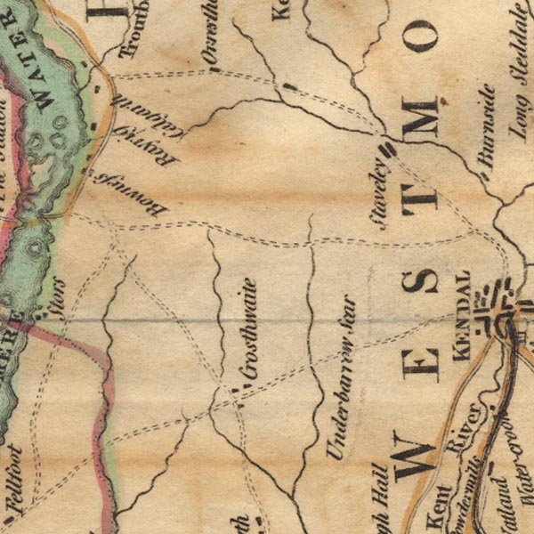
 Ws02NY50.jpg
 |
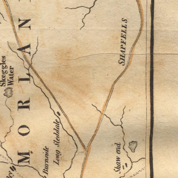
Bannisdale Beck -- river -- NY5202
Longsleddale -- valley -- NY4904 (etc) Mint, River -- river -- SD5596 Shap Fells -- hill -- fell -- NY5309 Sprint, River -- river etc -- NY4806 (etc) | |
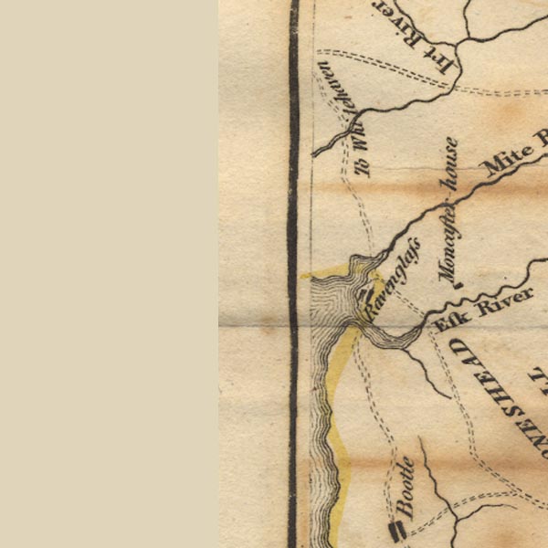 Ws02SD09.jpg
 |
Esk Estuary (?) -- estuary -- river estuary -- SD0896
Esk, River -- river etc -- NY2101 (etc) ? Irt, River -- river etc -- NY1002 (etc) ? Muncaster Castle -- castle -- museum -- SD103964 ? Ravenglass -- building/s etc -- SD085964 | |
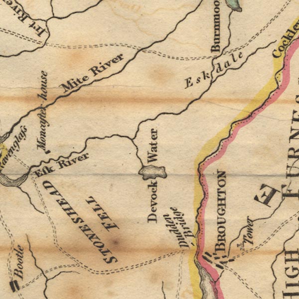 Ws02SD19.jpg
 |
Corney Fell -- hill -- fell -- SD1391
Devoke Water -- lake -- SD158969 Duddon, River -- river etc -- NY2602 (etc) Esk, River -- river etc -- NY2101 (etc) ? Eskdale -- valley -- locality -- NY1802 (etc) Linbeck Gill -- river -- SD1497 Mite, River -- river etc -- NY1602 Whillan Beck -- river -- NY1803 | |
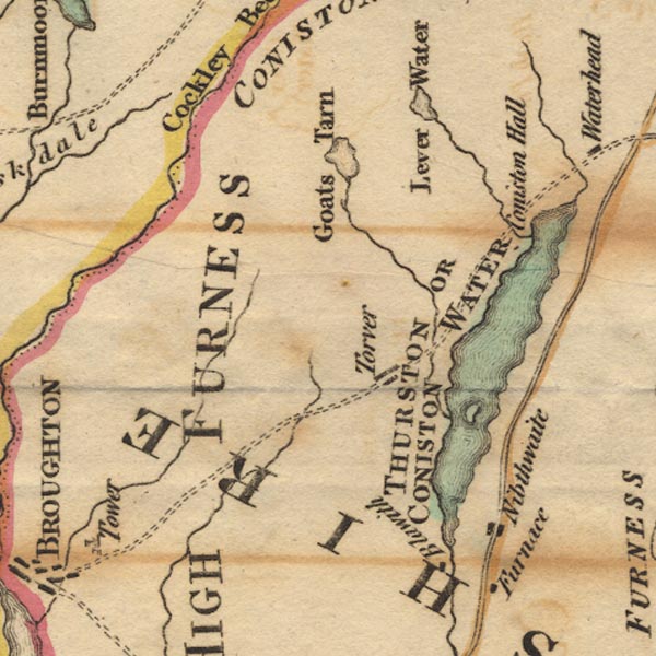 Ws02SD29.jpg
 |
Bleng, River -- river -- NY1108
Church Beck -- river -- SD30809693 Coniston Hall -- building/s -- SD30449634 Coniston Water -- lake -- SD302943 Duddon, River -- river etc -- NY2602 (etc) Goat's Water -- lake -- SD266976 High Nibthwaite -- building/s -- SD293897 Kirkby Pool -- river -- SD2386 (etc) Levers Water -- lake -- SD279992 Mite, River -- river etc -- NY1602 Peel Island -- island -- SD295918 Torver -- building/s -- SD283941 | |
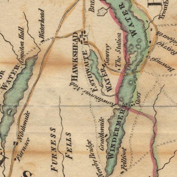 Ws02SD39.jpg
 |
Belle Isle -- island -- SD393967 ?
Cunsey Beck -- river -- SD3694 Esthwaite Water -- lake -- SD3696 (etc) Furness Fells -- hill -- fell -- SD3389 (etc) Graythwaite Hall -- building/s -- SD371913 Hawkshead -- building/s etc -- SD351980 Lady Holme -- island -- SD398974 Ling Holme -- island -- SD385936 Near Sawrey -- building/s -- SD369956 Out Dubs Tarn -- lake -- SD367948 Ramp Holme -- island -- SD393952 Rawlinson Nab -- headland -- SD385930 Rough Holme -- island -- SD39869794 Station, The -- viewpoint -- station -- house -- SD3895 Storrs -- area -- SD3994 (etc) Thompson's Holme -- island -- SD391970 Waterhead -- building/s -- SD310975 Windermere Ferry, Windermere -- ferry -- SD39109569 & SD39579581 Windermere -- lake -- SD392950 ? | |
 Ws02SD49.jpg
 |
Bowness-on-Windermere -- building/s -- NY403969 ? ?
Calgarth Hall -- building/s -- SD398996 ? Crosthwaite -- building/s -- SD437915 Gilpin, River -- river etc -- SD4490 (etc) Gowan, River -- river -- SD4598 Kent, River -- river etc -- NY4506 (etc) Orrest Head -- hill -- SD41429937 Pool, River -- river -- SD4690 (etc) Rayrigg Hall -- building/s -- SD402981 Scout Scar -- rocks -- SD4891 (etc) Staveley -- building/s etc -- SD470984 Winster, River -- river -- SD4285 (etc) | |
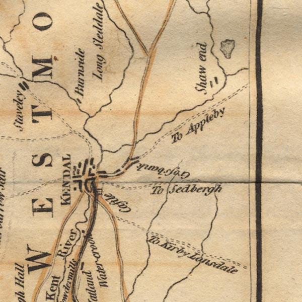 Ws02SD59.jpg
 |
Burneside -- building/s -- SD5095
Crossbank -- building/s -- SD5293 Field End -- building/s -- SD5596 Kendal Castle -- castle -- SD521924 Kendal -- building/s etc -- SD514926 Kent, River -- river etc -- NY4506 (etc) Lancaster Canal -- canal etc -- SD58 (etc) Mint, River -- river -- SD5596 Peasey Beck -- river -- SD5486 (etc) Sprint, River -- river etc -- NY4806 (etc) Stainton Beck -- river -- SD5285 (etc) Watercrook -- locality -- SD514906 (etc) | |
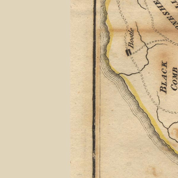 Ws02SD08.jpg
 |
Annas, River -- river -- SD0887 (etc)
Bootle -- building/s etc -- SD108883 | |
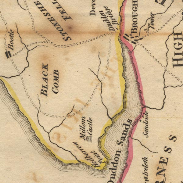 Ws02SD18.jpg
 |
Black Beck -- river -- SD1886
Black Combe -- hill -- SD135855 (summit) Broughton in Furness -- building/s etc -- SD211876 Broughton Tower -- tower -- SD213879 Duddon Bridge -- bridge -- SD19928818 Duddon Estuary -- estuary -- river estuary etc -- SD1475 (etc) Duddon Sands -- foreshore etc -- SD2081 (etc) Kirkby Pool -- river -- SD2386 (etc) Millom Castle -- castle -- SD171813 Sand Side -- building/s -- SD2282 Whicham Beck -- river -- parish boundary -- boundary -- SD1583 (etc) | |
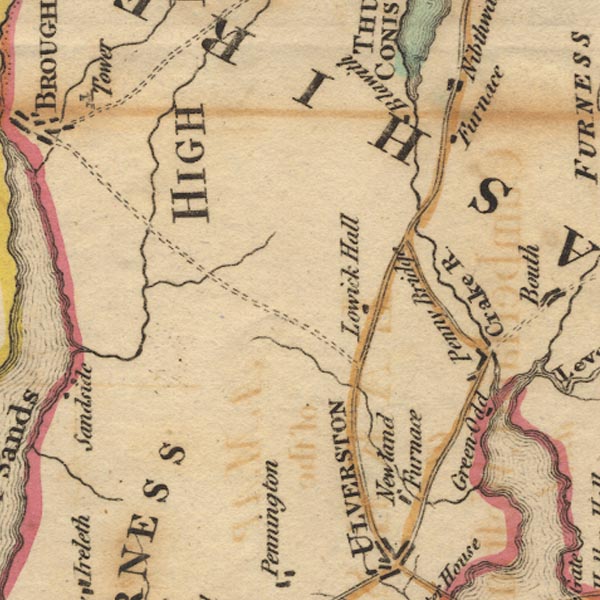 Ws02SD28.jpg
 |
Blawith -- building/s -- SD288883
Crake, River -- river etc -- SD2987 (etc) Greenodd -- building/s -- SD313825 Kirkby Pool -- river -- SD2386 (etc) Lowick Hall -- building/s -- SD28588598 Newland Beck -- river -- SD3080 (etc) Newland Ironworks (?) -- ironworks -- furnace -- SD299798 Nibthwaite Ironworks (?) -- ironworks -- furnace -- SD295883 Penny Bridge -- bridge -- SD31018329 Penny Bridge -- building/s -- SD309828 | |
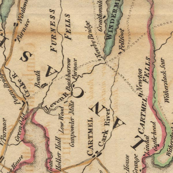 Ws02SD38.jpg
 |
Backbarrow Ironworks (?) -- ironworks -- furnace --
SD3584 (?)
Backbarrow -- building/s -- SD357847 Bouth -- building/s -- SD328856 Eea, River -- river -- SD3778 (etc) Fell Foot -- park -- SD3887 (etc) Furness Fells -- hill -- fell -- SD3389 (etc) High Newton -- building/s -- SD400828 Leven Estuary -- estuary -- river estuary -- sea area -- SD3375 (etc) Leven, River -- river etc -- SD3483 (etc) ? Low Wood -- building/s -- SD346836 Lowwood Gunpowder Mills -- gunpowder mill -- mill -- SD346836 Newby Bridge -- bridge -- SD36918636 ? Newton Fell -- hill -- fell -- SD4182 Rusland Pool -- river -- SD3487 (etc) Windermere -- lake -- SD392950 ? | |
 Ws02SD48.jpg
 |
Arndale Beck -- river -- SD4289
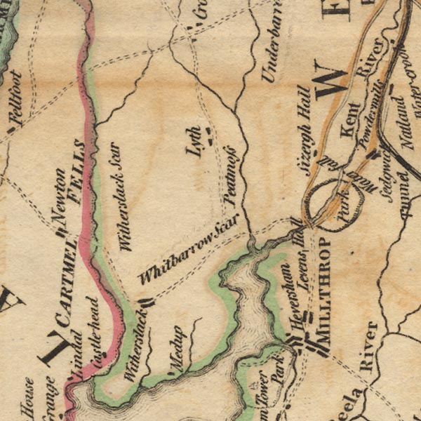
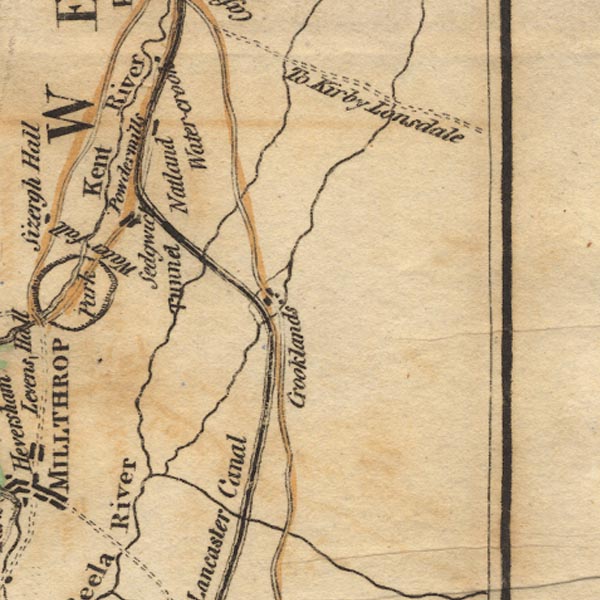
Bellart How Moss -- moss -- SD455832 (etc) Foulshaw Moss -- moss -- SD461825 (etc) Gilpin, River -- river etc -- SD4490 (etc) Heversham -- building/s -- SD497833 Kent Estuary -- estuary -- river estuary -- sea area -- SD4377 (etc) Kent, River -- river etc -- NY4506 (etc) Levens Force -- waterfall -- SD50798655 ? Levens Hall -- building/s -- house -- SD494850 Levens Park -- park -- SD5085 Lyth, Crosthwaite and Lyth -- locality -- SD48 (? area) Meathop Moss -- moss -- SD4481 Milnthorpe -- building/s -- SD496815 Pool, River -- river -- SD4690 (etc) Sizergh Castle -- building/s -- house -- park -- SD4987 Stakes Moss -- moss -- SD465846 (etc) Whitbarrow Scar -- hill -- rocks -- SD4487 (etc) White Scar -- rocks -- SD4585 Winster, River -- river -- SD4285 (etc) Witherslack -- building/s -- SD4383 | |
 Ws02SD58.jpg
 |
Crooklands -- building/s -- SD5383
Hincaster Tunnel -- canal tunnel -- tunnel -- SD51268512 (east portal) Kent, River -- river etc -- NY4506 (etc) Lancaster Canal -- canal etc -- SD58 (etc) Lupton Beck -- river -- SD5780 (etc) Natland -- building/s -- SD5289 Sedgwick Gunpowder Mills -- gunpowder mill -- mill -- SD508872 Peasey Beck -- river -- SD5486 (etc) Sedgwick -- building/s -- SD5187 Stainton Beck -- river -- SD5285 (etc) | |
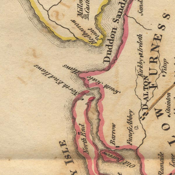 Ws02SD17.jpg
 |
Barrow-in-Furness -- building/s -- SD198689
Dalton-in-Furness -- building/s -- SD227738 Duddon Estuary -- estuary -- river estuary etc -- SD1475 (etc) Duddon Sands -- foreshore etc -- SD2081 (etc) Furness Abbey -- abbey -- religious house -- SD218717 Haverigg Pool -- river -- SD1579 (etc) Hodbarrow Point -- headland -- SD182780 Isle of Walney -- island -- SD1767 ? Kirkby -- SD2484 (area) North End Haws -- SD1773 North Scale -- building/s -- SD1870 Poaka Beck -- river -- SD2376 (etc) Sandscale Haws -- SD200756 | |
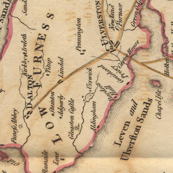 Ws02SD27.jpg
 |
Aldingham -- building/s -- SD2871
Bardsea Hall (?) -- building/s -- SD3074 (?) Carter House (?) -- building/s -- SD3177 Conishead Priory -- building/s -- religious house -- temple -- SD304757 ? Furness -- locality (ill defined) -- SD27 (etc) Gleaston Castle -- castle -- SD2671 Great Urswick -- building/s -- SD2674 Levy Beck -- river -- SD2877 Lindal in Furness -- building/s -- SD2475 Pennington -- building/s -- SD2677 Stainton with Adgarley -- building/s -- SD247724 Tytup Hall -- building/s -- SD2375 Ulverston Sands -- sands -- SD3074 (etc) Ulverston -- building/s -- SD289783 Urswick Tarn -- lake -- SD2774 | |
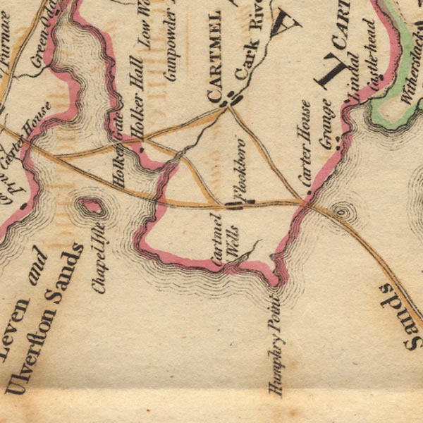 Ws02SD37.jpg
 |
Cartmel Wells (?) -- SD3673 (?)
Cartmel -- building/s -- SD382786 Chapel Island -- island -- SD311758 Eea, River -- river -- SD3778 (etc) Flookburgh -- building/s -- SD3675 Grange-over-Sands -- building/s -- SD407778 Guides Farm -- building/s -- SD401765 Holker Hall -- building/s -- house -- garden -- SD3577 Humphrey Head Point -- headland -- SD3973 Kent Estuary -- estuary -- river estuary -- sea area -- SD4377 (etc) Lancaster Sands -- sands -- foreshore -- SD47 (etc) Leven Estuary -- estuary -- river estuary -- sea area -- SD3375 (etc) Lindale -- building/s -- SD415805 Sand Gate -- building/s -- SD3575 Ulverston Sands -- sands -- SD3074 (etc) | |
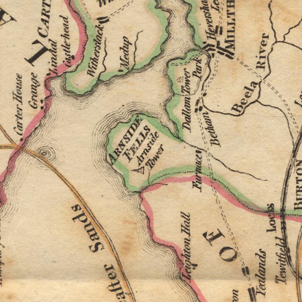 Ws02SD47.jpg
 |
Arnside Fell -- hill -- fell -- SD4577 (etc)
Arnside Tower -- tower -- SD458768 Beetham -- building/s -- SD4979 Bela, River -- river -- SD5079 (etc) Castle Head -- building/s -- field studies centre -- SD421799 Dallam Tower -- building/s -- SD490810 Kent Estuary -- estuary -- river estuary -- sea area -- SD4377 (etc) Lancaster Sands -- sands -- foreshore -- SD47 (etc) Leighton Beck -- river -- boundary -- county boundary -- SD4977 (etc) Leighton Ironworks (?) -- ironworks -- furnace -- SD47 (?) Meathop -- building/s -- SD4380 Park, The -- park -- SD4980 Skeggleswater Dike -- river -- NY4703 (etc) Winster, River -- river -- SD4285 (etc) | |
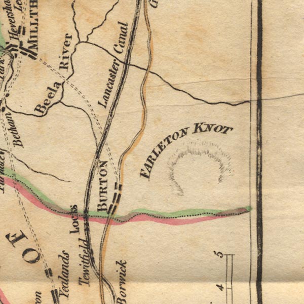 Ws02SD57.jpg
 |
Bela, River -- river -- SD5079 (etc)
Burton-in-Kendal -- building/s -- SD531765 Farleton Knott -- rocks -- SD5480 ? Lancaster Canal -- canal etc -- SD58 (etc) Lupton Beck -- river -- SD5780 (etc) Tewitfield Locks -- canal lock -- lock -- flight of locks -- SD5274 | |
 Ws02SD16.jpg
 |
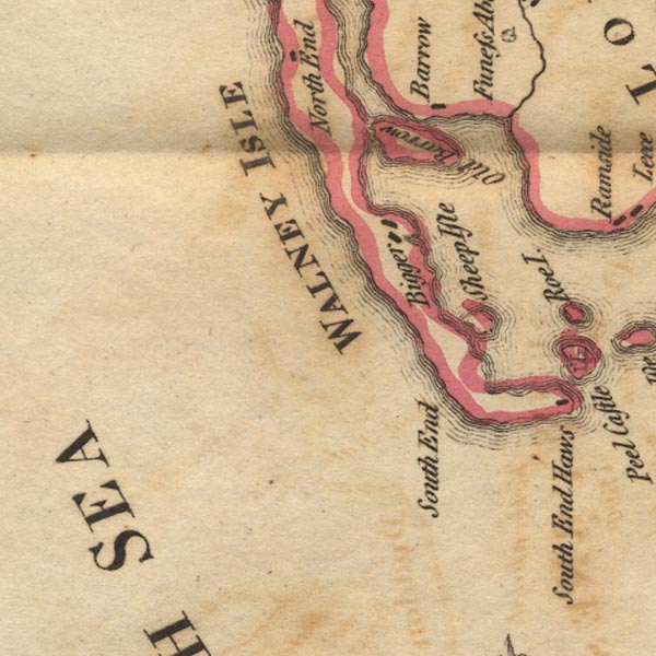
Barrow Island -- island -- SD2068
Biggar -- building/s -- SD1966 Isle of Walney -- island -- SD1767 ? Poaka Beck -- river -- SD2376 (etc) Sheep Island -- island -- SD2163 South End -- building/s -- SD2063 | |
 Ws02SD26.jpg
 |
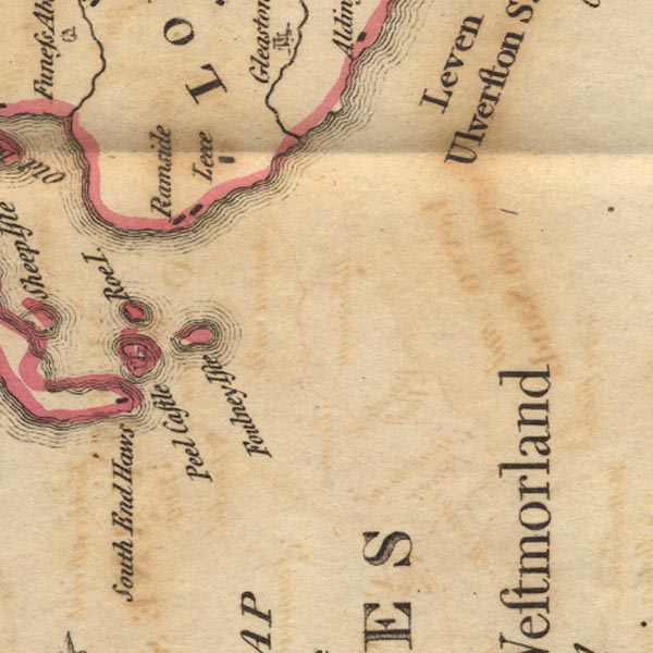
Foulney Island -- island -- SD2463
Leece -- building/s -- SD2469 Piel Castle -- castle -- SD23306357 Piel Island -- island -- SD2363 Rampside -- building/s -- SD2466 Roa Island -- island -- SD2364 South End Haws -- SD2261 | |
 Ws02SD46.jpg
 |
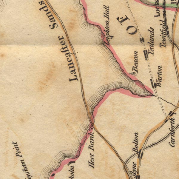
beacon, Warton -- beacon (?) -- SD4872
Hest Bank -- building/s -- SD4766 Lancaster Sands -- sands -- foreshore -- SD47 (etc) Leighton Hall -- building/s -- SD494744 | |
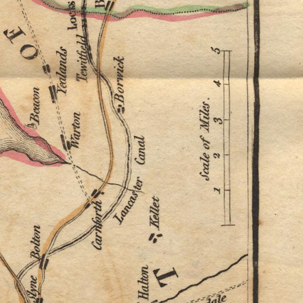 Ws02SD56.jpg
 |
Borwick -- building/s -- SD5273
Carnforth -- building/s -- SD499705 Keer, River -- river -- SD5573 (etc) Lancaster Canal -- canal etc -- SD58 (etc) Over Kellet -- building/s -- SD5269 Tewitfield -- building/s -- SD5273 Warton -- building/s -- SD5072 Yealands Conyer -- building/s -- SD5074 | |
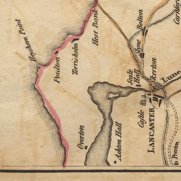 Ws02SD45.jpg
 |
Ashton Hall (?) -- building/s -- SD4657
Bolton-le-Sands -- building/s etc -- SD4766 Heysham Point (?) -- headland -- SD4061 Heysham -- building/s -- SD4061 Lancaster Canal -- canal etc -- SD58 (etc) Lancaster Castle -- castle -- SD473619 Lune Estuary -- estuary -- river estuary -- SD45 (etc) Overton -- building/s -- SD4457 Poulton -- building/s etc -- SD4564 (roughly) Scale Hall -- building/s -- SD4662 Slyne -- building/s -- SD4857 St Mary's Church -- church -- SD474619 Torrisholme -- building/s -- SD4564 | |
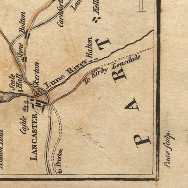 Ws02SD55.jpg
 |
Helton -- building/s -- SD5064
Lancaster Canal -- canal etc -- SD58 (etc) Lancaster -- building/s -- SD476616 Lune Aqueduct -- canal aqueduct -- aqueduct -- SD4863 Lune, River -- river etc -- NY6205 (etc) Skerton -- building/s -- SD4763 | |
 Lakes Guides menu.