 Otley 1818 map
 |
 |
|
|
Places Identified
Map, uncoloured engraving, The District of the Lakes, Cumberland, Westmorland, and Lancashire, scale about 4 miles to 1 inch, by Jonathan Otley, 1818, engraved by J and G Menzies, Edinburgh, Scotland, published by Jonathan Otley, Keswick, Cumberland, et al, 1833. NB: each image includes an overlap, places in the overlap are not listed. The images are roughly equivalent to ngr 10Km squares and are listed from top left to bottom right. | ||
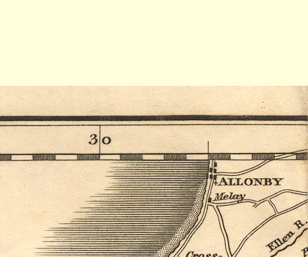 OT02NY04.jpg
 |
Allonby -- building/s -- NY0843
Mealo House -- building/s -- NY0741 | |
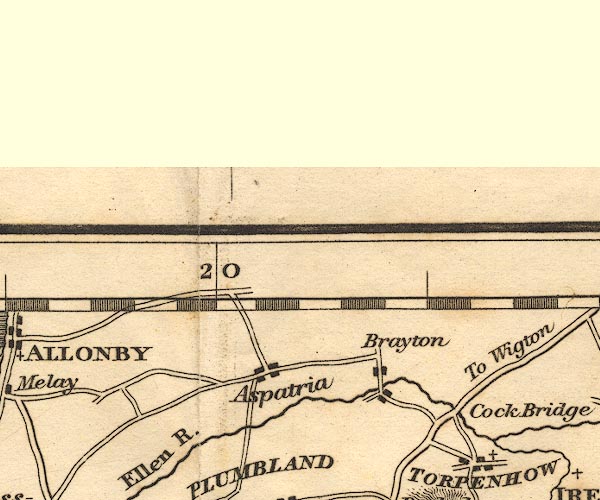 OT02NY14.jpg
 |
Aspatria -- building/s -- NY1441
Brayton -- locality -- NY1642 Cock Bridge -- bridge -- NY198410 | |
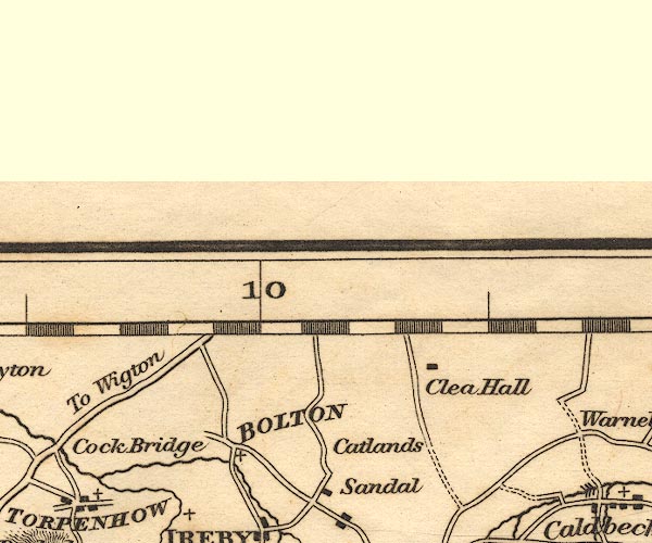 OT02NY24.jpg
 |
Bolton Low Houses -- building/s -- NY2344
Catlands Hill -- hill -- NY2441 Clea Hall -- building/s -- NY2742 | |
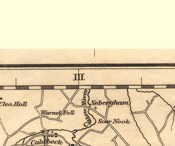 OT02NY34.jpg
 |
Caldew, River -- river etc -- NY3851 (etc) ?
Sebergham Bridge -- bridge -- NY35724184 Sebergham -- building/s -- NY357418 Sour Nook -- building/s -- NY3740 Warnell Fell -- hill -- NY3341 | |
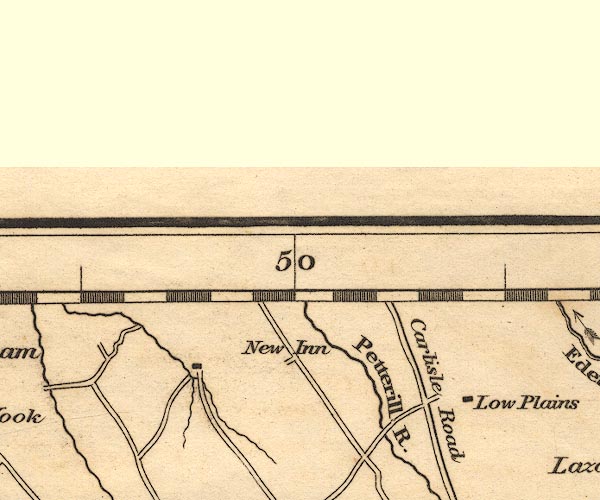 OT02NY44.jpg
 |
Low Plains -- building/s -- NY495416
New Inn -- inn -- NY4542 (guess) Petteril, River -- river -- NY4935 (etc etc) | |
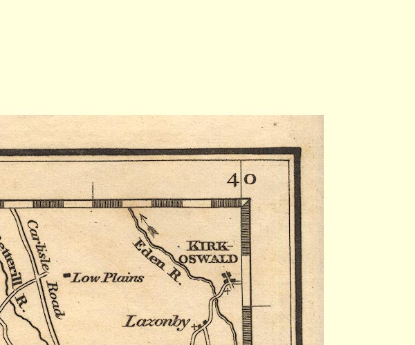 OT02NY54.jpg
 |
Eden, River -- river etc -- NY3658 (etc)
Kirkoswald -- building/s -- NY5541 | |
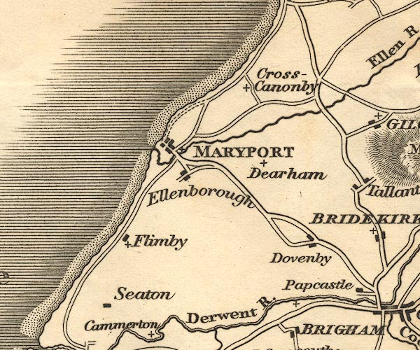 OT02NY03.jpg
 |
Crosscanonby -- building/s -- NY0738 ?
Dearham -- building/s -- NY0736 Dovenby -- building/s -- NY0933 Ellenborough -- building/s -- NY0435 Flimby -- building/s -- NY0233 ? Maryport -- building/s -- NY037366 Seaton -- building/s -- NY0130 | |
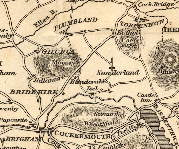 OT02NY13.jpg
 |
Blindcrake -- building/s -- NY1434
Bothel -- building/s -- NY1838 Bridekirk -- building/s -- NY1133 Caer Mote -- hill -- NY1937 Cockermouth -- building/s etc -- NY122306 Derwent Bridge -- bridge -- NY118307 ? Ellen, River -- river etc -- NY2436 (etc) Gilcrux -- building/s -- NY1138 Isel -- locality -- NY1633 Moota Hill -- hill -- NY1436 Ouse Bridge -- bridge -- NY199321 Papcastle -- building/s -- NY1031 Peelewike -- building/s -- house -- NY199307 Plumbland -- building/s -- NY1539 Setmurthy -- locality -- NY1832 Sunderland -- building/s -- NY1735 Tallentire -- building/s -- NY1035 Torpenhow -- building/s -- NY2039 Wheat Sheaf -- inn -- NY1730 (guess) | |
 OT02NY23.jpg
 |
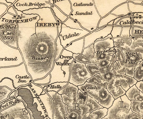
Bassenthwaite Lake -- lake -- NY215298
Bassenthwaite -- building/s -- NY2332 Binsey -- hill -- NY2235 Brae Fell -- hill -- fell -- NY2835 Castle Inn -- inn -- NY214327 Dash -- building/s -- NY2632 Ireby -- building/s etc -- NY238388 Little Tarn -- lake -- NY249338 Over Water -- lake -- NY251350 Sandale -- building/s -- NY2440 Uldale -- building/s -- NY2436 | |
 OT02NY33.jpg
 |
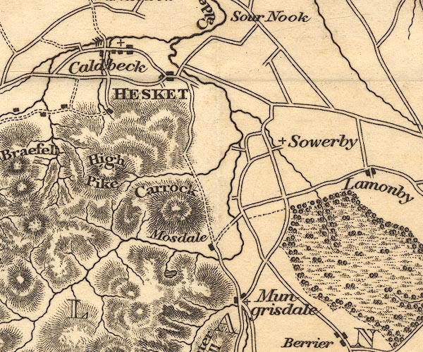
Bowscale Tarn -- lake -- NY3331
Caldbeck -- building/s -- NY3239 Carrock Fell -- hill -- fell -- NY3433 Greystoke Castle -- castle -- park -- NY425309 (castle) Hesket Newmarket -- building/s etc -- NY340386 High Pike -- hill -- NY319349 Mosedale -- building/s -- NY3532 ? Mungrisdale -- building/s -- NY3630 Sowerby Hall -- building/s -- NY3836 | |
 OT02NY43.jpg
 |
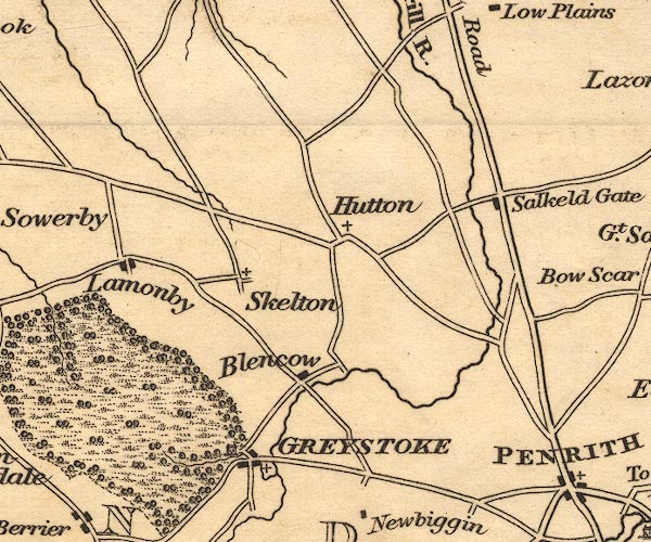
Blencow -- building/s -- NY4532
Greystoke Castle -- castle -- park -- NY425309 (castle) Greystoke -- building/s -- NY4330 Hutton-in-the-Forest -- building/s -- NY460358 Lamonby -- building/s -- NY409358 Plumpton Wall -- building/s -- NY497371 Skelton -- building/s -- NY4335 | |
 OT02NY53.jpg
 |
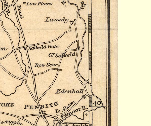
Bowscar -- building/s -- NY5134
Edenhall -- building/s -- NY565324 Great Salkeld -- building/s -- NY5536 Lazonby -- building/s -- NY5439 Penrith -- building/s etc -- NY513304 | |
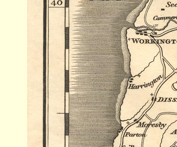 OT02NX92.jpg
 |
Harrington -- building/s -- NX9825
Moresby -- building/s -- NX9921 Parton -- building/s -- NX9720 Workington -- building/s -- NX996288 | |
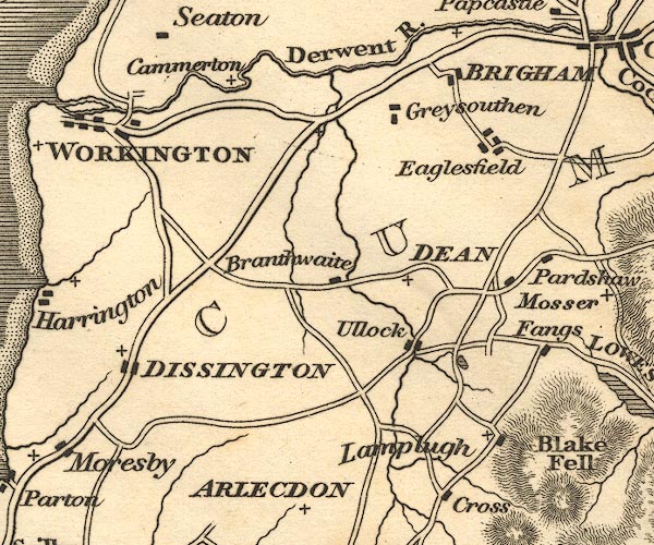 OT02NY02.jpg
 |
Branthwaite -- building/s -- NY0524
Brigham -- building/s -- NY0830 Camerton -- building/s -- NY0330 ? Dean -- building/s -- NY0725 Derwent, River -- river etc -- NY2515 (etc) ? Distington -- building/s -- NY0023 Eaglesfield -- building/s -- NY0928 Fangs -- building/s -- NY1022 Greysouthen -- building/s -- NY0728 Lamplugh -- building/s -- NY088207 Ullock -- building/s -- NY0723 | |
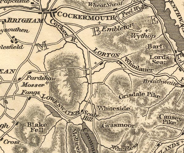 OT02NY12.jpg
 |
Blake Fell -- hill -- fell -- NY1019
Cocker, River -- river -- NY1426 ? Embleton -- building/s -- NY1730 Grasmoor -- hill -- NY17492034 Grisedale Pike -- hill -- NY19852256 (?) High Lorton -- building/s -- NY162257 Loweswater -- lake -- NY125217 ? Mosser -- NY114247 Pardshaw -- building/s -- NY0924 Scale Hill -- building/s -- NY150216 Whinlatter Pass -- pass -- NY1924 Whiteside -- hill -- NY17042195 Wythop -- locality -- NY203284 (etc) | |
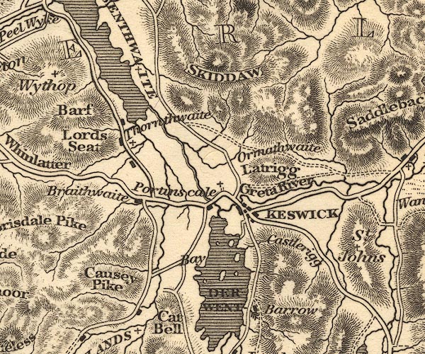 OT02NY22.jpg
 |
Barf -- hill -- NY21452674
Barrow -- hill -- NY22702181 Bassenthwaite Lake -- lake -- NY215298 Braithwaite -- building/s -- NY231235 Castlerigg -- building/s -- NY281224 Causey Pike -- hill -- NY21872085 Derwent Bay -- bay -- NY252214 Derwent Bridge -- bridge -- NY25112400 Derwent Water -- lake etc -- NY260210 ? Greta Bridge -- bridge -- NY26302374 ? ? Greta, River -- river -- NY2924 Keswick -- building/s etc -- NY266234 Latrigg -- hill -- NY279247 Lord's Seat -- hill -- NY204265 Newlands Beck -- river -- NY2319 Ormathwaite -- building/s -- NY267254 Portinscale -- building/s -- NY251235 Skiddaw -- hill -- NY260290 St Kentigern's Church -- church -- NY25652431 station, Skiddaw -- viewpoint -- station -- NY260290 Thornthwaite -- building/s -- NY223254 ? | |
 OT02NY32.jpg
 |
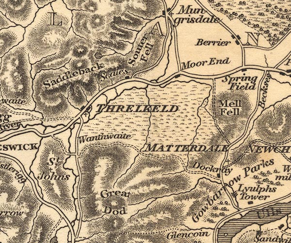
Aira Beck -- river -- NY40001974
Aira Force -- waterfall -- NY39952048 Berrier -- building/s -- NY4029 Dacre Beck -- river -- NY4626 Dockray -- building/s -- NY392216 Gowbarrow Park -- park -- NY408212 (etc) Great Dodd -- hill -- NY34192056 Great Mell Fell -- hill -- NY396672538 Matterdale -- locality -- NY3922 (?) Moorend -- building/s -- NY40452310 Saddleback -- hill -- NY3127 (etc) Scales Tarn -- lake -- NY328281 Scales -- area -- NY342269 Souther Fell -- hill -- fell -- NY352287 (etc) Springfield -- locality -- NY405279 St John's Beck -- river -- NY3123 ? Threlkeld -- building/s -- NY322254 Wanthwaite -- building/s -- NY318229 | |
 OT02NY42.jpg
 |
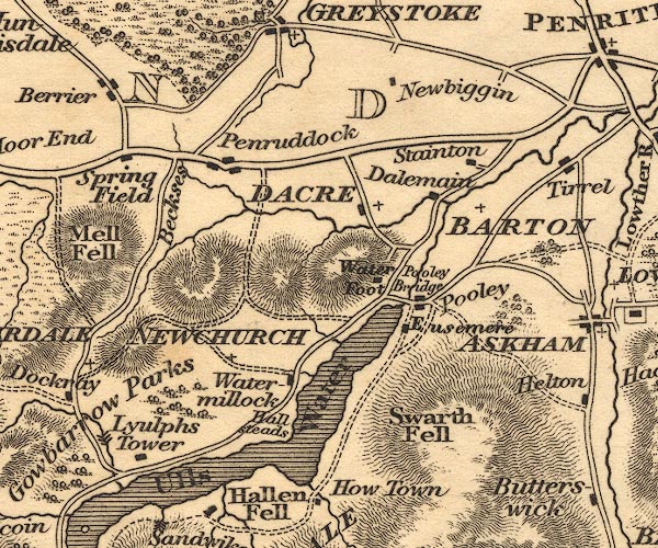
Barton -- building/s -- NY486264
Beckces -- building/s -- NY417277 Dacre -- building/s -- NY459265 Dalemain -- park -- house -- museum -- NY479269 Eusemere -- building/s -- NY46942411 Hallsteads -- building/s -- NY43812114 Lyulph's Tower -- tower -- NY40412020 Newbiggin -- building/s -- NY4629 Newchurch -- locality -- NY4323 (etc) Penruddock -- building/s -- NY429276 Pooley Bridge -- bridge -- NY47002442 Pooley Bridge -- building/s etc -- NY472244 Stainton -- building/s -- NY4827 Swarth Fell -- hill -- fell -- NY451198 Ullswater -- lake -- NY422202 (etc) ? Waterfoot -- building/s -- NY46042458 Watermillock -- building/s -- NY445224 | |
 OT02NY52.jpg
 |
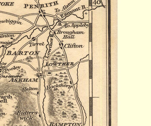
Askham -- building/s -- NY513237
Brougham Castle -- castle -- NY537290 ? Brougham Hall -- building/s -- NY52822839 ? Clifton -- building/s -- NY534266 Eamont Bridge bridge -- bridge -- NY52202875 Eamont, River -- river etc -- NY469243 (from) ? ? Hackthorpe -- building/s -- NY542232 Helton -- building/s -- NY510220 Lowther Bridge -- bridge -- NY524282 ? Lowther Castle -- castle -- NY523238 Lowther -- building/s -- NY536236 Lowther, River -- river etc -- NY5124 (etc) ? St Ninian's Church -- church -- NY55932995 Tirril -- building/s -- NY5026 | |
 OT02NX91.jpg
 |
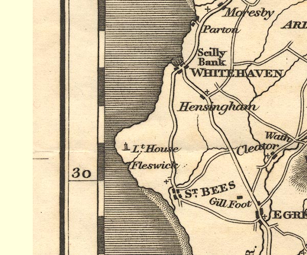
Gillfoot -- building/s -- NY0011
Hensingham -- building/s -- NX9816 Scilly Bank -- building/s -- NX9919 St Bees Head -- headland -- NX9412 St Bees Lighthouse -- lighthouse -- NX94151437 St Bees -- building/s -- NX971116 Whitehaven -- building/s -- NX974182 | |
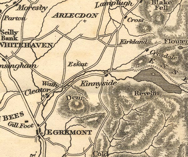 OT02NY01.jpg
 |
Arlecdon -- building/s -- NY0419
Cleator -- building/s -- NY0113 Crag Fell -- hill -- fell -- NY097143 Croasdale -- building/s -- NY093174 Dent -- NY0313 Egremont -- building/s -- NY011105 Ennerdale Water -- lake -- NY106150 Eskett -- building/s -- NY0516 Kinniside -- locality -- NY1213 (area) Kirkland -- building/s -- NY0717 Lamplugh Cross -- road junction -- junction -- NY076199 Revelin Crag -- rocks -- NY093147 Wath Brow -- building/s -- NY0214 | |
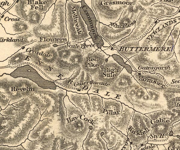 OT02NY11.jpg
 |
Buttermere -- lake -- NY182158
Buttermere -- building/s -- NY175169 Crummock Water -- lake -- NY158189 Ennerdale Water -- lake -- NY106150 Ennerdale -- valley -- NY11 Floutern Tarn -- lake -- NY124170 Gatesgarth -- building/s -- NY194149 Gillerthwaite -- building/s -- NY14372102 Haycock -- hill -- NY144471071 High Stile -- hill -- NY169147 Honister Crag -- rocks -- NY211143 Kirk Fell -- hill -- fell -- NY19491049 Mellbreak -- hill -- NY145190 ? Pillar -- hill -- NY17121211 Red Pike -- hill -- NY16051545 Scale Force -- waterfall -- NY150170 Scoat Tarn -- lake -- NY159103 Whiteless Pike -- hill -- NY180189 | |
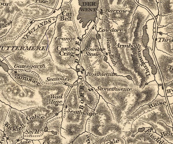 OT02NY21.jpg
 |
Armboth -- locality -- NY305171
Wad, The -- black lead mine -- mine -- plumbago mine -- adit -- NY235127 Blea Tarn -- lake -- NY291140 Borrowdale -- locality -- valley -- NY2516 (etc) Bowder Stone -- stone -- NY25391640 Castle Crag -- rocks -- NY249159 Cat Bells -- hill -- NY24401986 Grange -- building/s -- NY252174 Great Gable -- hill -- NY21101034 Lodore -- locality -- NY2618 Newlands Valley (?) -- valley -- NY2319 (etc) Rosthwaite -- building/s -- NY259149 ? Seathwaite -- building/s -- NY235122 Seatoller -- building/s -- NY244137 Stonethwaite -- building/s -- NY262137 Taylorgill Force -- waterfall -- NY229109 ? Seathwaite to Wasdale Head -- track -- route -- NY2312 & NY2310 & NY2210 & NY2209 & NY2109 & NY2009 & NY1909 & NY1809 & NY1808 Watendlath Beck -- river -- NY2717 Watendlath Tarn (?) -- building/s -- NY275161 Watendlath -- building/s -- NY276163 waterfall, Seathwaite Slabs -- waterfall -- NY230122 (?) | |
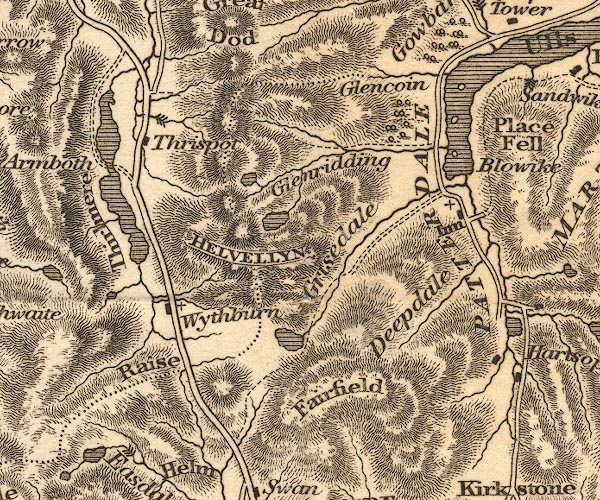 OT02NY31.jpg
 |
Blowick -- building/s -- NY39481738
Deepdale -- valley -- NY3913 Dunmail Raise -- hill -- NY327117 Fairfield -- hill -- NY35871176 Fisherplace Gill -- river -- NY3218 Glencoynedale -- valley -- NY3718 (etc) ? Glenridding -- building/s -- NY386170 (etc) Grisedale Tarn -- lake -- NY348120 ? Grisedale -- valley -- NY3715 (etc) Helvellyn -- hill -- NY34261508 Keppelcove Tarn -- lake (gone) -- NY346165 Patterdale Hotel -- inn -- NY39561589 ? Patterdale -- building/s -- NY394160 Raise Beck -- river -- NY3211 Red Tarn -- lake -- NY347152 station, Helvellyn -- viewpoint -- station -- NY342150 Thirlmere -- lake -- NY3115 (etc) ? Thirlspot -- building/s -- NY317177 Ullswater -- lake -- NY422202 (etc) ? waterfall, Fisher Gill -- waterfall -- NY321182 Wythburn -- locality -- NY322130 (etc) | |
 OT02NY41.jpg
 |
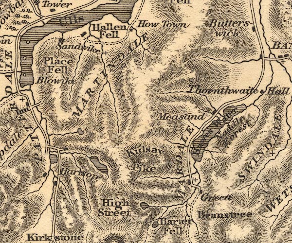
Angle Tarn -- lake -- NY417143
Blea Water -- lake -- NY448107 Brothers Water -- lake -- NY402127 ? Hallin Fell -- hill -- fell -- NY43301982 Hartsop -- building/s -- NY408131 ? ? Hawes Water -- lake -- reservoir -- NY4713 (etc) Hayeswater -- lake -- NY431121 ? High Street -- hill etc -- NY441111 (etc) Holy Trinity Church -- church (flooded) -- NY475117 Howtown -- building/s -- NY443195 ? Kidsty Pike -- hill -- NY44731260 Mardale Common -- common -- NY485115 (etc) Mardale -- valley -- NY4712 (roughly) Martindale -- locality -- NY4318 Measand -- locality -- NY4815 Naddle Forest -- forest -- NY495145 (etc) ? Place Fell -- hill -- NY40561696 Sandwick -- building/s -- NY42351982 | |
 OT02NY51.jpg
 |
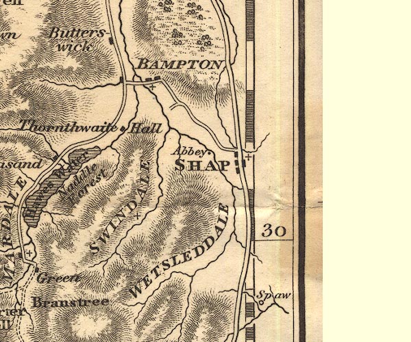
Bampton Grange -- building/s -- NY521180 ?
church, Swindale -- church -- school -- NY51311309 Shap Abbey -- abbey -- religious house -- NY548153 Shap -- building/s etc -- NY562153 Spa Well -- spring -- spa -- NY5709 ? Swindale -- valley -- NY5113 (etc) Thornthwaite Hall -- building/s -- NY512163 Wet Sleddale -- valley -- NY5411 (etc) | |
 OT02NX90.jpg
 | ||
 OT02NY00.jpg
 |
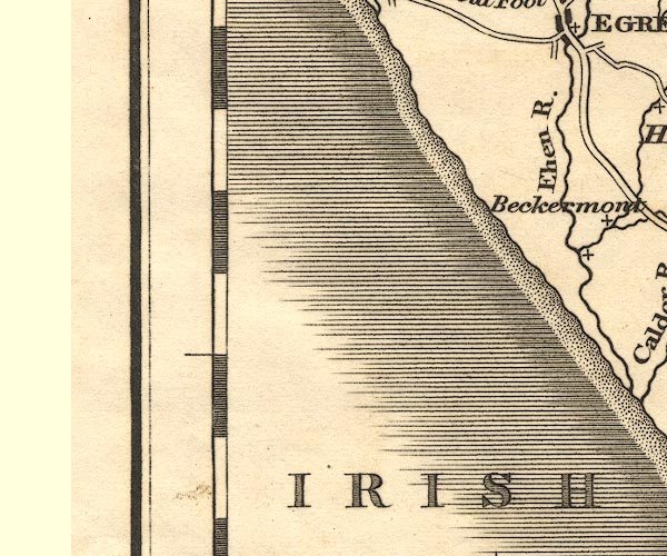
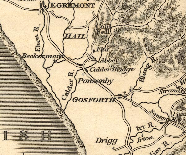
Abbey Flatts -- building/s -- NY051071
Beckermet -- building/s -- NY0106 Bleng, River -- river -- NY1108 Calder, River -- river etc -- NY0712 (etc) ? Cold Fell -- hill -- fell -- NY05820919 Ehen, River -- river -- NY0515 (etc) ? Gosforth -- building/s -- NY070035 Haile -- building/s -- NY0308 Irt, River -- river etc -- NY1002 (etc) ? Irton -- locality -- NY1000 Ponsonby -- building/s -- NY054055 | |
 OT02NY10.jpg
 |
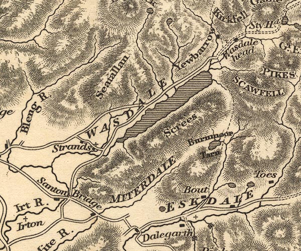
Blea Tarn -- lake -- NY165010
Boot -- building/s -- NY176010 Burnmoor Tarn -- lake -- NY183043 ? Eel Tarn -- lake -- NY189019 Eskdale -- valley -- locality -- NY1802 (etc) Miterdale -- valley -- NY1501 Santon Bridge (?) -- bridge -- NY11020161 Santon Bridge -- building/s -- NY110016 Screes, The -- scree -- NY1504 Seatallan -- hill -- NY13960841 Stony Tarn -- lake -- NY199024 Strands -- building/s -- NY124040 Wasdale Head -- building/s -- NY186088 Wast Water -- lake -- NY161059 Yewbarrow -- hill -- NY173085 | |
 OT02NY20.jpg
 |
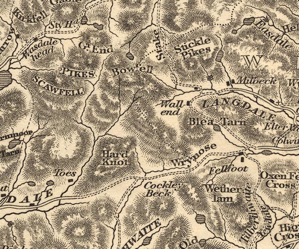
Angle Tarn -- lake -- NY244076
Blea Tarn -- lake -- NY292043 Bow Fell -- hill -- fell -- NY24460645 Cockley Beck -- building/s -- NY247016 Codale Tarn -- lake -- NY296088 Dungeon Ghyll Force -- waterfall -- NY290065 Fell Foot -- building/s -- NY29890319 Great End -- hill -- NY225084 Great Langdale -- valley -- NY3006 (etc) Hard Knott -- hill -- NY23180237 Levers Water -- lake -- SD279992 Millbeck -- locality -- NY295066 Pike of Stickle -- hill -- NY27390736 Sca Fell -- hill -- NY20680651 (?) Scafell Pike -- hill -- NY21550722 Sprinkling Tarn -- lake -- NY228091 Stake Pass -- pass -- NY26530869 (pile of stones) station, Scafell Pike -- viewpoint -- station -- NY2107 Stickle Tarn -- lake -- NY287076 Styhead Tarn -- lake -- NY221098 Taw House -- building/s -- NY210016 Seathwaite to Wasdale Head -- track -- route -- NY2312 & NY2310 & NY2210 & NY2209 & NY2109 & NY2009 & NY1909 & NY1809 & NY1808 Wall End -- building/s -- NY28300553 Wetherlam -- hill -- NY28780109 (?) Wrynose Pass -- pass -- NY27700270 | |
 OT02NY30.jpg
 |
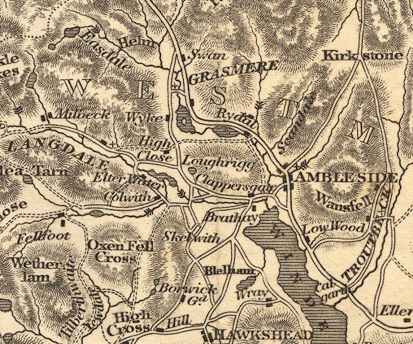
Ambleside -- building/s etc -- NY376045 ?
Blelham Tarn -- lake -- NY365004 Borwick Lodge -- building/s -- SD342995 Brathay Hall -- building/s -- NY36660312 Brathay, River -- river -- NY3503 Calgarth Hall -- building/s -- SD398996 ? Chapel Stile -- building/s -- NY317054 Clappersgate -- building/s -- NY366033 Colwith Force -- waterfall -- NY32790313 Colwith -- building/s -- NY330031 Easedale Tarn -- lake -- NY307087 (etc) Easedale -- valley -- NY3208 Elter Water -- lake -- NY333041 Grasmere -- lake -- NY337066 Grasmere -- building/s -- NY336075 ? Helm Crag -- hill -- NY32670930 High Close -- building/s -- NY338053 High Fall -- waterfall -- NY365068 Little Langdale Tarn -- lake -- NY309032 Loughrigg Fell -- hill -- fell -- NY3405 Loughrigg Tarn -- lake -- NY344043 Low Wood -- building/s etc -- NY39400156 Oxen Fell -- hill -- fell -- NY3202 Pelter Bridge -- bridge -- NY36600594 Rydal Water -- lake -- NY355061 Rydal -- building/s -- NY364062 Scandale Pass -- pass -- NY386095 Skelwith Bridge -- building/s -- NY344034 Skelwith Force -- waterfall -- NY34130342 Stock Ghyll -- river -- NY3905 Stockghyll Force -- waterfall -- NY382045 Swan Hotel -- inn (hotel) -- NY339083 Tarns, The -- lake -- SD330999 Tilberthwaite -- locality -- NY308012 (etc) Wansfell -- hill -- fell -- NY393043 (etc) Windermere -- lake -- SD392950 ? Wray Castle -- castle -- NY37490103 Wyke, The -- building/s -- NY33260653 (?) Yewdale -- valley -- SD3199 (etc) | |
 OT02NY40.jpg
 |
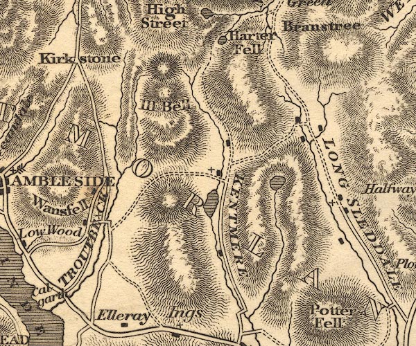
Harter Fell -- hill -- fell -- NY459093
Ill Bell -- hill -- NY43650774 Kentmere Tarn -- lake -- NY455028 (approx) Kentmere -- valley -- NY457040 (etc) Kirkstone Pass -- pass -- NY401080 Longsleddale -- valley -- NY4904 (etc) Sadgill -- locality -- NY482057 Skeggles Water -- lake -- NY479034 Small Water -- lake -- NY454100 Sprint, River -- river etc -- NY4806 (etc) Stockdale -- building/s -- NY49100530 ? Troutbeck Bridge -- bridge -- NY40310035 Troutbeck -- building/s -- NY4103 | |
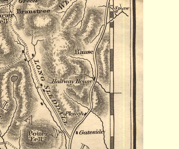 OT02NY50.jpg
 |
Bannisdale Beck -- river -- NY5202
Gateside -- building/s -- SD529994 Hucks Bridge Inn -- building/s -- inn (once) -- NY55250401 Hucks Bridge -- bridge -- NY552039 Longsleddale -- valley -- NY4904 (etc) Plough Inn -- inn -- NY534000 Kendal to Shap -- route -- road -- SD59 Sprint, River -- river etc -- NY4806 (etc) | |
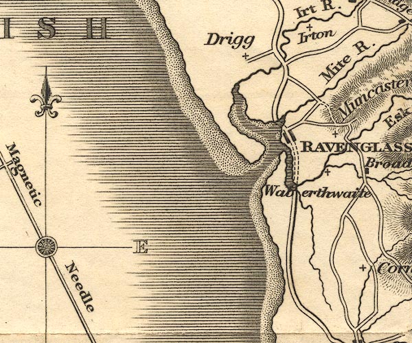 OT02SD09.jpg
 |
Drigg -- building/s -- SD0698
Mite, River -- river etc -- NY1602 Ravenglass -- building/s etc -- SD085964 Waberthwaite -- building/s -- SD104935 | |
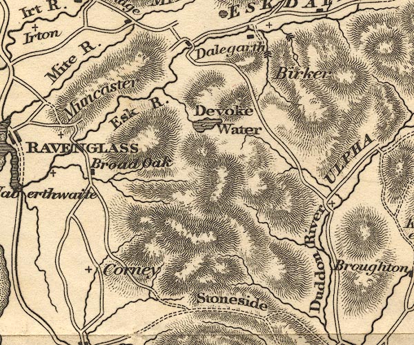 OT02SD19.jpg
 |
Birker Fell -- hill -- fell -- SD173975 (etc)
Birker Force -- waterfall -- SD18759993 (?) Broad Oak -- building/s -- SD114947 (?) Corney -- building/s -- SD115914 ? Dalegarth Hall -- building/s -- NY169001 ? Devoke Water -- lake -- SD158969 Duddon, River -- river etc -- NY2602 (etc) Esk, River -- river etc -- NY2101 (etc) ? Low Birker Tarn -- lake -- SD190995 Muncaster -- locality -- SD1296 Stanley Force -- waterfall -- SD17429948 (etc) Stoneside Hill -- hill -- SD145892 Ulpha -- building/s -- SD197932 (etc) | |
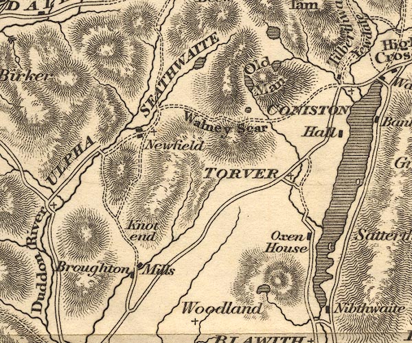 OT02SD29.jpg
 |
Beacon Tarn -- lake -- SD273900
Broughton Mills -- building/s -- SD222905 Coniston Hall -- building/s -- SD30449634 Coniston Water -- lake -- SD302943 Goat's Water -- lake -- SD266976 Knott End -- building/s -- SD222915 ? Low Water -- lake -- SD274982 Old Man of Coniston, The -- hill -- SD27239782 Oxen House -- building/s -- SD290921 Seathwaite Tarn -- lake -- SD253988 Seathwaite -- building/s -- SD227960 ? Torver -- building/s -- SD283941 Walna Scar -- hill -- SD256962 (etc) | |
 OT02SD39.jpg
 |
Belle Isle -- island -- SD393967 ?
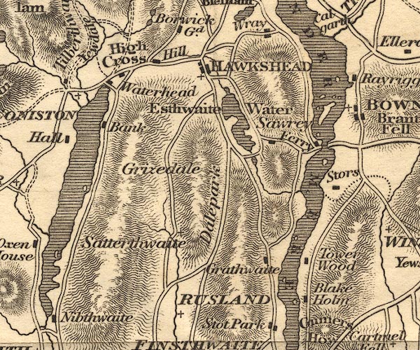
Blake Holme Plantation -- wood -- SD3989 (etc) Coniston Water -- lake -- SD302943 Coniston -- building/s -- SD302978 Dale Park -- park -- SD3592 (etc) Esthwaite Water -- lake -- SD3696 (etc) Far Sawrey -- building/s -- SD378954 Graythwaite Old Hall -- building/s -- SD372908 Hawkshead Hill -- building/s -- SD337987 Hawkshead -- building/s etc -- SD351980 High Bank Ground -- building/s -- SD31599703 High Cross -- SD33219862 Low Bank Ground -- building/s -- SD31599694 Near Sawrey -- building/s -- SD369956 Out Dubs Tarn -- lake -- SD367948 Rusland Cross -- building/s -- SD340888 Rusland -- area -- SD337894 Satterthwaite -- building/s -- SD338923 Storrs -- area -- SD3994 (etc) Tower Wood -- building/s -- SD386910 Waterhead -- building/s -- SD310975 Windermere Ferry, Windermere -- ferry -- SD39109569 & SD39579581 Windermere -- lake -- SD392950 ? | |
 OT02SD49.jpg
 |
Bowness-on-Windermere -- building/s -- NY403969 ? ?
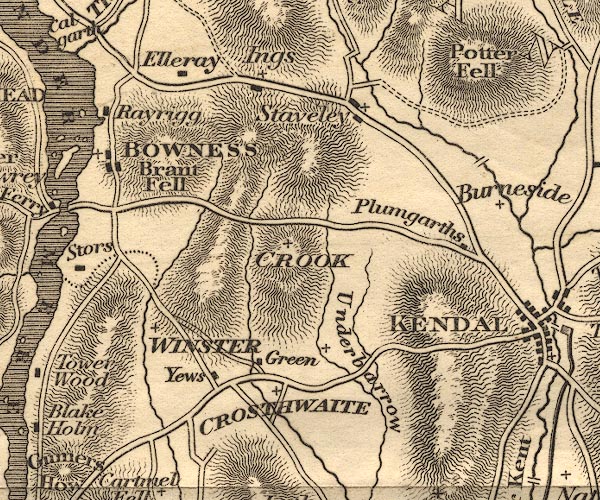
Brant Fell -- hill -- SD409961 bridge, Bowston -- bridge -- SD49869660 ? Crook -- building/s -- SD464951 Crosthwaite -- building/s -- SD437915 Dodds Howe -- building/s -- SD436916 (?) Elleray -- building/s -- SD411989 Ings -- building/s -- SD445986 Low Yews -- building/s -- SD428910 Plumgarths -- building/s -- SD493947 Potter Fell -- hill -- fell -- SD5099 & SD5199 Rayrigg Hall -- building/s -- SD402981 Staveley -- building/s etc -- SD470984 Underbarrow -- building/s -- SD465922 Winster -- building/s -- SD418935 | |
 OT02SD59.jpg
 |
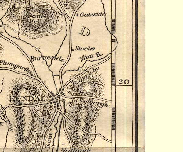
Burneside -- building/s -- SD5095
Canal Head -- canal wharf -- wharf -- SD519926 (approx) Kendal -- building/s etc -- SD514926 Lancaster Canal -- canal etc -- SD58 (etc) Laverock Bridge -- packhorse bridge -- bridge (ex) -- SD53569517 ? Miller Bridge -- bridge -- SD516926 Mint Bridge -- bridge -- SD52209426 ? Nether Bridge -- bridge -- SD516919 Stocks -- building/s -- SD529965 Stramongate Bridge -- bridge -- SD51859297 | |
 OT02SD08.jpg
 | ||
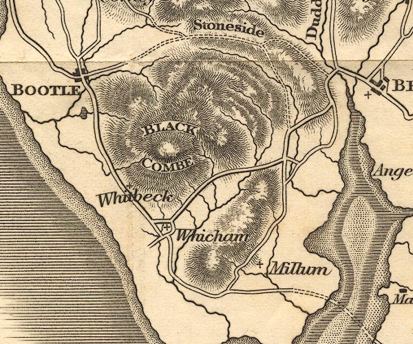 OT02SD18.jpg
 |
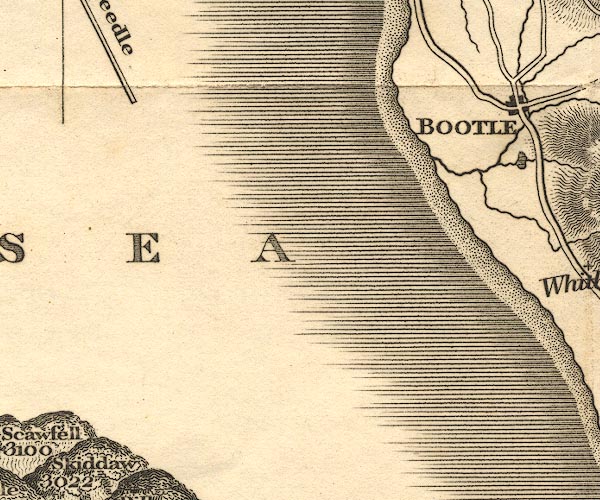
Barfield Tarn -- lake -- SD107869
Black Combe -- hill -- SD135855 (summit) Bootle -- building/s etc -- SD108883 Duddon Bridge -- bridge -- SD19928818 Millom -- building/s -- SD171801 Whicham -- building/s -- SD132825 Whitbeck -- building/s -- SD118845 | |
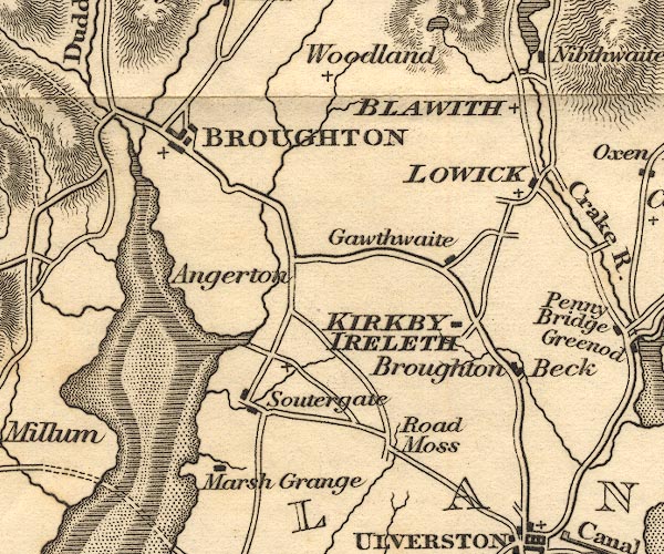 OT02SD28.jpg
 |
Angerton -- building/s -- SD2184
Blawith -- building/s -- SD288883 Broughton Beck -- building/s -- SD2883 Broughton in Furness -- building/s etc -- SD211876 Duddon Estuary -- estuary -- river estuary etc -- SD1475 (etc) Gawthwaite -- building/s -- SD271848 Kirkby -- SD2484 (area) Lowick -- building/s -- SD290860 (etc) Marsh Grange -- building/s -- SD220797 Rathmoss -- building/s -- SD2580 Soutergate -- building/s -- SD2281 Woodland -- building/s -- SD247890 | |
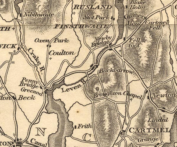 OT02SD38.jpg
 |
Backbarrow -- building/s -- SD357847
Bigland Tarn -- lake -- SD355828 Cartmel -- building/s -- SD382786 Colton -- building/s -- SD316860 Crake, River -- river etc -- SD2987 (etc) Fell Foot -- park -- SD3887 (etc) Finsthwaite -- building/s -- SD368878 Frith Hall -- building/s -- SD33827977 Greenodd -- building/s -- SD313825 Gummer's How -- hill -- SD39048848 High Frith -- building/s -- SD3380 High Stott Park -- building/s -- SD372885 ? Leven, River -- river etc -- SD3483 (etc) ? Low Frith -- building/s -- SD339796 Low Stott Park -- building/s -- SD372881 Newby Bridge -- building/s -- SD370865 Oxen Park -- building/s -- SD320871 Penny Bridge -- building/s -- SD309828 St Peter's Church -- church -- SD387817 Windermere -- lake -- SD392950 ? | |
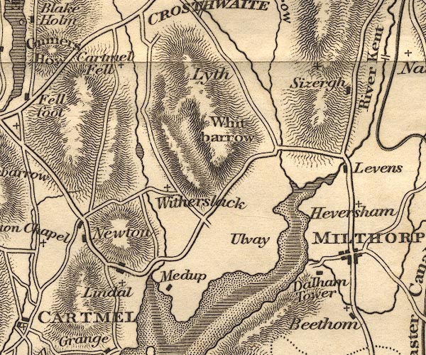 OT02SD48.jpg
 |
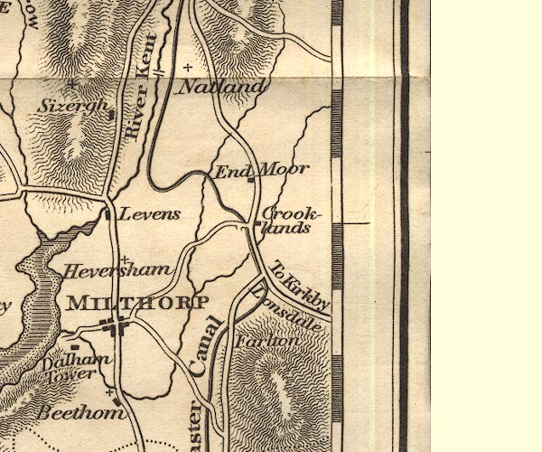
Beetham -- building/s -- SD4979
Cartmel Fell -- building/s -- SD415880 (etc) ? Dallam Tower -- building/s -- SD490810 Gilpin, River -- river etc -- SD4490 (etc) Helton Tarn -- lake -- SD419849 Heversham -- building/s -- SD497833 Levens Bridge -- bridge -- SD49618522 Levens Hall -- building/s -- house -- SD494850 Lindale -- building/s -- SD415805 Lyth, Crosthwaite and Lyth -- locality -- SD48 (? area) Meathop -- building/s -- SD4380 Milnthorpe -- building/s -- SD496815 Newton Fell -- hill -- fell -- SD4182 Sizergh Castle -- building/s -- house -- park -- SD4987 Ulpha -- building/s -- SD4581 Whitbarrow -- hill -- SD4486 (etc) Winster, River -- river -- SD4285 (etc) Witherslack -- building/s -- SD4383 | |
 OT02SD58.jpg
 |
Crooklands -- building/s -- SD5383
Endmoor -- building/s -- SD5385 Farleton Fell -- hill -- fell -- SD5480 ? Farleton Knott -- rocks -- SD5480 ? Force Bridge -- bridge -- SD50748684 Kent, River -- river etc -- NY4506 (etc) Lancaster Canal -- canal etc -- SD58 (etc) Natland -- building/s -- SD5289 | |
 OT02SD17.jpg
 |
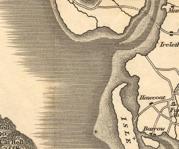
Duddon Estuary -- estuary -- river estuary etc -- SD1475
(etc)
Isle of Walney -- island -- SD1767 ? | |
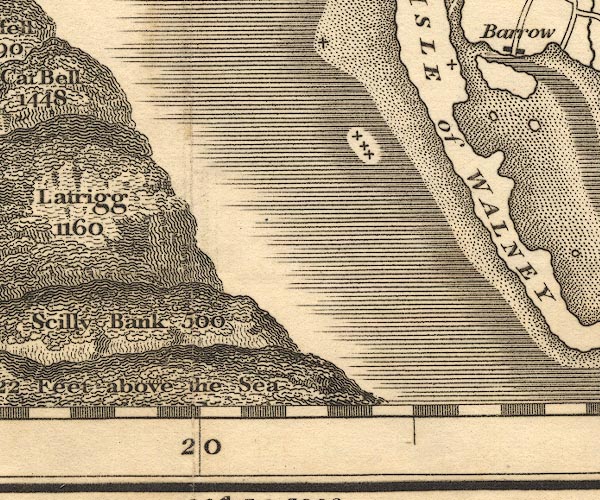
 OT02SD27.jpg
 |
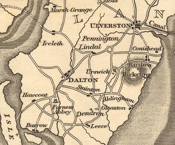
Aldingham -- building/s -- SD2871
Bardsea -- building/s -- SD3074 Barrow-in-Furness -- building/s -- SD198689 Birkrigg Common -- common -- SD2874 Dalton-in-Furness -- building/s -- SD227738 Dendron -- building/s -- SD246707 Furness Abbey -- abbey -- religious house -- SD218717 Gleaston -- building/s -- SD255707 Great Urswick -- building/s -- SD2674 Hawcoat -- building/s -- SD207720 (etc) Ireleth -- building/s -- SD2177 Isle of Walney -- island -- SD1767 ? Leece -- building/s -- SD2469 Lindal in Furness -- building/s -- SD2475 Pennington -- building/s -- SD2677 sands road, Duddon Sands -- sands road -- route -- SD27 Stainton with Adgarley -- building/s -- SD247724 Ulverston -- building/s -- SD289783 Urswick Tarn -- lake -- SD2774 | |
 OT02SD37.jpg
 |
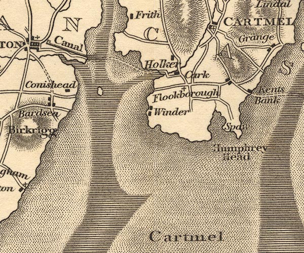
Cannon Winder -- building/s -- SD351746
Cark -- building/s -- SD363765 Chapel Island -- island -- SD311758 Flookburgh -- building/s -- SD3675 Holker -- building/s -- SD3677 Holy Well -- spring -- well -- spa -- SD39027391 Humphrey Head -- hill -- SD391738 Kent's Bank -- building/s -- SD397762 (etc) Leven Estuary -- estuary -- river estuary -- sea area -- SD3375 (etc) sands road, Leven Sands -- sands road -- route -- SD37 Ulverston Canal -- canal -- SD29397852 & SD31317768 | |
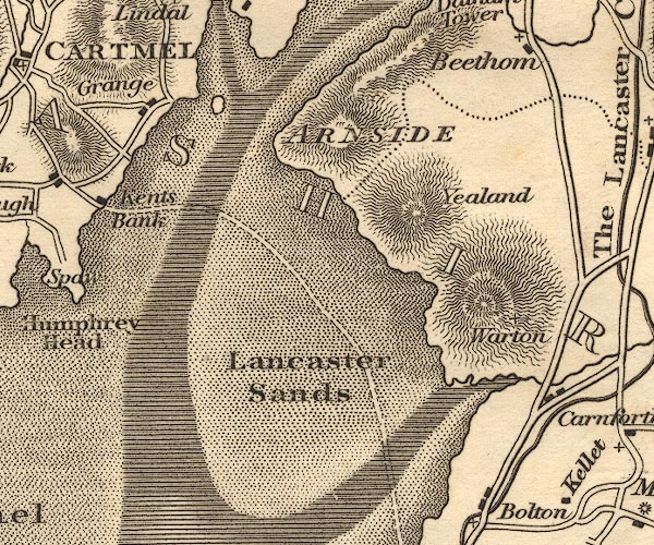 OT02SD47.jpg
 |
Arnside -- building/s -- SD456787
Grange-over-Sands -- building/s -- SD407778 Kent Estuary -- estuary -- river estuary -- sea area -- SD4377 (etc) Lancaster Canal -- canal etc -- SD58 (etc) Lancaster Sands -- sands -- foreshore -- SD47 (etc) sands road, Lancaster Sands -- sands road -- route -- SD47 Warton -- building/s -- SD5072 Yealands Conyer -- building/s -- SD5074 | |
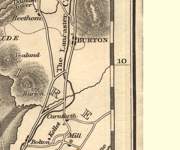 OT02SD57.jpg
 |
Burton-in-Kendal -- building/s -- SD531765
Carnforth -- building/s -- SD499705 Keer, River -- river -- SD5573 (etc) Lancaster Canal -- canal etc -- SD58 (etc) | |
 OT02SD16.jpg
 |
Isle of Walney -- island -- SD1767 ?
| |
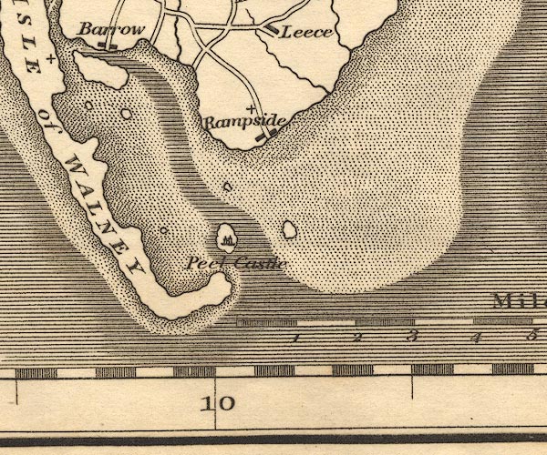 OT02SD26.jpg
 |
Piel Castle -- castle -- SD23306357
Piel Island -- island -- SD2363 Rampside -- building/s -- SD2466 | |
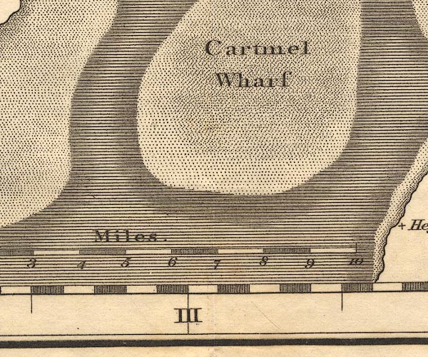 OT02SD36.jpg
 |
Cartmel Wharf -- sands -- SD3668 (etc etc)
| |
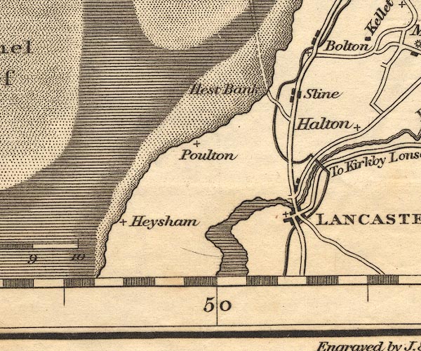 OT02SD46.jpg
 |
Bolton-le-Sands -- building/s etc -- SD4766
Helton -- building/s -- SD5064 Hest Bank -- building/s -- SD4766 Heysham -- building/s -- SD4061 Lancaster Canal -- canal etc -- SD58 (etc) Lancaster -- building/s -- SD476616 Lune Aqueduct -- canal aqueduct -- aqueduct -- SD4863 Poulton -- building/s etc -- SD4564 (roughly) Skerton Bridge -- bridge -- SD479622 Slyne -- building/s -- SD4857 | |
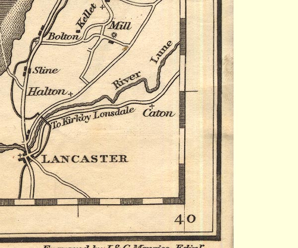 OT02SD56.jpg
 |
Caton -- building/s -- SD5464
Dunald Mill -- water mill -- mill -- SD516676 (?) Lune, River -- river etc -- NY6205 (etc) Over Kellet -- building/s -- SD5269 | |
 Lakes Guides menu.