 Morden 1695

|

|
|

|
back to object record | |
| MAP FEATURES | ||
|
|
||
|
title cartouche
scroll cartouche map maker publisher |
Printed in a prettily tinted scroll cartouche, upper
left:-
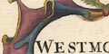
WESTMORLAND by Robt. Morden Printed lower right:- Sold by Abel Swale, Awnsham & John Churchill |
|
|
|
||
|
orientation
up is N |
The map is probably printed with compass North at the top
of the sheet. The scales of latitude and longitude suggest
that polar North is a few degrees anticlockwise from compass
North.
|
|
|
|
||
|
scale line
scale lines scale |
Printed lower left are three:-
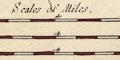
Scales of Miles Great / Middle / Small each chequered in miles, tinted red and white, labelled at 4 and 8. The 8 miles = 79.9 mm, 73.7 mm, 68.2 mm respectively. The average map scale, wrongly assuming a statute mile is:- 1 to 170000 2.5 miles to 1 inch |
|
|
|
||
|
lat and long
lat and long scales |
Printed in the map borders are scales of latitude and longitude for a slanted rectangular projection; chequered in minutes labelled at 10 minute intervals of longitude, 5 of latitude, tinted red and white. The upper longitude scale is labelled in roman numerals for the number of minutes of time later than London. From the scales can be read:- longitude, Kendal = 2d 25.5m W suggests a prime meridian nearly 20d West of Greenwich, which is unlikely. The map includes from about 1d 45m to 3d 5m W, from about 54d 10m to 54d 53m N; the whole of Westmorland. |
|
|
|
||
|
sea area
sea plain |
The very small sea area shown is plain, the Leven and
Kent estuaries.
|
|
|
|
||
|
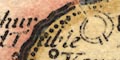
coast line
coast shaded foreshore |
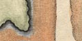
The small length of coast line is emphasised by shading, tinted blue. Foreshore shallows are dotted, perhaps engraved with a roulette. The dotting is closer at the edge of the area, which is tinted brown. The areas show conventional rather than accurate river channels. |
|
|
|
||
|
rivers
bridges |
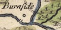
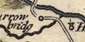
Rivers are drawn by a double wiggly line, tinted blue, or tapering single wiggly line. A wide reach, the Leven at New Bridge for example, might have form lines. Larger tributaries and feeders to lakes are shown. Some rivers are labelled, eg:- Winster flu Can Flu Blenkern beck R. Birkbeck Eden R Do not rely on consistent spelling, for example:- Lune Flu / Lone Flu Lowther R / Low Flu Bridges are implied where a road crosses and interrupts a stream, for example at Burrow bridge on the Kendal to Shap road. But notice that the engraving of road and river might just intersect, as on the Sprint east of Burneside, or the river might interrupt the road as on the Eden by Temple Sowerby. I would not jump to any conclusions about which are bridges and which are fords. Bridges might be drawn where no road is shown, and perhaps labelled, eg:- 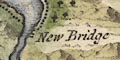
New Bridge |
|
|
|
||
| lakes |
Lakes are drawn in outline, the shore shaded, interior
engraved with a water effect, tinted blue. Notice Broadwater
which is engraved over and round the mountains at its south
end (and anyway it's Haweswater). Some lakes are
labelled:-
Ulles Flu Hawswater [Hayeswater] Broadwater [Haweswater] Winander Mere Other lakes, including some in adjacent counties, can be recognised:- Brotherswater Thirlmere [labelled as the head of the Derwent] Rydal Water [with a large island] Grasmere [smaller, no island] Easedale Tarn [perhaps] Coniston Water Kentmere Tarn As well as the large island in Rydal water, a whole lot of islands are drawn in Windermere lake. |
|
|
|
||
|
relief
hillocks |
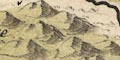
Relief is indicated by moderate size hillocks, shaded to the east, tinted pale brown. Some hillocks are drawn larger, for example at Farleton Knott and Whinfell. The hills are clustered in central lakeland and the Pennines, river plains left clear. Although the overall effect is attractive it is not truly informative. Some hills are labelled, eg:- Farleto~ Knothill Whinfield hill Helvillin hill Cross fell Murton Pike A pass might be labelled, as at:- Horse Hause This provides a different slant on the interpretation of 'Horse House' on other maps, which could otherwise be understood as Hause House. Notice also:- Lawsdale Horse north of Selside. |
|
|
|
||
|
woods
trees forests |
Groups of tree symbols, the area tinted green, indicate
woodland. Some groups might be labelled, eg:-
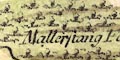
Mallerstang Forrest Whinfeild Forrest And some unlabelled groups might, cautiously, be recognised, for example fell Foot at the south end of lake Windermere. Trees are drawn in most parks. |
|
|
|
||
| parks |
Parks are drawn by an outline with fence palings,
interior with trees and undergrowth, tinted pale green. Some
parks are labelled, eg;-
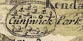
Cunswick Park Gowburrow Park Or the park might be recognised by a house or a settlement, as at Lowther. |
|
|
|
||
| county |
County boundaries are a bold dotted line, the inner side of each county tinted palely: Westmorland yellow, Cumberland pink, Lancashire green, Yorkshire ?brown. Durham is not shown. Adjacent counties are labelled, eg:- PART OF CUMBERLAND PART OF YORK SHIRE The county boundary is drawn alongside other features where necessary, for example along the River Winster. Windermere is entirely within Westmorland, the boundary following the shore. Ullswater is divided with Cumberland. |
|
|
|
||
| settlements |
Settlements are positioned by a circle with added
elements, differentiated by style of labelling. Towns are
tinted red.
|
|
| towns |
circle, buildings and towers, tinted red; labelled in
upright lowercase text, eg:-
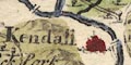
Kendall ABALLABA / Apalby Ambleside / Amboglana The extra placename is the name of the roman town. Notice a neat example of an engraver's correction where the o of Amboglana has been added above. |
|
| villages |
circle, building with tower; labelled in italic lowercase
text, eg:-
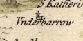
Underbarrow Great Asby Wetsleddale |
|
| hamlets |
circle; labelled in italic lowercase text, eg:-
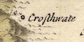
Crosthwate Caber Witherslack Ravingstondale or Russendale |
|
| houses |
circle and tower, or circle; labelled in italic lowercase
text, eg:-
Kendale castle Grarigg Hall |
|
|
Notice a series of re-engraved placenames south west of
Orton and other instances of re-engraving.
|
||
|
|
||
| roads |
A few roads are drawn by a double line, for example:- From the south, Lancaster, Lancashire; to Kendal by Burton or Farleton, then Shap, Westmorland; to Penrith, Cumberland. labelled:- From Lancaster to Kendall and Apalby though the route to Appleby is via Penrith. This is part of the London to Carlisle road plotted by John Ogilby. Other roads are shown and labelled, sometimes incorrectly. More notes on the Westmorland and Cumberland roads on Robert Morden's maps:- MD10Rod.txt MD16Rod.txt MD12Rod.txt |
|
|
|
||
| miscellany | ||
|
|
||
| beacons |
A beacon is carefully drawn, post, ladder, fire basket,
on a hillock labelled:-
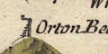
Orton Beacon Also labelled is:- Penrith Beacon but with no apparatus. |
|
|
|
||
|
mines
copper mines |
West of Great Langdale is:-
the Coper mines |
|
|
|
||
| stones |
A group of stones on the county boundary are
labelled:-
Dunmalrase Stones South of Shap are:- 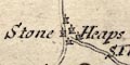
Stone Heaps marked by circle with tiny towers? Where the boundaries of Westmorland, Lancashire and Yorkshire meet a stone is drawn, labelled:- The County Stone At the road junction S of Tebay is:- Brandreth Stone |
|
|
|
||
| wells |
Labelled by Patterdale is:-
St Patricks well |
|
|
|
||
| crosses |
Notice Cross fell on the border north of Milborne
Forest.
An indeterminate mark east of Stainmore is labelled:- Rear Cross als Roycross A cross (+) is marked NE of Pendragon castle, labelled:- Hoomill Cross |
|
|
|
||
|
antiquities
earthworks |
A double ring with an entrance to the south. at Eamont
Bridge, is labelled:-
King Arthur round Table |
|
|
|
||
|
antiquities
roman sites roman towns |
Some roman placenames are given:-
Vertara [Brough Castle] ABALLABA [Appleby] Amboglana [Ambleside] Catadupa [waterfall, Levens] |
|
Lakes Guides menu.