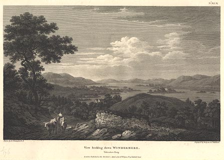
 View looking down Windermere, taken above Rarig

|

|
|
|
item:- Dove Cottage : Lowther.10 image:- © see bottom of page |
click to enlarge |
|
|
Print, engraving, View looking down Windermere, taken
above Rarig ie Rayrigg, Lakes, Cumbria, painted by Joseph
Farington, engraved by W Byrne and T Medland, published by W
Byrne, 69 Titchfield Street, London, 1789.
A farmer on horseback drives cattle up Rayrigg Bank in the foreground, Belle Isle is clear in the lake. Plate 19 from Views of the Lakes, &c, in Cumberland and Westmorland, published 1789. Pasted in the Lowther scrapbook, vol.1; between pp.180-181; with descriptive text:- VIEW looking down WINDERMERE from above RARIG. / THIS View comprehends the Lower Reach of Windermere looking towards the South, and is the Reverse of that given from Gill-Head. The Lakes here assumes the Appearance of a noble River, indented with wooded Peninsulas intersecting each other: at the Distance of several Miles, it narrows into a Stream of a moderate Width, which passing by the Village of Newby soon enters an Arm of the Sea.- Rarig, which lies below, is placed near the Road leading from Bowness to Ambleside, and is a Situation much admired for the many beautiful Points of View which are found in its Vicinity. / XIX. |
||
| source type:- | Farington 1789 (plate 19) | |
| inscription:- |
printed top right
No.XIX |
|
| inscription:- |
printed bottom, left, right and centre
Drawn by Josh. Farington, R.A. / Engraved by W. Byrne & T. Medland. / View looking down WINDERMERE. / Taken above Rarig. / London : Published as the Act directs. 1 April 1789, by W. Byrne, No.79 Titchfield Street. |
|
| wxh, sheet:- | 49x30cm | |
| wxh, plate:- | 367x256mm | |
| wxh, print:- | 340x211mm | |
|
from:- Scrapbook, 4 volumes, History of Westmorland and Cumberland Illustrated, of descriptive texts, maps, and prints of views and coats of arms, for Westmorland and Cumberland, assembled by a member of the Lowther Family, late 18th early 19th century. The volumes are quarter bound, with marbled paper on the covers; each has a bookplate inside the front cover. The pages cut from various sources are nicely mounted, two sided pieces set neatly in a window in the scrapbook page. The main content is the whole of the two volumes of The History and Antiquities of the Counties of Westmorland and Cumberland, by Joseph Nicolson and Richard Burn, published London, 1777. Nicolson and Burn volume 1 is in scrapbook volumes 1 and 2, volume 2 in scrapbook volumes 3 and 4. Maps and prints are interspersed to make an illustrated version of the history. Some of the sources of maps and prints have been recognised:- Maps - coast of Cumberland etc by Andrew Dury, 1764; Westmorland and Cumberland by Richard Blome, 1673; sheets from Britannia Depicta, Emanuel Bowen, 1720; Cumberland by John Speed, Henry Overton edn 1695; Cumberland by John Cary 1787. Prints from the Set of prints, 20 engravings, Views of the Lakes etc in Cumberland and Westmorland, drawn by Joseph Farington, published by William Byrne, London, 1789. Note that plate numbers vary from edition to edition of this set. Prints from the Antiquities of Great Britain, drawings by Thomas Hearne, engraved by William Byrne, published by Hearne and Byrne, London, 1786-1807. Prints from Britannia Illustrata, drawings by Leonard Knyff, engraved by John Kip, published London, 1707-1740. Print from A Tour in England and Scotland, by Thomas Newte, published by G G J and J Robinson, Paternoster Row, London, 1788.. Some of the coat of arms are cut from A Display of Heraldrie by John Guillim late Pursuivant at Armes, published London, about 1610-11 to 1755. Coats of arms probably from The Baronetage of England, by Edward Kimber and Richard Johnson, published London? 1771. Pages from The Antiquarian Repertory, by Francis Grose, Thomas Astle, et al, published London, 1775-1809. Text from the Baronetage of England by Collins? Scraps cut from an unidentified gazetteer. At the end is the title page and pp.7-51 from A General View of the Agriculture of the County of Cumberland, by John Bailey and George Culley, published by C Macrae, London, 1794. Individual maps and prints are documented separately; with a note of their position in the scrapbooks. inscription:- : embossed: label on spine: (tatty remains): HI[ ] / [ ]/WEST[ ]M[ ] / [ ] / CUM[ ]M[ ] / ILLUS[ ]T[E ] inscription:- : printed & embossed: bookplate: gold on grey; crest, 6 annulets from the coat of arms, flowers, thistles: LOWTHER |
||