 Upper End of Ullswater

|

|
|
|
item:- Dove Cottage : Lowther.22 image:- © see bottom of page |
click to enlarge |
|
|
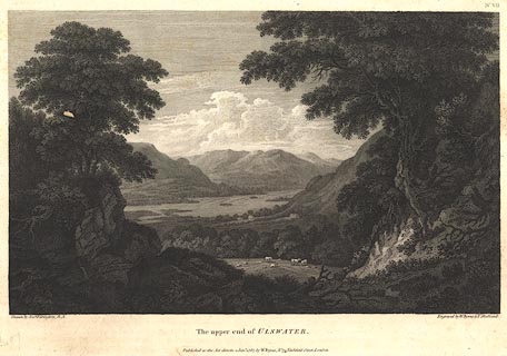
Print, engraving, The Upper End of Ullswater, painted by
Joseph Farington, engraved by W Byrne and T Medland,
published by W Byrne, 79 Titchfield Street, London, 1787.
Looking north from Martindale fell. Plate 7 from Views of the Lakes, &c, in Cumberland and Westmorland, published 1789. Pasted in the Lowther scrapbook, vol.2; between pp.406-407; with descriptive text:- THE UPPER END OF ULLSWATER. / ULLSWATER lies to the east of Derwentwater and to the north of Winandermere. It is size one of the most considerable of the lakes, being in length about eight miles, though it's greatest breadth does not exceed one. It's direction like that of all the others is north and south. In point of beauty is by many thought not inferior to any of them: In one respect it certainly has the superiority, viz. in affording the greatest variety. This advantage it derives from it's shape, which nearly resembles that of the letter Z, but without it's angular sharpness. It is of course separated into three distinct reaches, winding at every turn round some bold projection of the surrounding mountains. This plate presents a prospect of the upper division looking down the lake, as viewed from the skirts of Martindale-fell. The rivulet which serpentizes through the meadows is called Goldrill-beck, and is one of the principal feeders of the lake; it descends from Kirkston-fell, which forms the barrier between Winandermere and Ullswater. This is the only division of the lake, which is adorned with islands. / No.VII. |
||
| source type:- | Farington 1789 (plate 7) | |
| inscription:- |
printed bottom left, right, centre
Drawn by Josh. Farington, R.A. / Engraved by W. Byrne & T. Medland. / The upper end of ULLSWATER. / Published as the Act directs, 1 Jany. 1787, by W. Byrne, No.79 Titchfield Street, London. |
|
| wxh:- | 34.5x24cm | |
|
from:- Scrapbook, 4 volumes, History of Westmorland and Cumberland Illustrated, of descriptive texts, maps, and prints of views and coats of arms, for Westmorland and Cumberland, assembled by a member of the Lowther Family, late 18th early 19th century. The volumes are quarter bound, with marbled paper on the covers; each has a bookplate inside the front cover. The pages cut from various sources are nicely mounted, two sided pieces set neatly in a window in the scrapbook page. The main content is the whole of the two volumes of The History and Antiquities of the Counties of Westmorland and Cumberland, by Joseph Nicolson and Richard Burn, published London, 1777. Nicolson and Burn volume 1 is in scrapbook volumes 1 and 2, volume 2 in scrapbook volumes 3 and 4. Maps and prints are interspersed to make an illustrated version of the history. Some of the sources of maps and prints have been recognised:- Maps - coast of Cumberland etc by Andrew Dury, 1764; Westmorland and Cumberland by Richard Blome, 1673; sheets from Britannia Depicta, Emanuel Bowen, 1720; Cumberland by John Speed, Henry Overton edn 1695; Cumberland by John Cary 1787. Prints from the Set of prints, 20 engravings, Views of the Lakes etc in Cumberland and Westmorland, drawn by Joseph Farington, published by William Byrne, London, 1789. Note that plate numbers vary from edition to edition of this set. Prints from the Antiquities of Great Britain, drawings by Thomas Hearne, engraved by William Byrne, published by Hearne and Byrne, London, 1786-1807. Prints from Britannia Illustrata, drawings by Leonard Knyff, engraved by John Kip, published London, 1707-1740. Print from A Tour in England and Scotland, by Thomas Newte, published by G G J and J Robinson, Paternoster Row, London, 1788.. Some of the coat of arms are cut from A Display of Heraldrie by John Guillim late Pursuivant at Armes, published London, about 1610-11 to 1755. Coats of arms probably from The Baronetage of England, by Edward Kimber and Richard Johnson, published London? 1771. Pages from The Antiquarian Repertory, by Francis Grose, Thomas Astle, et al, published London, 1775-1809. Text from the Baronetage of England by Collins? Scraps cut from an unidentified gazetteer. At the end is the title page and pp.7-51 from A General View of the Agriculture of the County of Cumberland, by John Bailey and George Culley, published by C Macrae, London, 1794. Individual maps and prints are documented separately; with a note of their position in the scrapbooks. inscription:- : embossed: label on spine: (tatty remains): HI[ ] / [ ]/WEST[ ]M[ ] / [ ] / CUM[ ]M[ ] / ILLUS[ ]T[E ] inscription:- : printed & embossed: bookplate: gold on grey; crest, 6 annulets from the coat of arms, flowers, thistles: LOWTHER |
||