 Rydal Mere

|

|
|
|
item:- Dove Cottage : Lowther.5 image:- © see bottom of page |
click to enlarge |
|
|
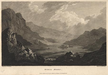
Print, engraving, Rydal Mere ie Rydal Water, Lakes,
Westmorland, painted by Joseph Farington, engraved by B T
Pouncy, published by W Byrne, 79 Titchfield Street, London,
1785.
Plate 6 from Views of the Lakes, &c, in Cumberland and Westmorland, published 1789. Pasted in the Lowther scrapbook, vol.1; between pp.150-151; with descriptive text:- RYDAL-MERE / IS the least in Extent of any of the Lakes in this Set. It is about two Miles from Ambleside, and is formed by the Stream of Rothay, in its Course from Grasmere to Winandermere. The View given in this Plate has the Appearance of an Amphitheatre. The wild and desert Air of the Mountains, which rise immediately from its Margin, exhibits a striking Contrast to the Luxuriance and Cultivation of the Vale of Grasmere. This Variety of Character assumed by the several Lakes affords no small Source of Entertainment to the Admirer of picturesque Beauty. The Richness of the Cultivated Vale and the savage Aspect of the Rocks, with the infinite Variety of Combinations they admit of, present him with the beautiful and sublime through all their possible Gradations.He will remark too with Pleasure, that this Country, so far from having suffered by the Hand of Art, derives considerable Advantage from accidental Circumstances. That the white or Grey-Stone Cottages, with Ash-coloured Slating, are scattered over the Face of the Country, enlivening the Landscape, without affecting its Simplicity; and that even the dark Hue of the Fir-Tree, which is frequently planted near them, is beautifully contrasted with the Brilliancy of the Silver Rock. In passing the River, or Mountain Torrent, he will find the same Propriety preserved in the rude and varied Construction of their Bridges; as if the Genius of the Country, jealous of the officious Interference of Man, had directed the Taste of the Inhabitants. |
||
| source type:- | Farington 1789 (plate 6) | |
| inscription:- |
printed bottom, left, right, centre
Drawn by Josh. Farington / Engraved by B. T. Pouncy / RYDAL MERE / London : Published as the Act directs, 1 March 1785, by W. Byrne, No,79 Titchfield Street. |
|
| wxh, sheet:- | 49x30.5cm | |
| wxh, plate:- | 365x254mm | |
| wxh, print:- | 343x213mm | |
|
from:- Scrapbook, 4 volumes, History of Westmorland and Cumberland Illustrated, of descriptive texts, maps, and prints of views and coats of arms, for Westmorland and Cumberland, assembled by a member of the Lowther Family, late 18th early 19th century. The volumes are quarter bound, with marbled paper on the covers; each has a bookplate inside the front cover. The pages cut from various sources are nicely mounted, two sided pieces set neatly in a window in the scrapbook page. The main content is the whole of the two volumes of The History and Antiquities of the Counties of Westmorland and Cumberland, by Joseph Nicolson and Richard Burn, published London, 1777. Nicolson and Burn volume 1 is in scrapbook volumes 1 and 2, volume 2 in scrapbook volumes 3 and 4. Maps and prints are interspersed to make an illustrated version of the history. Some of the sources of maps and prints have been recognised:- Maps - coast of Cumberland etc by Andrew Dury, 1764; Westmorland and Cumberland by Richard Blome, 1673; sheets from Britannia Depicta, Emanuel Bowen, 1720; Cumberland by John Speed, Henry Overton edn 1695; Cumberland by John Cary 1787. Prints from the Set of prints, 20 engravings, Views of the Lakes etc in Cumberland and Westmorland, drawn by Joseph Farington, published by William Byrne, London, 1789. Note that plate numbers vary from edition to edition of this set. Prints from the Antiquities of Great Britain, drawings by Thomas Hearne, engraved by William Byrne, published by Hearne and Byrne, London, 1786-1807. Prints from Britannia Illustrata, drawings by Leonard Knyff, engraved by John Kip, published London, 1707-1740. Print from A Tour in England and Scotland, by Thomas Newte, published by G G J and J Robinson, Paternoster Row, London, 1788.. Some of the coat of arms are cut from A Display of Heraldrie by John Guillim late Pursuivant at Armes, published London, about 1610-11 to 1755. Coats of arms probably from The Baronetage of England, by Edward Kimber and Richard Johnson, published London? 1771. Pages from The Antiquarian Repertory, by Francis Grose, Thomas Astle, et al, published London, 1775-1809. Text from the Baronetage of England by Collins? Scraps cut from an unidentified gazetteer. At the end is the title page and pp.7-51 from A General View of the Agriculture of the County of Cumberland, by John Bailey and George Culley, published by C Macrae, London, 1794. Individual maps and prints are documented separately; with a note of their position in the scrapbooks. inscription:- : embossed: label on spine: (tatty remains): HI[ ] / [ ]/WEST[ ]M[ ] / [ ] / CUM[ ]M[ ] / ILLUS[ ]T[E ] inscription:- : printed & embossed: bookplate: gold on grey; crest, 6 annulets from the coat of arms, flowers, thistles: LOWTHER |
||