 Lowdore Waterfall

|

|
|
|
item:- Dove Cottage : Lowther.59 image:- © see bottom of page |
click to enlarge |
|
|
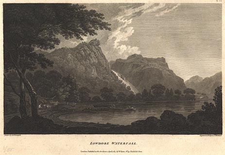
Print, engraving, Lowdore Waterfall, painted by Joseph
Farington, engraved by W Byrne and T Medland, published by W
Byrne, 79 Titchfield Street, London, 1785.
Plate 4 from Views of the Lakes, &c, in Cumberland and Westmorland, published 1789. Lodore fall in spate, between Gowder Crag and Brund Fell? Pasted in the Lowther scrapbook, vol.3; between pp.90-91; with descriptive text:- LOWDORE WATERFALL / IS generally esteemed one of the most striking Objects of the Kind in this country; its Accompanyments are uncommonly picturesque and grand. These indeed compose of themselves a Scene which cannot but interest the Spectator, even when the Fall of the Water, which depends upon the State of the Weather, is inconsiderable. The stupendous Craggs between which the Torrent precipitates itself broken into the boldest Forms, are shagged with Trees hanging every where in the most fantastic Shapes, from the Fissures of the Rock. The Height of the Fall itself Mr. Gray conjectures to be about two Hundred Feet. At some Distance above the Fall the Stream proceeds from a Lake about a Mile in Circumference. To this sequestered Spot Travellers are seldom conducted, though they might perhaps think themselves amply recompensed for their Trouble, by a Sight of the various romantic Circumstances which occur in this Excursion: The Lake and Village near it are called Wawtenleth. The Point from whence this View is taken is a little to the Right of the Road leading from Keswick into Borrowdale, near the Side of the Derwentwater, where it forms a small Bay. As these Engravings are offered to the Public as faithful Representations of Nature, it may not be improper to observe that the Permanency of the Resemblance is liable to be affected by the frequent Fall of Timber and Coppice Wood which takes place on the Borders of these Lakes. An Allowance will of course be made for any Variation of this Kind which may appear between the Plate and the Original. / IV. |
||
| source type:- | Farington 1789 (plate 4) | |
| inscription:- |
printed bottom left, right, centre
Drawn by Josh. Farington / Engraved by W. Byrne & T. Medland / LOWDORE WATERFALL. / London : Published as the Act directs, 1 April 1785, by W. Byrne, No,79, Titchfield Street. |
|
| wxh:- | 35x24cm | |
|
from:- Scrapbook, 4 volumes, History of Westmorland and Cumberland Illustrated, of descriptive texts, maps, and prints of views and coats of arms, for Westmorland and Cumberland, assembled by a member of the Lowther Family, late 18th early 19th century. The volumes are quarter bound, with marbled paper on the covers; each has a bookplate inside the front cover. The pages cut from various sources are nicely mounted, two sided pieces set neatly in a window in the scrapbook page. The main content is the whole of the two volumes of The History and Antiquities of the Counties of Westmorland and Cumberland, by Joseph Nicolson and Richard Burn, published London, 1777. Nicolson and Burn volume 1 is in scrapbook volumes 1 and 2, volume 2 in scrapbook volumes 3 and 4. Maps and prints are interspersed to make an illustrated version of the history. Some of the sources of maps and prints have been recognised:- Maps - coast of Cumberland etc by Andrew Dury, 1764; Westmorland and Cumberland by Richard Blome, 1673; sheets from Britannia Depicta, Emanuel Bowen, 1720; Cumberland by John Speed, Henry Overton edn 1695; Cumberland by John Cary 1787. Prints from the Set of prints, 20 engravings, Views of the Lakes etc in Cumberland and Westmorland, drawn by Joseph Farington, published by William Byrne, London, 1789. Note that plate numbers vary from edition to edition of this set. Prints from the Antiquities of Great Britain, drawings by Thomas Hearne, engraved by William Byrne, published by Hearne and Byrne, London, 1786-1807. Prints from Britannia Illustrata, drawings by Leonard Knyff, engraved by John Kip, published London, 1707-1740. Print from A Tour in England and Scotland, by Thomas Newte, published by G G J and J Robinson, Paternoster Row, London, 1788.. Some of the coat of arms are cut from A Display of Heraldrie by John Guillim late Pursuivant at Armes, published London, about 1610-11 to 1755. Coats of arms probably from The Baronetage of England, by Edward Kimber and Richard Johnson, published London? 1771. Pages from The Antiquarian Repertory, by Francis Grose, Thomas Astle, et al, published London, 1775-1809. Text from the Baronetage of England by Collins? Scraps cut from an unidentified gazetteer. At the end is the title page and pp.7-51 from A General View of the Agriculture of the County of Cumberland, by John Bailey and George Culley, published by C Macrae, London, 1794. Individual maps and prints are documented separately; with a note of their position in the scrapbooks. inscription:- : embossed: label on spine: (tatty remains): HI[ ] / [ ]/WEST[ ]M[ ] / [ ] / CUM[ ]M[ ] / ILLUS[ ]T[E ] inscription:- : printed & embossed: bookplate: gold on grey; crest, 6 annulets from the coat of arms, flowers, thistles: LOWTHER |
||