 View of Skiddaw and Derwentwater

|

|
|
|
item:- Dove Cottage : Lowther.53 image:- © see bottom of page |
click to enlarge |
|
|
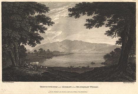
Print, engraving, View of Skiddaw and Derwentwater,
painted by Joseph Farington, engraved by B T Pouncy,
published by W Byrne, 79 Titchfield Street, London, 1785.
Taken from the lake margin in Brandlehow Park. Plate 3 from Views of the Lakes, &c, in Cumberland and Westmorland, published 1789. Pasted in the Lowther scrapbook, vol.3; between pp.86-87; with descriptive text:- A VIEW of SKIDDAW and DERWENTWATER. / THIS Plate exhibits a View of the Mountain of Skiddaw, and the Lake of Derwentwater, as seen from Brandelow-Woods on its Western Shore. The Town of Keswick appears on its opposite Side, a little to the Right. Skiddaw may be ranked amongst the highest Hills in the Island: Its greatest Elevation is 3270 Feet above the Level of the Sea, and not much less above that of the Lake. The Surface of this Mountain is smooth and verdant. It may not be improper here to observe, that the Hills among which these Lakes are situated, assume a very different Character, according to the Nature of the Rock they are composed of; this is either blue Rag, or Limestone. Where the former prevails the Mountain has a forbidding and somewhat savage Aspect; its Surface is deformed with swampy Patches, or Pits of Turbary, and the Pasturage for the most Part is mossy, heathy, and wet. Those temporary Cataracts, which in rainy Weather perpetually attract the Notice of the Stranger, are peculiar to this Species of Mountain. Those which consist of Limestone, though generally of inferior Height, present an Appearance more chearful and agreeable to the Eye. They are perfectly dry, and where they are covered with Soil, the Bent or Grass is of the finest Sort. The Lake of Derwentwater is about three Miles in Length, from North to South; its Breadth about a Mile and a Half. It derives much Beauty from the Islands which are interspersed in it; the principal of these is Lord's Island. about five Acres in Extent, where the unfortunate family of RATCLIFF had once its Residence, taking the Title of Derwentwater from the Lake itself. The Breadth of this Lake bearing so considerable a Proportion to its Length, it nearly retains its Form from whatever Point it is viewed, never assuming the Appearance of a river, which is a Distinction peculiar to itself. / III. |
||
| source type:- | Farington 1789 (plate 3) | |
| inscription:- |
printed bottom, left, right, centre
Drawn by Josh. Farington / Engraved by B. T. Pouncy. / DERWENTWATER and SKIDDAW, from BRANDELOW WOODS. / London : Published as the Act directs, 15 April 1785, by W. Byrne, No.79 Titchfield Street. |
|
| wxh:- | 35x24cm | |
|
from:- Scrapbook, 4 volumes, History of Westmorland and Cumberland Illustrated, of descriptive texts, maps, and prints of views and coats of arms, for Westmorland and Cumberland, assembled by a member of the Lowther Family, late 18th early 19th century. The volumes are quarter bound, with marbled paper on the covers; each has a bookplate inside the front cover. The pages cut from various sources are nicely mounted, two sided pieces set neatly in a window in the scrapbook page. The main content is the whole of the two volumes of The History and Antiquities of the Counties of Westmorland and Cumberland, by Joseph Nicolson and Richard Burn, published London, 1777. Nicolson and Burn volume 1 is in scrapbook volumes 1 and 2, volume 2 in scrapbook volumes 3 and 4. Maps and prints are interspersed to make an illustrated version of the history. Some of the sources of maps and prints have been recognised:- Maps - coast of Cumberland etc by Andrew Dury, 1764; Westmorland and Cumberland by Richard Blome, 1673; sheets from Britannia Depicta, Emanuel Bowen, 1720; Cumberland by John Speed, Henry Overton edn 1695; Cumberland by John Cary 1787. Prints from the Set of prints, 20 engravings, Views of the Lakes etc in Cumberland and Westmorland, drawn by Joseph Farington, published by William Byrne, London, 1789. Note that plate numbers vary from edition to edition of this set. Prints from the Antiquities of Great Britain, drawings by Thomas Hearne, engraved by William Byrne, published by Hearne and Byrne, London, 1786-1807. Prints from Britannia Illustrata, drawings by Leonard Knyff, engraved by John Kip, published London, 1707-1740. Print from A Tour in England and Scotland, by Thomas Newte, published by G G J and J Robinson, Paternoster Row, London, 1788.. Some of the coat of arms are cut from A Display of Heraldrie by John Guillim late Pursuivant at Armes, published London, about 1610-11 to 1755. Coats of arms probably from The Baronetage of England, by Edward Kimber and Richard Johnson, published London? 1771. Pages from The Antiquarian Repertory, by Francis Grose, Thomas Astle, et al, published London, 1775-1809. Text from the Baronetage of England by Collins? Scraps cut from an unidentified gazetteer. At the end is the title page and pp.7-51 from A General View of the Agriculture of the County of Cumberland, by John Bailey and George Culley, published by C Macrae, London, 1794. Individual maps and prints are documented separately; with a note of their position in the scrapbooks. inscription:- : embossed: label on spine: (tatty remains): HI[ ] / [ ]/WEST[ ]M[ ] / [ ] / CUM[ ]M[ ] / ILLUS[ ]T[E ] inscription:- : printed & embossed: bookplate: gold on grey; crest, 6 annulets from the coat of arms, flowers, thistles: LOWTHER |
||