 General View of Derwentwater

|

|
|
|
item:- Dove Cottage : Lowther.51 image:- © see bottom of page |
click to enlarge |
|
|
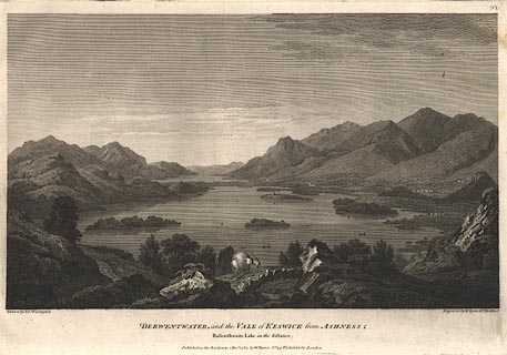
Print, engraving, General View of Derwentwater, painted
by Joseph Farington, engraved by W Byrne and T Medland,
published by W Byrne, 79 Titchfield Street, London, 1784.
A packhorse on Ashness Bridge in the foreground, Derwent Water with many islands. Plate 1 from Views of the Lakes, &c, in Cumberland and Westmorland, published 1789. Pasted in the Lowther scrapbook, vol.3; between pp.82-83; with descriptive text:- GENERAL VIEW OF DERWENTWATER. / THIS View is intended to convey a general Idea of the Valley of Keswick. Ashness, from whence it is taken, is on the Summit of the Rocks which hang over the Road leading to Lowdore, distant from Keswick about two Miles and a Half. No other Point can perhaps be fixed upon where the several Features which distinguish this romantic Vale will appear to be so strongly marked. The Elevation is sufficient to command an extensive Prospect, without so far reducing its component parts as materially to affect their Importance. A great Part of Derwentwater, including its four principal Islands, is in Front, and the Lake of Bassenthwaite in the Distance. The Stream which forms the Communication between them is only to be traced by the Flatness and Luxuriance of the adjacent Meadows. The Foot of Bassenthwaite is distant about ten Miles from Ashness. From the Margin of this Lake on the Right rises Skiddaw, on whose Skirts appear a part of the Town of Keswick; the rest is concealed from the View by Cockshut-Hill. On the Left of Derwentwater are Newlands and Thornthwaite-Fells. Beyond these are the Woods of Wythop hanging over the more distant Lake. The whole View is terminated by Caer-Mote, a Hill remarkable for still retaining the evident Traces of a Roman Encampment. / No.I. |
||
| source type:- | Farington 1789 (plate 1) | |
| inscription:- |
printed bottom, left, right, centre
Drawn by Josh. Farington / Engraved by W. Byrne & T. Medland / DERWENTWATER and the VALE of KESWICK from ASHNESS; / Bassenthwaite Lake in the distance / Published as the Act directs, 1 Decr. 1784, by W. Byrne, No.79 Titchfield Str. London. |
|
| wxh:- | 35x24cm | |
|
from:- Scrapbook, 4 volumes, History of Westmorland and Cumberland Illustrated, of descriptive texts, maps, and prints of views and coats of arms, for Westmorland and Cumberland, assembled by a member of the Lowther Family, late 18th early 19th century. The volumes are quarter bound, with marbled paper on the covers; each has a bookplate inside the front cover. The pages cut from various sources are nicely mounted, two sided pieces set neatly in a window in the scrapbook page. The main content is the whole of the two volumes of The History and Antiquities of the Counties of Westmorland and Cumberland, by Joseph Nicolson and Richard Burn, published London, 1777. Nicolson and Burn volume 1 is in scrapbook volumes 1 and 2, volume 2 in scrapbook volumes 3 and 4. Maps and prints are interspersed to make an illustrated version of the history. Some of the sources of maps and prints have been recognised:- Maps - coast of Cumberland etc by Andrew Dury, 1764; Westmorland and Cumberland by Richard Blome, 1673; sheets from Britannia Depicta, Emanuel Bowen, 1720; Cumberland by John Speed, Henry Overton edn 1695; Cumberland by John Cary 1787. Prints from the Set of prints, 20 engravings, Views of the Lakes etc in Cumberland and Westmorland, drawn by Joseph Farington, published by William Byrne, London, 1789. Note that plate numbers vary from edition to edition of this set. Prints from the Antiquities of Great Britain, drawings by Thomas Hearne, engraved by William Byrne, published by Hearne and Byrne, London, 1786-1807. Prints from Britannia Illustrata, drawings by Leonard Knyff, engraved by John Kip, published London, 1707-1740. Print from A Tour in England and Scotland, by Thomas Newte, published by G G J and J Robinson, Paternoster Row, London, 1788.. Some of the coat of arms are cut from A Display of Heraldrie by John Guillim late Pursuivant at Armes, published London, about 1610-11 to 1755. Coats of arms probably from The Baronetage of England, by Edward Kimber and Richard Johnson, published London? 1771. Pages from The Antiquarian Repertory, by Francis Grose, Thomas Astle, et al, published London, 1775-1809. Text from the Baronetage of England by Collins? Scraps cut from an unidentified gazetteer. At the end is the title page and pp.7-51 from A General View of the Agriculture of the County of Cumberland, by John Bailey and George Culley, published by C Macrae, London, 1794. Individual maps and prints are documented separately; with a note of their position in the scrapbooks. inscription:- : embossed: label on spine: (tatty remains): HI[ ] / [ ]/WEST[ ]M[ ] / [ ] / CUM[ ]M[ ] / ILLUS[ ]T[E ] inscription:- : printed & embossed: bookplate: gold on grey; crest, 6 annulets from the coat of arms, flowers, thistles: LOWTHER |
||