 Morden 1695

|

|
|
|
item:- JandMN (90) image:- © see bottom of page |
click to enlarge |
|

|
menu with map squares and placename index | |
|
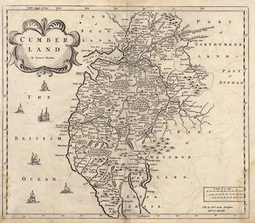
Map, uncoloured engraving, Cumberland, scale about 4
miles to 1 inch, by Robert Morden, 1695, published by Abel
Swale, the Unicorn, St Paul's Churchyard, Awnsham, and John
Churchill, the Black Swan, Paternoster Row, London,
1695-1715.
Included in Camden's Britannia, Newly Translated into English, by Edmund Gibson, Queens College, Oxford. |
||
|
|
Morden 1695 | |
| map feature:- | scroll cartouche (?) & up is N & scale lines & lat and long scales & sea plain & coast shaded & rivers & bridges & lakes & relief & hillocks & woods & forests & parks & county & wards (hundreds) & settlements | |
| inscription:- |
printed title cartouche, upper left
CUMBER / LAND / By Robert Morden |
|
| inscription:- |
printed lower right
Sold by Abel Swale Awnsham / and Iohn Churchill |
|
| scale line:- | 10 miles = 56.4 mm | |
| scale line:- | 10 miles = 59.5 mm | |
| scale line:- | 10 miles = 63.9 mm | |
| scale:- | 1 to 270000 ? (1 to 269225 averaged from scale lines wrongly assuming a statute mile) | |
| wxh, sheet:- | 44.5x40cm | |
| wxh, plate:- | 428x366mm | |
| wxh, map:- | 424x363mm | |