 Saxton 1579

|

|
|
|
item:- private collection (15) image:- © see bottom of page |
click to enlarge |
|
|
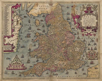
Map, hand coloured engraving, Anglia ie England and
Wales, scale about 22 miles to 1 inch, by Christopher
Saxton, engraved by Augustine Ryther, published in an atlas
of counties, London, 1579.
|
||

|
Saxton 1579 | |
| map feature:- | strapwork cartouche & coat of arms & compass rose & labelled borders & up is N & scale line & lat and long scales & sea stippled & galleons & sea monsters & coast shaded & rivers & relief & hillocks & forests & county & settlements & | |
| scale line:- | 50 miles = 57.7 mm | |
| wxh, map:- | 234x488mm | |
| scale:- | 1 to 1400000 ? (1 to 1394579 from scale line wrongly assuming a statute mile) | |
|
||