 Garnett 1850s-60s H

|

|
|

|
back to object record | |
| Map Features | ||
|
|
||
|
title
map maker publisher |
Printed: lower left:-
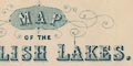
MAP OF THE ENGLISH LAKES. Printed at the bottom:- PUBLISHED BY JOHN GARNETT WINDERMERE The guide book in which the map was found was published by Adam and Charles Black, Edinburgh, 1852: from the evidence of railways on the map it was published about 1876. It does not belong to this guide book. In the guide book an advertisement on the front end papers, states:- With a minutely accurate Map, by W Hughes ... which is not this map. |
|
|
|
||
| table of symbols |
Printed lower left is a table of symbols mostly for
transport:-
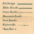
Railways [triple line, light bold light] Main Roads [double line, light bold] Cross Roads [double line, light light] Mountains Roads [double line, dotted] Foot Roads [single line, dotted] Waterfalls [double line across a stream] Churches [cross (+)] |
|
|
|
||
|
orientation
north point up is N |
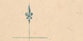
Printed lower left is a north point; N-S line, E-S line, North marked by a spear point. The map is printed with North at the top of the sheet. |
|
|
|
||
|
scale line
scale |
Printed lower left is a:-
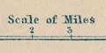
Scale of Miles marked and labelled in miles. The 5 miles = 36.9 mm gives a scale 1 to 218068. The map scale is about 1 to 220000 3.5 miles to 1 inch |
|
|
|
||
| lat and long scales |
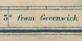
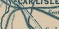
Printed in the map borders are scale of latitude and longitude for a ?trapezoidal projection; marked in minutes, labelled at 10s. The bottom longitude scale is labelled:- Longitude West from Greenwich Judging from the scales the longitude, Kendal = 2d 47m W which is slightly wrong for a Greenwich prime meridian. The map includes from 2d 30m to 3d 38m W, from 54d 2m to 54d 56m N; Cumberland is cut off north of Carlisle, Westmorland cut off east of Appleby, all of Lancashire north of the sands is included. |
|
|
|
||
|
sea area
sea plain |
The sea is plain. Some sea areas are labelled, eg:-
IRISH SEA MORECAMBE BAY |
|
|
|
||
|
coast line
coast form lines headlands harbours foreshore |
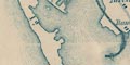
The coast line is emphasized by form lines which are engraved attractively into the river estuaries and around Walney Island. A couple of headlands are noticed:- Grune Pt. St. Bees Head. Harbours are not noticed, but see:- Piel Pier and the docks at Barrow are clearly marked. Foreshore sands are not marked, but two of the great estuaries have labels:- Duddon sands Leven Sands |
|
|
|
||
|
rivers
bridges |
Rivers are drawn by wiggly line tapering upstream. Some
rivers are drawn by a double line, perhaps with a stream
line. Some rivers are labelled, eg:-
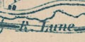
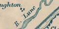
R. Lune Leven R. R. Kent Croglin W. [ie Water] Crummock Beck which last is drawn flowing from the sea near Allonby to join the Waver at Abbeyholme, and thence to the sea! Waterfalls might be marked by two lines across a stream. For example see on the Trout Beck SW of Ill Bell, labelled:- Force and see, eg:- 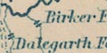
Birker Force Dalegarth Force Bridges are implied where a road crosses and interrupts a stream. 
A label as:- Newby Bridge might label the bridge or the settlement at the bridge. |
|
|
|
||
| lakes |
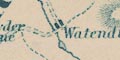
Lakes are drawn in outline with form lines. Some lakes are labelled:- Angle T. [Sca Fell] Angle Tarn [Patterdale] BASSENTHWAITE WR. Beacon Tarn Blea T. [Langdale] Blea Tarn [Borrowdale] Blea Wr. Bleaberry T. Blelham Tarn Bowscale Tarn Brothers Water Burnmoor Tarn BUTTER MERE Codale T. CONISTON WATER CRUMMOCK WR. DERWENT WR. Devoke Water Easdale T. Elter Water ENNERDALE WR. ESTHWAITE WATER Floutern Tarn Goat Wr. GRASMERE LAKE Harrop T. HAWES WR. Hayes Wr. Keppel Cove Tarn Langdale Tarn Levers Wr. Lily Tarn LOWES WATER Over Water Red Tarn [Helvellyn] RYDAL WR. Scales Tarn Seathwaite T. Skeggles Wr. Sprinkling Tarn Stickle Tarn Styhead T. THIRL MERE ULLES WATER WAST WATER WINDER MERE Other lakes and tarns might be recognized, eg:- Cardurnock Lough Eskrigg Tarn Grisedale Tarn lake, Aspatria lake, Fusedale? lake, Monkcastle? lake, Old Ponsonby? Little Tarn Loughrigg Tarn Low Birker Tarn Low Tarn Mockerkin Tarn Monkhill Lough? Out Dubs Tarn Red Moss Scoat Tarn Small Water Tarnhouse Tarn Thursfield Lough Urswick Tarn Watendlath Tarn Some of these cannot be found on recent maps. |
|
|
|
||
|
relief
hill hachuring |
Some relief is indicated by hill hachuring; some hills
and ridges in the central Lakes area, and the Pennines. Some
hills are labelled, eg:-
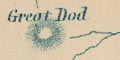
Great Dod Brocklebank Fell Skiddaw Stickle Pikes Some valleys might be labelled, but are hardly marked by the hachuring, eg:- Eskdale Patterdale A few passes are labelled, eg:- 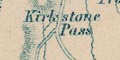
Kirkstone Pass Gatescarth Pass |
|
|
|
||
| forests |
Woodland is not indicated, but some forests are labelled,
eg:-
Inglewood Forest Copeland Forest |
|
|
|
||
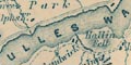
| parks |
Parks are not marked, but some are labelled, eg:-
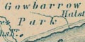
Gowbarrow Park |
|
|
|
||
| county |
The county boundaries are a dot dash line which might be continued alongside a boundary feature, perhaps as a fine dotted line. It is not clear how county boundaries fit round or through Windermere lake, or Ullswater. The county areas are labelled:- WESTMORELAND CUMBERLAND LANCASHIRE Remember: this is not a county map, but a map of The Lakes. |
|
|
|
||
| settlements |
Settlements are marked b blocks, perhaps a cross,
differentiated by style of labelling - which is confusing
and not explained.
|
|
| cities |
blocks, with a suggestion of a street plan; labelled in
upright, sans serif block caps:-
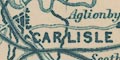
CARLISLE |
|
| towns |
blocks; labelled in upright, sans serif block caps,
eg:-
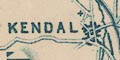
KENDAL PENRITH AMBLESIDE And sometimes labelled in upright, seriffed block caps, eg:- 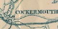
COCKERMOUTH APPLEBY Or labelled in smaller upright, sans serif block caps, eg:- CONISTON WINDERMERE Or labelled in upright, seriffed lowercase text, eg:- 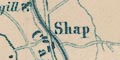
Shap Hesket Newmarket |
|
|
villages
hamlets |
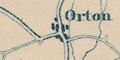
blocks, perhaps a cross; labelled in italic lowercase
text, eg:-
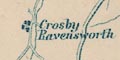
Crosby Ravensworth Gosforth Garnett Bridge Brathwaite |
|
|
|
||
|
roads
sands roads |
A network of roads is drawn by double and single lines, solid and dotted, explained in the table of symbols. Dotted does means not unfenced, but wilder roads. Main roads, cross roads, mountain roads, and foot roads are distinguished. Notice that main roads use the convention of a double line with light and bold lines. 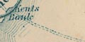
Routes across the sands are drawn by a double dotted line (a mountain road according to the table of symbols). Across Leven sands from the coast near Cark in Cartmel to the foot of the Ulverston Canal. And across Lancaster Sands from Hest Bank, northerly then westerly, to Kent's Bank, labelled:- Road across the Sands at Low Water |
|
|
|
||
| canals |
Canals, not included in the table of symbols, are marked by a bold line. The Ulverston Canal and Lancaster Canal are shown. The Port Carlisle canal has gone. |
|
|
|
||
| railways |
Railways are drawn by a triple line, light bold light. Some railways are labelled. Stations out of major settlements are marked by a dot beside the line, and labelled, eg:- Station Arkleby Station The following railways are shown:- |
|
| Solway Junction Railway |
1869-70
|
|
| Port Carlisle Dock and Railway |
1854
|
|
| Carlisle and Silloth Bay Railway |
1857
|
|
| Maryport and Carlisle Railway |
1840-45
labelled:- Whitehaven, Maryport & Carlisle Railway |
|
| Caledonian Railway |
1847
labelled:- Caledonian Raily. |
|
| Whitehaven Junction Railway |
1846-47
|
|
| Cockermouth and Workington Railway |
1847
|
|
| Newcastle and Carlisle Railway |
1836
labelled:- Newcastle & Carlisle Raily. |
|
| Settle and Carlisle Railway |
1876
labelled:- Midland Railway |
|
| Cockermouth, Keswick and Penrith Railway |
1864-65
|
|
| Whitehaven, Cleator and Egremont Railway |
1856-57
|
|
| Egremont and Sellafield branch railway |
1869
|
|
| Whitehaven and Furness Junction Railway |
1849-55
labelled:- Whitehaven & Furness Junction Raily. |
|
| Coniston Railway |
1859-60
|
|
| Lancaster and Carlisle Railway |
1846
labelled:- Lancaster & Carlisle Railway |
|
| Eden Valley Railway |
1862
|
|
| South Durham and Lancashire Union Railway |
1861
|
|
| Kendal and Windermere Railway |
1846
labelled:- Kendal & Windermere Railway |
|
| Low Gill and Ingleton branch railway |
1859 (?)
|
|
| Furness Railway |
1846-54
labelled:- Furness Railway |
|
| Lakeside branch railway |
1869
|
|
| Ulverstone and Lancaster Railway |
1857
labelled:- Midland Railway |
|
|
The latest railway shown was opened 1876; the earliest
railway missed was opened 1876. Although the date of a
project and its submission to Parliament is before the date
of opening, the railways shown are for a map that was
produced well after 1852, the date when the guide book
containing the map was published. Now, that's interesting!
All I can suggest is that a crafty book seller has added a
later map to an earlier book to make a good item for
sale.
Looking at the engraving it is likely that some of the railways are added to an earlier edition of the map. The railway line cuts through placename labels, or is interrupted to let existing labels show. |
||
|
|
||
| miscellaneous | ||
|
|
||
| stones |
labelled at the meet of three counties is:-
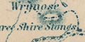
Three Shire Stones |
|
|
|
||
|
mines
lead mines |
In Glenridding is:-
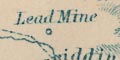
Lead Mine marked by a circle. |
|
|
|
||
|
mines
black lead mines |
At Seathwaite is a circle labelled:-
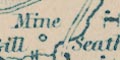
Mine |
|
|
|
||
| inns |
Some inns are noticed, eg:-
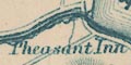
Pheasant Inn [Bassenthwaite lake] Swan Inn [Grasmere] Ferry Inn [Windermere lake] Inn [Patterdale] |
|
|
|
||
| schools |
In Windermere is:-
St. Mary's Coll. |
|
|
|
||
|
antiquities
stone circles |
To the east of Keswick is:-
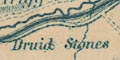
Druid Stones and more on Burnmoor. |
|
Lakes Guides menu.