 Ford 1839 map

|

|
|

|
back to object record | |
| MAP FEATURES | ||
|
|
||
| title |
Printed lower left:-
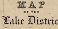
A MAP OF THE Lake District OF CUMBERLAND, WESTMORELAND and LANCASHIRE. In a nice selection of plain and fancy fonts. |
|
|
|
||
|
orientation
compass rose up is N |
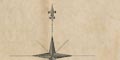
Printed upper left is a compass rose; no circle, star points for cardinal directions, lines for half cardinal, North marked by a fleur de lys. The map is printed with North at the top of the sheet. |
|
|
|
||
|
scale line
scale |
Printed lower left is a scale of:-
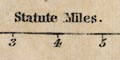
Statute Miles. marked and labelled at one miles intervals, the first miles marked in quarters. The 8 miles = 56.5 mm gives a scale 1 to 227872. The map scale is about:- 1 to 230000 3.5 miles to 1 inch. |
|
|
|
||
| lat and long scales |
Printed in the map borders are scales of latitude and longitude for a trapezoidal projection; chequered and labelled at 5 minute intervals of longitude, but 2 1/2 minute intervals of latitude. The map includes from 2d 15m to 3d 40m W, from 54 3m to 55d 9m N; nearly all Westmorland, Cumberland, and Lancashire north of the sands, plus parts of adjoining counties. |
|
|
|
||
|
sea area
sea plain |
The sea area is plain. Some sea areas are labelled,
eg:-
IRISH SEA SOLWAY FIRTH Wampool Bay Duddon Mouth |
|
|
|
||
|
coast line
headlands lighthouses harbours |
The coast line is bold but not emphasized except by its wiggliness, which catches the eye. Some headlands are labelled, eg:- Grune Pt. St. Bees Head A lighthouse is marked by a tower symbol on St Bees Head, labelled:- 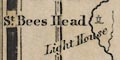
Light House A harbour is noticed at:- Harrington Harb. |
|
|
|
||
|
rivers
bridges ferries |
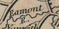
River are drawn by a wiggly line tapering upstream. Some rivers are labelled, eg:- Caldew R. Kent River King Water R. Tyne A waterfall might be marked by lines across the stream, as at:- 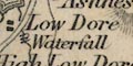
[Low Dore] Waterfall or otherwise just labelled, eg:- Scale Force though this be taken to be the label for the stream. Bridges are implied where a road crosses and interrupts a stream. Some bridges are labelled, eg:- 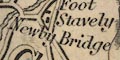
Newby Bridge Lobby Br. [on the Winster] The ferry across Windermere is not marked. But the roads are drawn to suggest the ferry, and on the Claife shore is:- 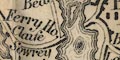
Ferry Ho. |
|
|
|
||
| lakes |
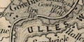
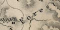
Lakes are drawn in outline with form lines. Some lakes are labelled:- Bassenthwaite W. Brothers Water Burnmoor Tarn Buttermere Wr. Coniston Water Crummock Water Derwent Water Devock Water Eastwaite Water Elter Water Ennerdale Wr. Grasmere Lake Hawes W. Kent Mere Tarn Lowes W. Over Water Rydal L. Sparkling Tarn Sunbiggin Tarn Talkin Tarn Tarn Wadling Thirle Water Tindal Tarn ULLES WATER Wast Water WINDER MERE Other lakes might be recognized, eg:- Whinfell Tarn (?) |
|
|
|
||
|
relief
hill hachuring |
Relief is indicated by hill hachuring. Although some hachures are bolder than others, for larger mountains, you do not, for example, get any sense of the importance of Sca Fell; Black Combe is more prominent. Some hills are labelled, eg:- Pillar Screes [by Wast Water] SHAP FELLS Rydal Head Red Pike Some valleys, lying between hills, are labelled, eg:- Sleddale [Wet Sleddale] |
|
|
|
||
| forests |
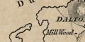
Although woodland is not indicated, some forests are
labelled, eg:-
Copeland Forest |
|
|
|
||
| parks |
Parks are drawn by an outline with fence palings, the
interior pecked. The park might be labelled by name, or the
name of a great house, eg:-
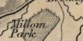
Millom Park Brayton Hall Gowbarrow P. |
|
|
|
||
| county |
County boundaries are a fine dotted line, not continued where another features serves in its place. The county areas are labelled, eg:- WESTMORELAND CUMBERLAND This is not a 'county map': it topographic detail over its whole area. |
|
|
|
||
| settlements |
Settlements are marked by blocks, differentiated by style
of labelling.
|
|
| cities |
group of blocks; labelled in upright block caps:-
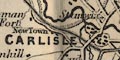
CARLISLE |
|
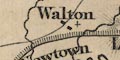
| towns |
group of blocks; labelled in italic block caps, eg:-
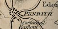
PENRITH KIRKBY LONSDALE Except the de jure county town:- APPLEBY and de facto county town:- KENDAL which are given in upright block caps. |
|
| villages |
block or blocks, sometimes a cross for a church; labelled
in upright lowercase text, eg:-
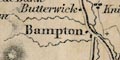
Bampton Askham |
|
| hamlets |
block or blocks; labelled in italic lowercase text,
eg:-
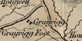
Grayrigg Crook This lettering is the default style for other features. |
|
| castles |
A castle might be marked by a tower symbol, eg:-
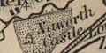
Naworth castle in its park. But at least on castle is marked by an H shape block, at:- Castle [by Millom] As this symbol is also used for Calder Abbey it should not be interpreted as a building with two towers. |
|
|
|
||
|
roads
road distances toll gates sands roads |
A network of roads is drawn by double and single lines. The most important roads are broader double lines, light bold. But the network has to be understood from the perspective of the early 19th century, and bearing in mind the interest of the author of the guide book. Notice the road up Long Sleddale, drawn as a most important route. Lesser roads are narrower double lines, and even lesser, just single lines. Some of the important roads are marked with road distances from town to town. For example the Lancaster to Carlisle road has:- 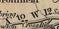
L to B 11 MS. / B to K 11 MS. / K to S 16 MS. / S to P 11 MS. / P to C 18 MS. through Burton in Kendal, Kendal, Shap, and Penrith. Not all the important routes are marked. Those that are labelled are sketched below:- 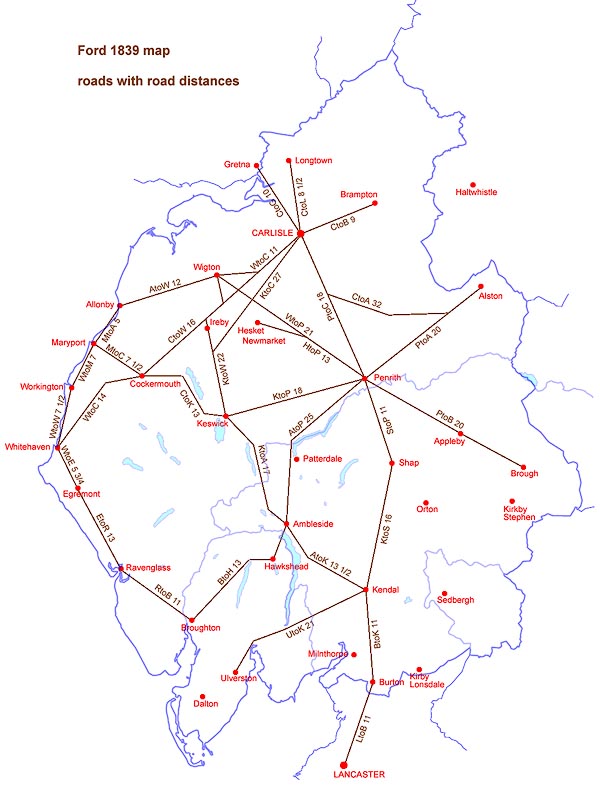
On the road between Appleby and Brough is a label:- Turnpike which might be a toll gate. A dotted line from Hest Bank is drawn to show the sands road across the Lancaster Sands to Kent's Bank. North of the landing place is:- Guide's House The route from Lancaster to Ulverston continues from Holker across the Leven Sands to the- 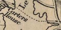
Carters House near Ulverston. A sands road is marked across the Duddon Estuary, and, by a double line, across the estuaries at Ravenglass. |
|
|
|
||
| canals |
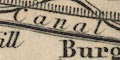
Canals are drawn by a triple line, light bold light. The canals shown are:- |
|
| Carlisle Canal |
from Port Carlisle to Carlisle, Cumberland.
Labelled:-
Canal |
|
| Ulverston Canal |
From Ulverston to the coast of the Leven Estuary,
Cumberland.
|
|
| Lancaster Canal |
from Lancaster, Lancashire to Kendal, Westmorland; but
the route might be inaccurate, the tunnel wiggle is not
shown.
|
|
|
|
||
| railways |
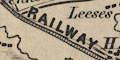
Railways are drawn by a double line with cross ties, sometimes engraved over features on an earlier edition of the map. The railways shown are:- |
|
|
Newcastle and Carlisle Railway
Newcastle and North Shields Railway |
from Carlisle, Cumberland to beyond Haltwhistle,
Northumberland, extended to Newcastle upon Tyne by a n
extension piece pasted to the map sheet. Labelled:-
NEWCASTLE AND CARLISLE RAILWAY NEWCASTLE & NORTH SHIELDS RAILWAY Printed lower left is a list of;- Stations on the Newcastle and Carlisle Railway Scotby / Wetheral / How Mill / Milton / Low Row / Rosehill / Greenhead / Haltwhistle / ... |
|
| Maryport and Carlisle Railway |
from Maryport to Carlisle, Cumberland. Labelled:-
MARYPORT AND CARLISLE RAILWAY |
|
|
|
||
| miscellaneous | ||
|
|
||
| inns |
A number of inns are shown beside roads, marked by a
block, labelled, eg:-
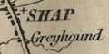
Greyhound [Shap] Shap Wells Inn Wheat Sheaf [W of Brough] Cross Keys [S of Brothers Water] |
|
|
|
||
|
lead mines
mines |
On the west side if Derwent Water, north of Manesty, is
a:-
Lead Mine |
|
|
|
||
|
slate quarries
quarries |
In the Skelwith area is:-
Flag Quarry and to the north of Ill Bell:- Slate Quarry |
|
|
|
||
| beacons |
On Thackmoor Fell is a tower symbol labelled:-
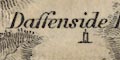
Daffenside Beacon On the hill north of Penrith is:- Beacon |
|
|
|
||
| crosses |
Near a road junction east of Kirkoswald is a cross (+)
labelled:-
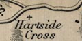
Hartside Cross |
|
|
|
||
| stones |
The:-
Dunmel Raise Stones are labelled. |
|
|
|
||
|
antiquities
stone circles |
The Castlerigg Stone Circle is labelled:-
Druids Stones |
|
|
|
||
| antiquities |
Not clearly located, near Eamont Bridge, is:-
Arthur's Round Table |
|
|
|
||
|
antiquities
roman wall |
A line drawn with fence palings marks Hadrian's Wall, from Bowness on Solway by Carlisle and eastward across Cumberland into Northumberland. |
|
|
|
||
|
antiquities
roman forts |
A roman fort is marked by a block, labelled:-
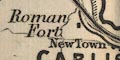
Roman Fort as west of Carlisle. |
|
Lakes Guides menu.