 Old Cumbria Gazetteer
 |
 |
|
| included in:- |
 Coniston Water Coniston Water |
|
| viewpoint, Hollin Bank N | ||
| locality:- | Hollin Bank | |
| civil parish:- | Coniston (formerly Lancashire) | |
| county:- | Cumbria | |
| locality type:- | viewpoint | |
| coordinates:- | SD32169847 (guess) | |
| 1Km square:- | SD3298 | |
| 10Km square:- | SD39 | |
|
|
||
| evidence:- | descriptive text:- West 1778 (11th edn 1821) |
|
| source data:- | Guide book, A Guide to the Lakes, by Thomas West, published by
William Pennington, Kendal, Cumbria once Westmorland, and in
London, 1778 to 1821. goto source Page 54:- "..." "At Water-head, the road to the east leads to Ambleside, eight miles; to Hawkshead, three. Ascend a steep hill surronded (sic) with" goto sourcePage 55:- "wood, and have a back view of the lake. To the north is a most awful scene of mountains, in every variety of horrid shape. Amongst them sweeps to the north a deep winding chasm, darkened by overhanging rocks, that the eye cannot pierce, nor the imagination fathom; from which turn your face to the east, and you have a view of some part of Windermere-water. ..." |
|
|
|
||
| evidence:- | old map:- Crosthwaite 1783-94 (Con) |
|
| source data:- | Map, uncoloured engraving, An Accurate Map of Coniston Lake,
scale about 3 inches to 1 mile, by Peter Crosthwaite, Keswick,
Cumberland, 1788, version published 1809.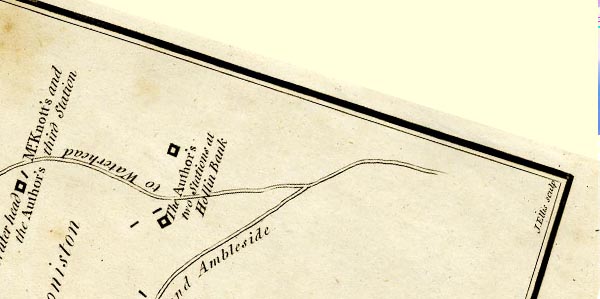 CTESD39J.jpg "The Author's two Stations at Hollin Bank" each marked by a square symbol "... are near Hollin Bank, half a Mile to the N.E. of the Head of the Lake on the road from Hawkshead to Waterhead ..." item:- JandMN : 182.5 Image © see bottom of page |
|
|
|
||
| evidence:- | old map:- Crosthwaite 1783-94 (Con) placename:- station, Coniston, Crosthwaite 2 |
|
| source data:- | Series of maps, An Accurate Map of the Matchless Lake of
Derwent, of the Grand Lake of Windermere, of the Beautiful Lake
of Ullswater, of Broadwater or Bassenthwaite Lake, of Coniston
Lake, of Buttermere, Crummock and Loweswater Lakes, and
Pocklington's Island, by Peter Crosthwaite, Kendal, Cumberland
now Cumbria, 1783 to 1794. "The Author's two Stations at Hollin Bank" two square symbols:- "... near Hollin Bank, half a mile to the N.E. of the Head of the Lake on the Road from Hawkshead to Waterhead" |
|
|
|
||
| indexing | ||
| person:- | map maker : Crosthwaite, Peter |
|
| place:- | Coniston Water | |
| date:- | 1788 |
|
| period:- | 18th century, late | |
| period:- | 1780s | |
| item:- | map; Accurate Map of Coniston Lake |
|
|
|
||
Lakes Guides menu.