 Old Cumbria Gazetteer
 |
 |
|
| Scout Scar, Underbarrow and Bradleyfield | ||
| Scout Scar | ||
| civil parish:- | Underbarrow and Bradleyfield (formerly Westmorland) | |
| civil parish:- | Helsington (formerly Westmorland) | |
| county:- | Cumbria | |
| locality type:- | rocks | |
| coordinates:- | SD48639040 (etc etc) | |
| 1Km square:- | SD4890 | |
| 10Km square:- | SD49 | |
| SummaryText:- | seems now to include the whole range of scars | |
|
|
||
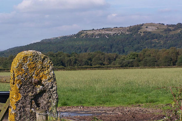 BJU89.jpg From the SW in the Lyth Valley. (taken 12.9.2005) |
||
|
|
||
| evidence:- | old map:- OS County Series (Wmd 38 11) placename:- Scout Scar |
|
| source data:- | Maps, County Series maps of Great Britain, scales 6 and 25
inches to 1 mile, published by the Ordnance Survey, Southampton,
Hampshire, from about 1863 to 1948. |
|
|
|
||
| evidence:- | old map:- Jefferys 1770 (Wmd) placename:- Underbarrow Scar |
|
| source data:- | Map, 4 sheets, The County of Westmoreland, scale 1 inch to 1
mile, surveyed 1768, and engraved and published by Thomas
Jefferys, London, 1770.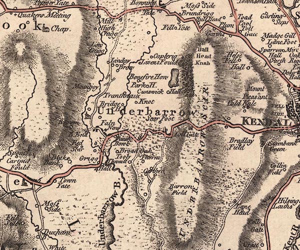 J5SD49SE.jpg "UNDERBARROW SCAR" hill hachuring; hill or mountain item:- National Library of Scotland : EME.s.47 Image © National Library of Scotland |
|
|
|
||
| evidence:- | descriptive text:- West 1778 (11th edn 1821) |
|
| source data:- | Guide book, A Guide to the Lakes, by Thomas West, published by
William Pennington, Kendal, Cumbria once Westmorland, and in
London, 1778 to 1821. goto source goto sourcePage 178, footnote:- "About a mile and a half from Kendal, on the road to Ulverston, is Scout-scar, a high rock, on which is a terrace of about a mile in length, facing the west, from which there is a most extensive and surprising view, which you come upon all at once as you approach the top, and is equal, if not superior, to most of the views in this romantic country." |
|
|
|
||
| evidence:- | old map:- West 1784 map placename:- Underbarrow Scar |
|
| source data:- | Map, hand coloured engraving, A Map of the Lakes in Cumberland,
Westmorland and Lancashire, scale about 3.5 miles to 1 inch,
engraved by Paas, 53 Holborn, London, about 1784.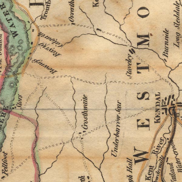 Ws02SD49.jpg item:- Armitt Library : A1221.1 Image © see bottom of page |
|
|
|
||
| evidence:- | old text:- Gents Mag item:- geology; fossil; botany; flower |
|
| source data:- | Magazine, The Gentleman's Magazine or Monthly Intelligencer or
Historical Chronicle, published by Edward Cave under the
pseudonym Sylvanus Urban, and by other publishers, London,
monthly from 1731 to 1922. goto source Gentleman's Magazine 1794 p.112 "... The West side of the Fell [Kendal Fell] is steep, frequently perpendicular; and the great quantity of limestone rubbish collected at the bottom of the precipice is covered with underwood, and has been famous since the time of Ray for a number of uncommon plants. I can add to the list already to be found in botanical works an early and undefined variety of the cynosurus coeruleus, differing in the following particulars from that noticed by Mr. Lightfoot. It grows in the dry chinks of the rocks, flowers in the beginning of April, and never exceeds six or eight inches in height. The tevite, a kind of linnet, builds its nest on the summit, either among loose stones, or under the stinted junipers, which spread their branches over the mossy surface of this barren soil, and heighten the picture of sterility by their starved appearance. The dottrel, charadius morinellus, also pays a short visit to this uninviting spot at the first coming of the swallow, in its passage from the seacoast to the interior mountains, where it spends the summer, and lingers a few days on its return to winter-quarters about the end of September." |
|
|
|
||
| evidence:- | old text:- Gents Mag 1794 |
|
| source data:- | goto source Gentleman's Magazine 1794 p.112 "principally of the bivalve kind, which are very frequently mutilated. This vast mass of calcareous matter terminates in an extensive field of the same, occupying the valley to the South, In this part it rests on an elevated ridge of the grey variety of the shistus fuscus, which is the common stone of the country to the North, and even takes place immediately on the East side of the river, where no limestone appears parallel to the hill; but the natural rock is never seen in the low grounds excepting by those who sink deep wells; for, it is buried beneath a thick covering of sand and pebbles, that forms the bed of the Kent, and extends up the declivities on both sides of it to a height far exceeding the limits of the present channel. The West side of the Fell is steep, frequently perpendicular; and the great quantity of limestone rubbish collected at the bottom of the precipice is covered with underwood, and has been famous since the time of Ray for a number of uncommon plants. I can add to the list already to be found in botanical works an early and undefined variety of the cynosurus coeruleus, differing in the following particulars from that noticed by Mr. Lightfoot. It grows in the dry chinks of the rocks, flowers in the beginning of April, and never exceeds six or eight inches in height. The tevite, a kind of linnet, builds its nest on the summit, either among loose stones, or under the stinted junipers, which spread their branches over the mossy surface of this barren soil, and heighten the picture of sterility by their starved appearance. The dottrel, charadius morinellus, also pays a short visit to this uninviting spot at the first coming of the swallow, in its passage from the seacoast to the interior mountains, where it spends the summer, and lingers a few days on its return to winter-quarters about the end of September." |
|
|
|
||
| evidence:- | old postcard:- placename:- Scout Scar |
|
| source data:- | Postcard, Reliable Series, colour printed photograph, view from Scout Scar looking
across the Lyth Valley, Westmorland, published by W R and S, mid 20th century?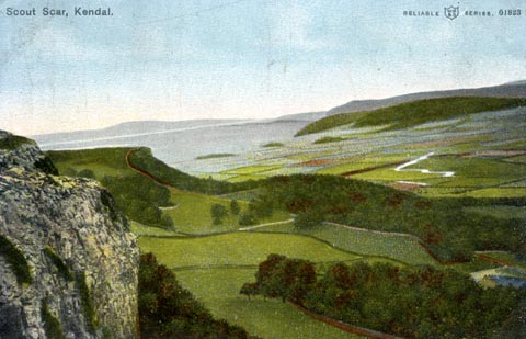 click to enlarge click to enlargePH0089.jpg printed at top:- "Scout Scar, Kendal / RELIABLE W R &S SERIES. 01823" item:- JandMN : 957 Image © see bottom of page |
|
|
|
||
| evidence:- | old print:- Bogg 1898 item:- boar; wild boar, last |
|
| source data:- | Print, engraving, Robert de Gylpin and the Last Wild Boar, Scout Scar, Underbarrow
and Bradleyfield, Westmorland, by Gilbert Foster, published by Edmund Bogg, 3 Woodhouse
Lane, and James Miles, Guildford Street, Leeds, Yorkshire, 1898.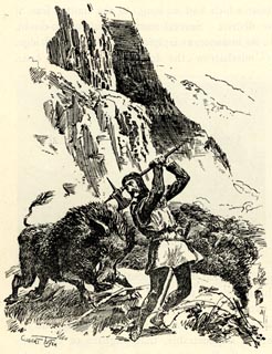 click to enlarge click to enlargeBGG188.jpg Included on p.224 of Lakeland and Ribblesdale, by Edmund Bogg; an imaginative scene. item:- JandMN : 231.88 Image © see bottom of page |
|
|
|
||
| evidence:- | old print:- Rose 1832-35 (vol.3 no.69) placename:- Scout Scar |
|
| source data:- | Print, uncoloured engraving, Scout Scar, near Kendal, Westmorland, drawn by Thomas
Allom, engraved by T H Shepherd, published by Fisher, Son and Co, London, 1835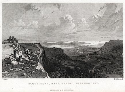 click to enlarge click to enlargePR0422.jpg Originally vol.3 no.69 in Westmorland, Cumberland, Durham and Northumberland Illustrated. printed at bottom left, right, centre:- "T. Allom. / T. H. Shepherd. / SCOUT SCAR, NEAR KENDAL, WESTMORLAND. / FISHER, SON &Co. LONDON, 1835." item:- Dove Cottage : 2008.107.415 Image © see bottom of page |
|
|
|
||
| notes:- |
The last wild boar fell to Richard Gilpin of Kentmere, late 17th century. It has |
|
| "much indammaged the country people there" |
||
|
|
||
Lakes Guides menu.