 Old Cumbria Gazetteer
 |
 |
|
||||||||||||||||||||||||
| Pillar, Ennerdale and Kinniside | ||||||||||||||||||||||||||
| Pillar | ||||||||||||||||||||||||||
| civil parish:- | Ennerdale and Kinniside (formerly Cumberland) | |||||||||||||||||||||||||
| civil parish:- | Nether Wasdale (formerly Cumberland) | |||||||||||||||||||||||||
| county:- | Cumbria | |||||||||||||||||||||||||
| locality type:- | hill | |||||||||||||||||||||||||
| coordinates:- | NY17121211 | |||||||||||||||||||||||||
| 1Km square:- | NY1712 | |||||||||||||||||||||||||
| 10Km square:- | NY11 | |||||||||||||||||||||||||
| altitude:- | 2927 feet | |||||||||||||||||||||||||
| altitude:- | 892m | |||||||||||||||||||||||||
|
|
||||||||||||||||||||||||||
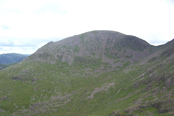
 BSU16.jpg (taken 17.5.2010) 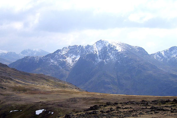 BPA52.jpg (taken 16.4.2008) |
||||||||||||||||||||||||||
|
|
||||||||||||||||||||||||||
| evidence:- | old map:- OS County Series (Cmd 74 2) placename:- Pillar |
|||||||||||||||||||||||||
| source data:- | Maps, County Series maps of Great Britain, scales 6 and 25
inches to 1 mile, published by the Ordnance Survey, Southampton,
Hampshire, from about 1863 to 1948. |
|||||||||||||||||||||||||
|
|
||||||||||||||||||||||||||
| evidence:- | old map:- Donald 1774 (Cmd) placename:- Pillar |
|||||||||||||||||||||||||
| source data:- | Map, hand coloured engraving, 3x2 sheets, The County of Cumberland, scale about 1
inch to 1 mile, by Thomas Donald, engraved and published by Joseph Hodskinson, 29
Arundel Street, Strand, London, 1774.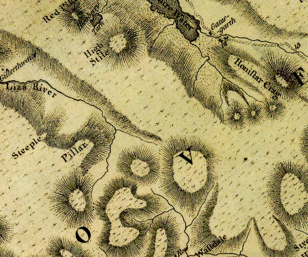 D4NY11SE.jpg "Pillar" hill hachuring; a hill or mountain item:- Carlisle Library : Map 2 Image © Carlisle Library |
|||||||||||||||||||||||||
|
|
||||||||||||||||||||||||||
| evidence:- | descriptive text:- West 1778 (11th edn 1821) |
|||||||||||||||||||||||||
| source data:- | Guide book, A Guide to the Lakes, by Thomas West, published by
William Pennington, Kendal, Cumbria once Westmorland, and in
London, 1778 to 1821. goto source goto sourceAccount of Ennerdale, late 18th century Page 293:- "..." "... As he approaches the vale of Ennerdale, ... he will find the rugged scenery of the country gradually refining; and as he winds round the foot of the Pillar, he will discover a vista, which cannot fail to strike the most indifferent observer with astonishment and pleasure." "The mountains which serve to heighten this scene, and enhance its surprise, are Sty-head, Honister-crag, Wastdale, the Pillar, and Red-pike. ..." |
|||||||||||||||||||||||||
|
|
||||||||||||||||||||||||||
| evidence:- | old drawing:- Green 1790s-1820s placename:- Pillar, The |
|||||||||||||||||||||||||
| source data:- | Drawing, pencil, Pillar, Ennerdale and Kinniside, Cumberland, by William Green, Ambleside,
Westmorland, 1800s-10s?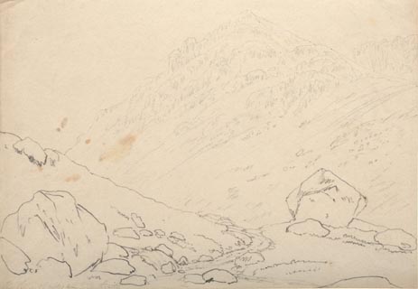 click to enlarge click to enlargePR1736.jpg ms, pencil at lower left:- "The Pillar 1½miles from Gillerthwaite" item:- Dove Cottage : 1994.118.2 Image © see bottom of page |
|||||||||||||||||||||||||
|
|
||||||||||||||||||||||||||
| evidence:- | old map:- Otley 1818 placename:- Pillar |
|||||||||||||||||||||||||
| source data:- | Map, uncoloured engraving, The District of the Lakes,
Cumberland, Westmorland, and Lancashire, scale about 4 miles to
1 inch, by Jonathan Otley, 1818, engraved by J and G Menzies,
Edinburgh, Scotland, published by Jonathan Otley, Keswick,
Cumberland, et al, 1833.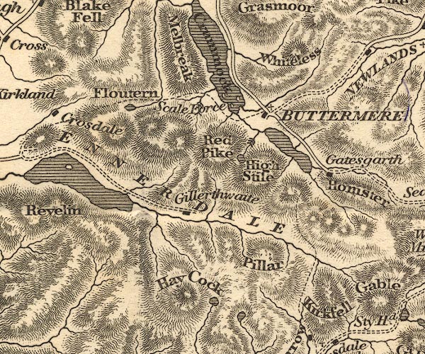 OT02NY11.jpg item:- JandMN : 48.1 Image © see bottom of page |
|||||||||||||||||||||||||
|
|
||||||||||||||||||||||||||
| evidence:- | outline view:- Otley 1823 (4th edn 1830) placename:- Pillar Fell |
|||||||||||||||||||||||||
| source data:- | Print, engraving, outline view, Some of the Western Mountains as seen from Helvellyn,
published by Jonathan Otley, Keswick, Cumberland et al, 1830.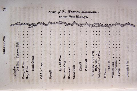 click to enlarge click to enlargeO75E02.jpg p.57 in A Concise Description of the English Lakes, by Jonathan Otley, 4th edition, 1830. "Some of the Western Mountains: / as seen from Helvellyn." "Wetherlam / Old Man - Coniston Fell / Carrs, or Scars / Gray Friar / Black Combe / Crinkle Crags / Bowfell / Scawfell Pike / Great-end Crag / Glaramara / Great Gable / Kirkfell / Pillar Fell / Honister and High Crag / High Stile / Dalehead and Red Pike / Robinson / Blake Fell / Witeless Pike / Grasmoor / Ill Crags / Grisedale Pike" item:- Armitt Library : A1175.3 Image © see bottom of page |
|||||||||||||||||||||||||
|
|
||||||||||||||||||||||||||
| evidence:- | outline view:- Otley 1823 (4th edn 1830) placename:- Pillar, The |
|||||||||||||||||||||||||
| source data:- | Print, engraving, outline view, Mountains of Ennerdale as seen from Kirkland, published
by Jonathan Otley, Keswick, Cumberland et al, 1830.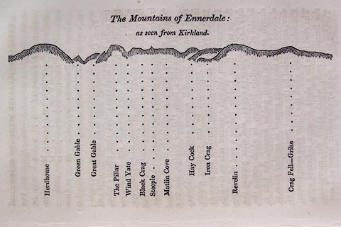 click to enlarge click to enlargeO75E09.jpg p.131 in A Concise Description of the English Lakes, by Jonathan Otley, 4th edition, 1830. "The Mountains of Ennerdale: / as seen from Kirkland." "Herdhouse / Green Gable / Great Gable / The Pillar / Wind Yate / Black Crag / Steeple / Matlin Cove / Hay Cock / Iron Crag / Revelin / Crag Fell - Grike" item:- Armitt Library : A1175.9 Image © see bottom of page |
|||||||||||||||||||||||||
|
|
||||||||||||||||||||||||||
| evidence:- | outline view:- Otley 1823 (8th edn 1849) placename:- Pillar |
|||||||||||||||||||||||||
| source data:- | Engraving, outline view of mountains, Ennerdale from a Field near Kirkland and Salter,
drawn by T Binns, engraved by O Jewitt, opposite p.20 of A Descriptive Guide of the
English Lakes, by Jonathan Otley, 8th edition, 1849.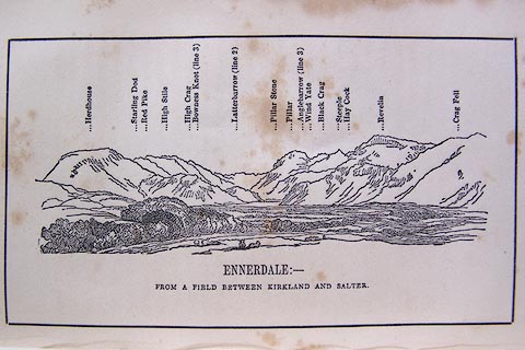 click to enlarge click to enlargeO80E11.jpg item:- Armitt Library : A1180.12 Image © see bottom of page |
|||||||||||||||||||||||||
|
|
||||||||||||||||||||||||||
| evidence:- | outline view:- Otley 1823 (8th edn 1849) placename:- Pillar |
|||||||||||||||||||||||||
| source data:- | Engraving, outline view of mountains, A Group of Mountains seen from Helvellyn, looking
towards the South West, drawn by T Binns, engraved by O Jewitt, opposite p.50 of A
Descriptive Guide of the English Lakes, by Jonathan Otley, 8th edition, 1849.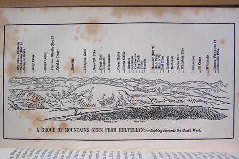 click to enlarge click to enlargeO80E17.jpg item:- Armitt Library : A1180.18 Image © see bottom of page |
|||||||||||||||||||||||||
|
|
||||||||||||||||||||||||||
| evidence:- | outline view:- Otley 1823 (5th edn 1834) |
|||||||||||||||||||||||||
| source data:- | Print, woodcut outline view, The Mountains of Ennerdale, by
Jonathan Otley, Keswick, Cumberland, 1830.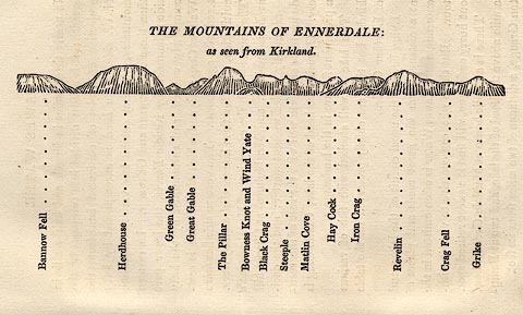 click to enlarge click to enlargeOT2E06.jpg Printed on p.27 of A Concise Description of the English Lakes, by Jonathan Otley, 5th edition, 1834. "THE MOUNTAINS OF ENNERDALE: as seen from Kirkland." "Bannow Fell / Herdhouse / Green Gable / Great Gable / The Pillar / Bowness Knot and Wind Yate / Black Crag / Steeple / Matlin Cove / Hay Cock / Iron Crag / Revelin / Crag Fell / Grike" item:- JandMN : 48.7 Image © see bottom of page |
|||||||||||||||||||||||||
|
|
||||||||||||||||||||||||||
| evidence:- | outline view:- Otley 1823 (5th edn 1834) placename:- Pillar Fell |
|||||||||||||||||||||||||
| source data:- | Print, woodcut outline view, A Group of Mountains, seen from
Helvellyn, by Jonathan Otley, Keswick, Cumberland, 1830.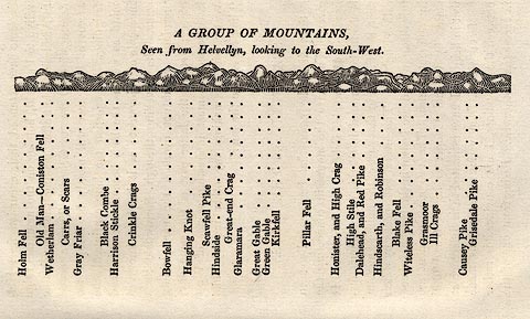 click to enlarge click to enlargeOT2E09.jpg Printed on p.63 of A Concise Description of the English Lakes, by Jonathan Otley, 5th edition, 1834. "A GROUP OF MOUNTAINS, Seen from Helvellyn, looking to the South-West." "Holm Fell / Old Man - Coniston Fell / Wetherlam / Carrs, or Scars / Gray Friar / Black Combe / Harrison Stickle / Crinkle Crags / Bowfell / Hanging Knot / Scawfell Pike / Hindside / Great-end Crag / Glaramara / Great Gable / Green Gable / Kirkfell / Pillar Fell / Honister, and High Crag / High Stile / Dalehead, and Red Pike / Hindscarth, and Robinson / Blake Fell / Witeless Pike / Grasmoor / Ill Crags / Causey Pike / Grisedale Pike" item:- JandMN : 48.10 Image © see bottom of page |
|||||||||||||||||||||||||
|
|
||||||||||||||||||||||||||
| evidence:- | descriptive text:- Otley 1823 (5th edn 1834) placename:- Pillar, The placename:- Pillar Fell item:- geology; greenstone; Pillar Stone |
|||||||||||||||||||||||||
| source data:- | Guide book, A Concise Description of the English Lakes, the
mountains in their vicinity, and the roads by which they may be
visited, with remarks on the mineralogy and geology of the
district, by Jonathan Otley, published by the author, Keswick,
Cumberland now Cumbria, by J Richardson, London, and by Arthur
Foster, Kirkby Lonsdale, Cumbria, 1823; published 1823-49,
latterly as the Descriptive Guide to the English Lakes. goto source Page 70:- "THE PILLAR" "- A mountain rivalling the Gable in height - is situated between the vale of Ennerdale and that branch of Wasdale-head called Mosedale. It presents towards Ennerdale one of the grandest rocky" goto sourcePage 71:- "fronts anywhere to be met with; and has derived its name from a projecting rock on this side; which was originally called the Pillar Stone, and had been considered as inaccessible, till an adventurous shepherd reached its summit in 1826. The rock is a kind of greenstone, more porphyritic than that of Gable." |
|||||||||||||||||||||||||
|
|
||||||||||||||||||||||||||
| evidence:- | descriptive text:- Ford 1839 (3rd edn 1843) placename:- Pillar item:- altitude, Pillar |
|||||||||||||||||||||||||
| source data:- | Guide book, A Description of Scenery in the Lake District, by
Rev William Ford, published by Charles Thurnam, Carlisle, by W
Edwards, 12 Ave Maria Lane, Charles Tilt, Fleet Street, William
Smith, 113 Fleet Street, London, by Currie and Bowman,
Newcastle, by Bancks and Co, Manchester, by Oliver and Boyd,
Edinburgh, and by Sinclair, Dumfries, 1839. goto source Page 178:- "ELEVATION OF THE MOUNTAINS," "ACCORDING TO DIFFERENT AUTHORITIES."
|
|||||||||||||||||||||||||
|
|
||||||||||||||||||||||||||
| evidence:- | old map:- Ford 1839 map placename:- Pillar |
|||||||||||||||||||||||||
| source data:- | Map, uncoloured engraving, Map of the Lake District of
Cumberland, Westmoreland and Lancashire, scale about 3.5 miles
to 1 inch, published by Charles Thurnam, Carlisle, and by R
Groombridge, 5 Paternoster Row, London, 3rd edn 1843.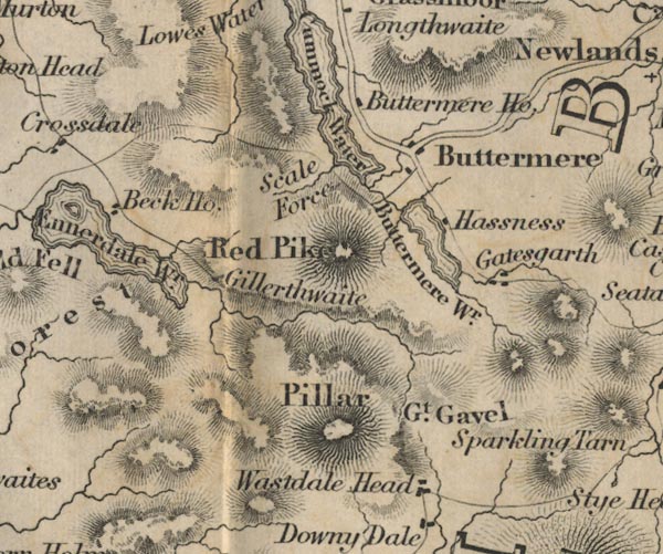 FD02NY11.jpg "Pillar" Hill hachuring. item:- JandMN : 100.1 Image © see bottom of page |
|||||||||||||||||||||||||
|
|
||||||||||||||||||||||||||
| evidence:- | old map:- Garnett 1850s-60s H placename:- Pillar |
|||||||||||||||||||||||||
| source data:- | Map of the English Lakes, in Cumberland, Westmorland and
Lancashire, scale about 3.5 miles to 1 inch, published by John
Garnett, Windermere, Westmorland, 1850s-60s.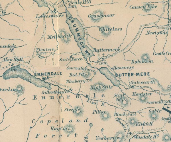 GAR2NY11.jpg "Pillar" hill hachuring item:- JandMN : 82.1 Image © see bottom of page |
|||||||||||||||||||||||||
|
|
||||||||||||||||||||||||||
| evidence:- | old print:- Pyne 1853 |
|||||||||||||||||||||||||
| source data:- | Print, tinted lithograph, Ennerdale Lake, Cumberland, by James Baker Pyne, engraved
by W Gauci, published by Thomas Agnew and Sons, Manchester, Lancashire, 1853.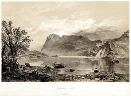 click to enlarge click to enlargePYN205.jpg "PAINTED BY J. B. PYNE. / W. GAUCI LITH. / MANCHESTER, PUBLISHED BY THOMAS AGNEW & SONS, 1853. / Ennerdale Lake / M & N HANHART IMPT." item:- Armitt Library : A6678.6 Image © see bottom of page |
|||||||||||||||||||||||||
|
|
||||||||||||||||||||||||||
| evidence:- | old print:- Pyne 1853 |
|||||||||||||||||||||||||
| source data:- | Print, coloured lithograph, Ennerdale Lake, Cumberland, by James Baker Pyne, engraved
by W Gauci, published by Thomas Agnew and Sons, Manchester, Lancashire, 1853.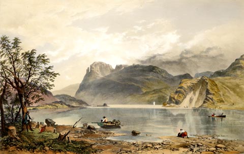 click to enlarge click to enlargePYN405.jpg item:- Armitt Library : A6677.6 Image © see bottom of page |
|||||||||||||||||||||||||
|
|
||||||||||||||||||||||||||
| evidence:- | old text:- Martineau 1855 item:- altitude, Pillar |
|||||||||||||||||||||||||
| source data:- | Guide book, A Complete Guide to the English Lakes, by Harriet
Martineau, published by John Garnett, Windermere, Westmorland,
and by Whittaker and Co, London, 1855; published 1855-76. goto source Page 161:- "... The Pillar is 2,893 feet high, and inaccessible, from its craggy and precipitous character. ..." |
|||||||||||||||||||||||||
|
|
||||||||||||||||||||||||||
| evidence:- | old text:- Martineau 1855 item:- altitude, Pillar |
|||||||||||||||||||||||||
| source data:- | Guide book, A Complete Guide to the English Lakes, by Harriet
Martineau, published by John Garnett, Windermere, Westmorland,
and by Whittaker and Co, London, 1855; published 1855-76. goto source Page 179:- "A TABLE OF THE HEIGHTS OF MOUNTAINS IN THE COUNTIES OF CUMBERLAND, WESTMORLAND, AND LANCASHIRE." "No. : Names of Mountains. : Counties. : Height in Feet above the Sea Level." "9 : Pillar : Cumberland : 2893" |
|||||||||||||||||||||||||
|
|
||||||||||||||||||||||||||
| evidence:- | text:- Mason 1907 (edn 1930) |
|||||||||||||||||||||||||
| source data:- | Text book, The Ambleside Geography Books bk.III, The Counties of
England, by Charlotte M Mason, published by Kegan Paul, Trench,
Trubner and Co, Broadway House, 68-74 Carter Lane, and the
Parents' Educational Union Office, 26 Victoria Street, London,
edn 1930. MSN1P023.txt Page 23:- "..." "... to know that ... Pillar is rather like a pillar; ... and that the Pikes - Sca Fell Pikes and Langdale Pikes - are pairs of giants with rounded heads, that you may always recognise." |
|||||||||||||||||||||||||
|
|
||||||||||||||||||||||||||
| evidence:- | outline view:- Seascale 1920s-30s placename:- Pillar Mountain |
|||||||||||||||||||||||||
| source data:- | Print, uncoloured engraving, outline view, mountains from Seascale, published by Edward
Burrow and Son, Cheltenham, Gloucestershire, 1920s-30s.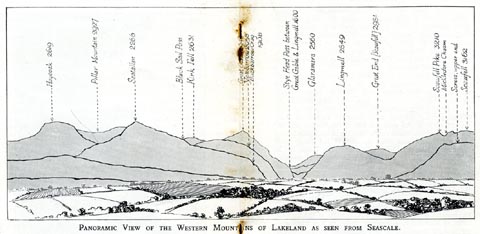 click to enlarge click to enlargeSES113.jpg "PANORAMIC VIEW OF THE WESTERN MOUNTAINS OF LAKELAND AS SEEN FROM SEASCALE." "... Pillar Mountain 2927 ..." item:- JandMN : 1079.13 Image © see bottom of page |
|||||||||||||||||||||||||
|
|
||||||||||||||||||||||||||
| evidence:- | outline view:- Jenkinson 1875 placename:- Pillar |
|||||||||||||||||||||||||
| source data:- | Print, lithograph, outline view, Panoramic Sketches from Helvellyn, Westmorland, by
Edwin A Pettitt, London, published by Edward Stanford, 55 Charing Cross, London, 1875. click to enlarge click to enlargeJk01E1.jpg "... Pillar ..." item:- JandMN : 28.5 Image © see bottom of page |
|||||||||||||||||||||||||
|
|
||||||||||||||||||||||||||
| evidence:- | outline view:- Jenkinson 1875 placename:- Pillar |
|||||||||||||||||||||||||
| source data:- | Print, lithograph, outline view, Panoramic Sketches from Skiddaw, Cumberland, by Edwin
A Pettitt, London, published by Edward Stanford, 55 Charing Cross, London, 1875. click to enlarge click to enlargeJk01E2.jpg "... Pillar ..." item:- JandMN : 28.8 Image © see bottom of page |
|||||||||||||||||||||||||
|
|
||||||||||||||||||||||||||
| evidence:- | outline view:- Jenkinson 1875 placename:- Pillar |
|||||||||||||||||||||||||
| source data:- | Print, lithograph, outline view, Panoramic Sketches from Scawfell Pike, Cumberland,
by Edwin A Pettitt, London, published by Edward Stanford, 55 Charing Cross, London,
1875. click to enlarge click to enlargeJk01E3.jpg "... Pillar ..." item:- JandMN : 28.9 Image © see bottom of page |
|||||||||||||||||||||||||
|
|
||||||||||||||||||||||||||
| evidence:- | outline view:- Matthew 1866 placename:- Piller |
|||||||||||||||||||||||||
| source data:- | Print, engraving, outline view, Ennerdale, Cumberland, published by J Richardson,
Highgate, Kendal, Westmorland, 1866.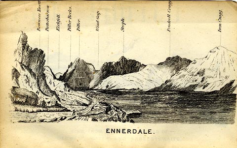 click to enlarge click to enlargeMW1E04.jpg Tipped in before p.1 of The English Lakes, Peaks and Passes, from Kendal to Keswick, by George King Matthew. printed at bottom:- "ENNERDALE" printed at caption to mountains:- "... Piller. ..." item:- Armitt Library : A1168.4 Image © see bottom of page |
|||||||||||||||||||||||||
|
|
||||||||||||||||||||||||||
| evidence:- | old print:- Pyne 1853 |
|||||||||||||||||||||||||
| source data:- | Drawn by James Barker Pyne, 1848-1853, lithographed by T Picken, 1859.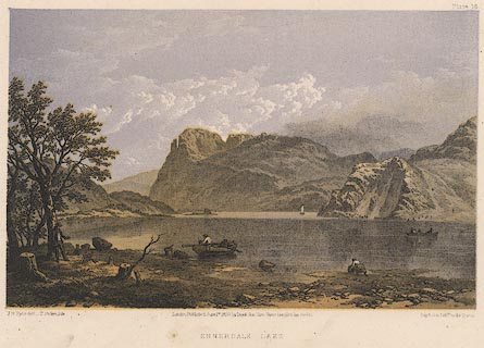 click to enlarge click to enlargePY16.jpg "Ennerdale Lake" item:- JandMN : 97.15 Image © see bottom of page |
|||||||||||||||||||||||||
|
|
||||||||||||||||||||||||||
| evidence:- | outline view:- Tattersall 1836 placename:- Pillar, The |
|||||||||||||||||||||||||
| source data:- | Print, engraving, Ennerdale Lake, from the North East, Cumberland, drawn by George
Tattersall, engraved by W F Topham, published by Sherwood and Co, Paternoster Row,
London, about 1836.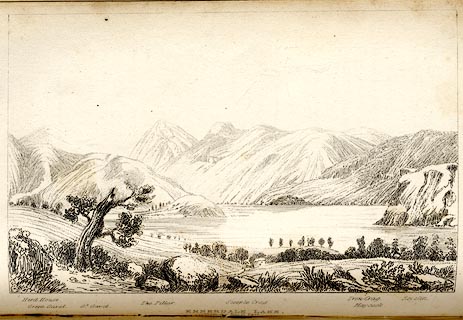 click to enlarge click to enlargeTAT133.jpg The print is captioned with mountain names and acts as an outline view. Tipped in opposite p.83 of The Lakes of England, by George Tattersall. printed at bottom:- "ENNERDALE LAKE, / from the North East." printed at bottom left to right:- "Herd House. / Green Gavel. / Gt. Gavel. / The Pillar. / Steeple Crag. / Iron Crag. / Haycock. / Revelin." item:- Armitt Library : A1204.34 Image © see bottom of page |
|||||||||||||||||||||||||
|
|
||||||||||||||||||||||||||
| evidence:- | outline view:- Tattersall 1836 (version 1869) placename:- Pillar, The |
|||||||||||||||||||||||||
| source data:- | Print, hand coloured, Ennerdale Lake, from the North East, Cumberland, drawn by George
Tattersall, 1836, engraved by W F Topham, published by T J Allman, 463 Oxford Street,
London, 1869.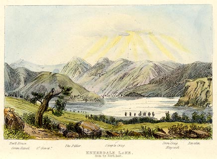 click to enlarge click to enlargeTAT215.jpg Included in The Lakes of England, by W F Topham. printed at bottom:- "ENNERDALE LAKE, / from the North East." printed at bottom:- "Herd House. / Green Gavel. / Gt. Gavel. / The Pillar. / Steeple Crag. / Iron Crag. / Haycock. / Revelin." item:- Armitt Library : A1067.15 Image © see bottom of page |
|||||||||||||||||||||||||
|
|
||||||||||||||||||||||||||
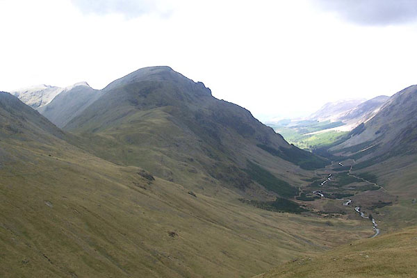
 BTE94.jpg (taken 13.7.2010) 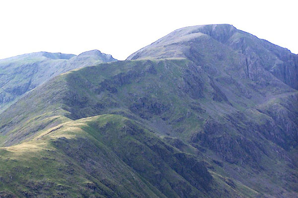 BMR62.jpg From about Brandreth. (taken 22.9.2006) 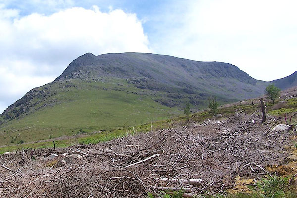 BQX25.jpg White Pike on the left, Windgap on the right. (taken 25.6.2009) 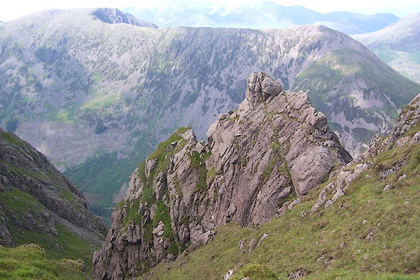 BQX36.jpg Rocks; High Stile and High Crag behind. (taken 25.6.2009) 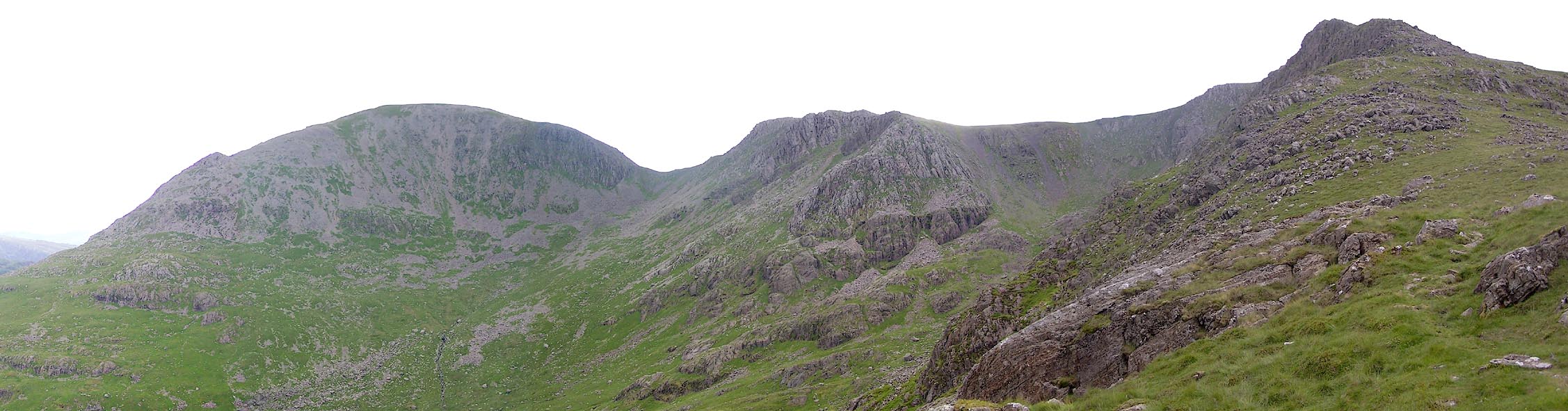 Click to enlarge BTE95.jpg Pillar, Wind Gap, Scoat Fell, Steeple, Black Crag. (taken 13.7.2010) 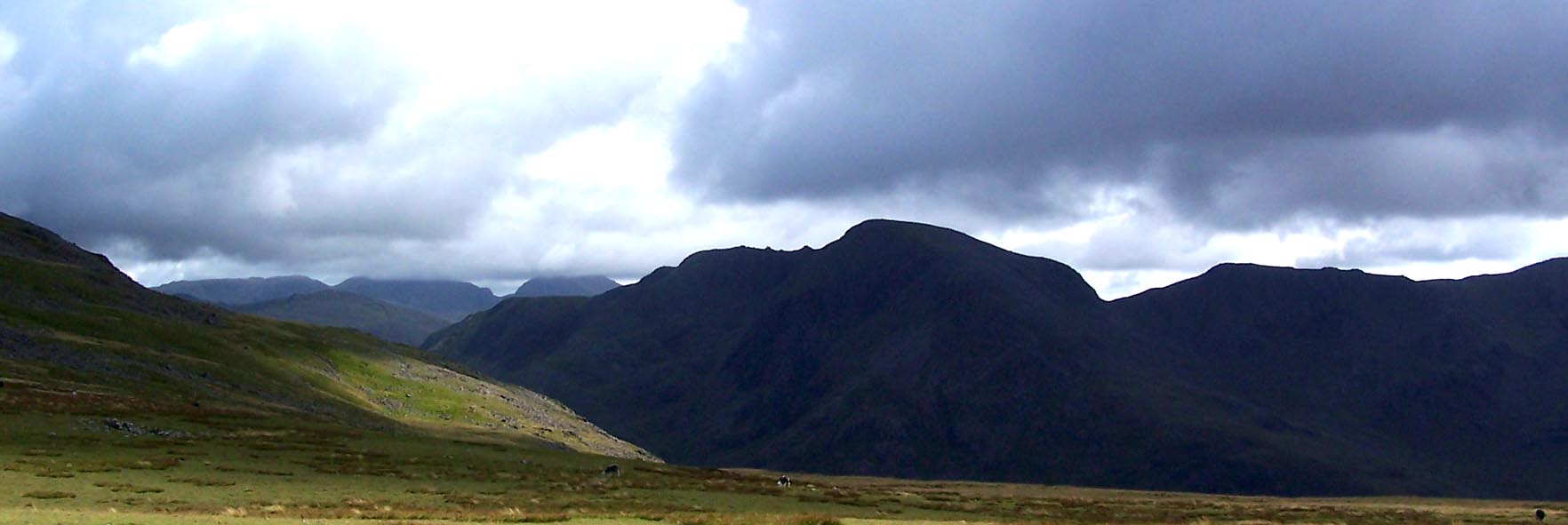 Click to enlarge BVH07.jpg (taken 17.8.2011) 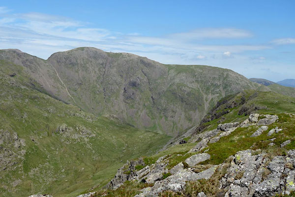 BYO66.jpg (taken 18.6.2013) 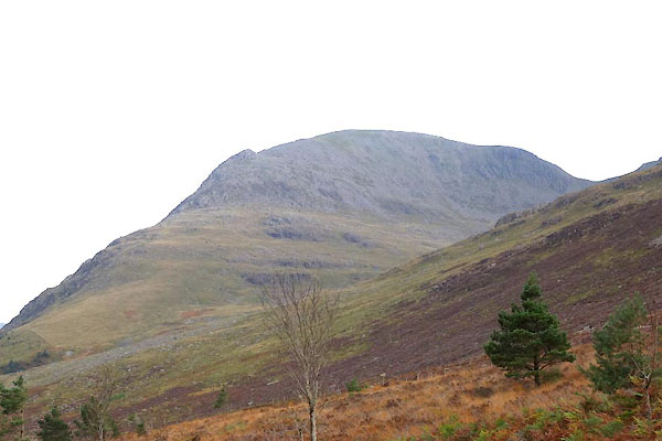 CEF91.jpg From NW. (taken 27.10.2015) 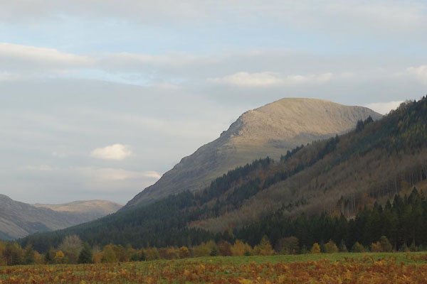 CEG03.jpg (taken 27.10.2015) |
||||||||||||||||||||||||||
|
|
||||||||||||||||||||||||||
| hearsay:- |
A Brocken Spectre was observed here by H Williamson of Routen, Ennerdale:- |
|||||||||||||||||||||||||
| "It would be about 8 o'clock one morning, during the late spring or early summer, ...
The valley was full of mist with the mountain tops showing through it. Overhaed was
blue sky and brilliant sunshine. I was collecting sheep near to the top of the Pillar
mountain and I walked out on an arm that sticks out about four to five hundred yards
on the north-east side of the Pillar rock. I was now in such a position that the sun
threw my shadow on to the mist below me where it appeared inside a complete circle
of rainbow with my feet touching the bottom and my head the top." |
||||||||||||||||||||||||||
|
|
||||||||||||||||||||||||||
Lakes Guides menu.