 Old Cumbria Gazetteer
 |
 |
|
| Pavey Ark, Lakes | ||
| Pavey Ark | ||
| locality:- | Great Langdale | |
| locality:- | hill | |
| locality:- | rocks | |
| civil parish:- | Lakes (formerly Westmorland) | |
| county:- | Cumbria | |
| coordinates:- | NY28470791 (etc) | |
| 1Km square:- | NY2807 | |
| 10Km square:- | NY20 | |
|
|
||
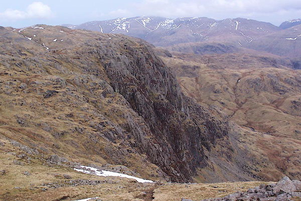 BSI99.jpg (taken 23.3.2010) 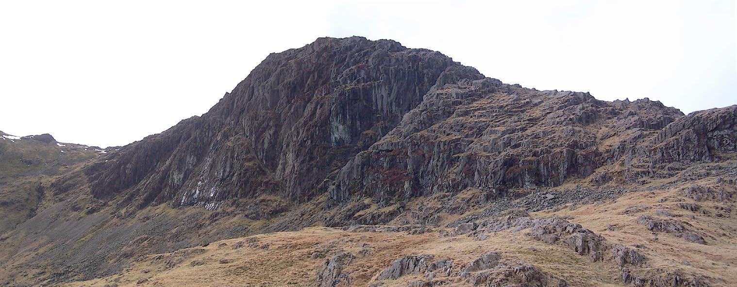 Click to enlarge BSJ01.jpg (taken 23.3.2010) |
||
|
|
||
| evidence:- | old map:- OS County Series (Wmd 18 14) placename:- Pavey Ark |
|
| source data:- | Maps, County Series maps of Great Britain, scales 6 and 25
inches to 1 mile, published by the Ordnance Survey, Southampton,
Hampshire, from about 1863 to 1948. |
|
|
|
||
| evidence:- | descriptive text:- West 1778 (11th edn 1821) |
|
| source data:- | Guide book, A Guide to the Lakes, by Thomas West, published by
William Pennington, Kendal, Cumbria once Westmorland, and in
London, 1778 to 1821. goto source goto source goto source goto sourcePage 104:- "... Pavey-ark is a hanging rock 600 feet in height, and under it is Stickle-tarn, ..." |
|
|
|
||
| evidence:- | outline view:- Otley 1823 (4th edn 1830) placename:- Paveyark |
|
| source data:- | Print, engraving, outline view, Mountains of Coniston, Langdale, &c. as they appear
from the road between Troutbeck Bridge and Bowness, published by Jonathan Otley, Keswick,
Cumberland et al, 1830.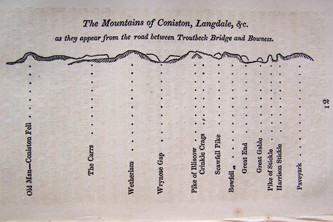 click to enlarge click to enlargeO75E04.jpg p.97 in A Concise Description of the English Lakes, by Jonathan Otley, 4th edition, 1830. "The Mountains of Coniston, Langdale, &c. / as they appear from the road between Troutbeck Bridge and Bowness." "Old Man - Coniston Fell / The Carrs / Wetherlam / Wrynose Gap / Pike of Bliscow / Crinkle Crags / Scawfell Pike / Bowfell / Great End / Great Gable / Pike of Stickle / Harrison Stickle / Paveyark" item:- Armitt Library : A1175.4 Image © see bottom of page |
|
|
|
||
| evidence:- | outline view:- Otley 1823 (8th edn 1849) placename:- Paveyark |
|
| source data:- | Engraving, outline view of mountains, Windermere looking towards the West from the
Road between Troutbeck and Bowness, drawn by T Binns, engraved by O Jewitt, opposite
p.4 of A Descriptive Guide of the English Lakes, by Jonathan Otley, 8th edition, 1849.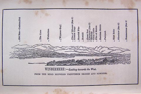 click to enlarge click to enlargeO80E03.jpg item:- Armitt Library : A1180.4 Image © see bottom of page |
|
|
|
||
| evidence:- | outline view:- Otley 1823 (5th edn 1834) |
|
| source data:- | Print, woodcut outline view, The Mountains of Coniston, Langdale, Etc, by Jonathan
Otley, Keswick, Cumberland, 1830.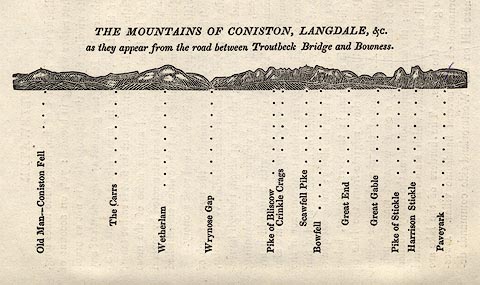 click to enlarge click to enlargeOT2E01.jpg Printed on p.7 of A Concise Description of the English Lakes, by Jonathan Otley, 5th edition, 1834. "THE MOUNTAINS OF CONISTON, LANGDALE, &c. as they appear from the road between Troutbeck Bridge and Bowness." Mountains in the view are listed:- "Old Man - Coniston Fell / The Carrs / Wetherlam / Wrynose Gap / Pike of Bliscow / Crinkle Crags / Scawfell Pike / Bowfell / Great End / Great Gable / Pike of Stickle / Harrison Stickle / Paveyark" item:- JandMN : 48.2 Image © see bottom of page |
|
|
|
||
| evidence:- | descriptive text:- Otley 1823 (5th edn 1834) |
|
| source data:- | Guide book, A Concise Description of the English Lakes, the
mountains in their vicinity, and the roads by which they may be
visited, with remarks on the mineralogy and geology of the
district, by Jonathan Otley, published by the author, Keswick,
Cumberland now Cumbria, by J Richardson, London, and by Arthur
Foster, Kirkby Lonsdale, Cumbria, 1823; published 1823-49,
latterly as the Descriptive Guide to the English Lakes. goto source Page 33:- "... Pavey-ark, a huge rock in connection with Langdale Pikes ..." |
|
|
|
||
| evidence:- | descriptive text:- Ford 1839 (3rd edn 1843) placename:- Pavey Ark |
|
| source data:- | Guide book, A Description of Scenery in the Lake District, by
Rev William Ford, published by Charles Thurnam, Carlisle, by W
Edwards, 12 Ave Maria Lane, Charles Tilt, Fleet Street, William
Smith, 113 Fleet Street, London, by Currie and Bowman,
Newcastle, by Bancks and Co, Manchester, by Oliver and Boyd,
Edinburgh, and by Sinclair, Dumfries, 1839. goto source Page 38:- "..." "Stickle Tarn ... reflecting in its calm surface the dark and towering crags of Pavey Ark, which rise from its brink, and are perhaps the most magnificent range of rocks in the country: a good point to view them from is the outlet of the lake." |
|
|
|
||
| evidence:- | outline view:- Martineau 1855 placename:- Paveyark |
|
| source data:- | Print, engraving, outline view, Mountains on the West Side of Windermere, drawn by
L Aspland, engraved by W Banks, Edinburgh, published by John Garnett, Windermere,
Westmorland, and by Whittaker and Co, London, 1855.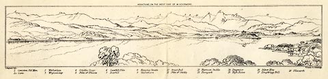 click to enlarge click to enlargeMNU102.jpg Folded in opposite p.7 in A Complete Guide to the English Lakes, by Harriet Martineau. "MOUNTAINS ON THE WEST SIDE OF WINDERMERE" "L Aspland Delt. / W Banks Sc Edinburgh." The view is captioned, numbers referring to mountains in the image:- "1 Coniston Old Man 1a Carrs 2 Wetherlam 3 Wrynose Gap 4 Crinkle Crags 5 Pike of Bliscow 6 Scawfell Pike 7 Bowfell 8 Hanging Knotts 9 Glaramara 10 Great End 11 Pike of Stickle 12 Harrison Stickle 13 Paveyark 14 Lingmoor 15 High Raise 16 Silver How 17 Loughrigg Fell 18 Ullscarth" item:- Armitt Library : A1159.2 Image © see bottom of page |
|
|
|
||
| evidence:- | outline view:- Martineau 1855 placename:- Pavey Ark |
|
| source data:- | Print, engraving, outline view, Mountains seen a little beyond Rydal Mount, drawn
by L Aspland, engraved by W Banks, Edinburgh, published by John Garnett, Windermere,
Westmorland, and by Whittaker and Co, London, 1855.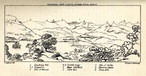 click to enlarge click to enlargeMNU109.jpg Opposite p.64 in A Complete Guide to the English Lakes, by Harriet Martineau. "MOUNTAINS SEEN A LITTLE BEYOND RYDAL MOUNT." "L Aspland Delt. / W Banks Sc Edinr." The view is captioned, numbers referring to mountains in the image:- "1 Loughrigg Fell, 2 Lingmoor, 3 Pike of Bliscow, 4 Crinkle Crags, 5 Meg's Gill Head, 6 Silver How, 7 Pike of Stickle, 8 Harrison Stickle, 9 Pavey Ark" item:- Armitt Library : A1159.9 Image © see bottom of page |
|
|
|
||
| evidence:- | old photograph:- Payn 1867 placename:- Pavey Ark |
|
| source data:- | Photograph, sepia, Stickle Tarn and Pavey Ark, Westmorland, by Garnett and Sproat,
published by J Garnett, Windermere, Westmorland, 1867.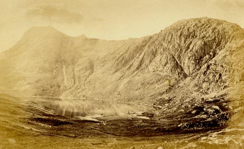 click to enlarge click to enlargePN0325.jpg Tipped in opposite p.48 of The Lakes in Sunshine, text by James Payn. printed at bottom:- "STICKLE TARN AND PAVEY ARK." item:- Fell and Rock Climbing Club : 184.25 Image © see bottom of page |
|
|
|
||
| evidence:- | old photograph:- Bell 1880s-1940s |
|
| source data:- | Photograph, black and white, Stickle Tarn and Pavey Ark, Great Langdale, Westmorland,
by Herbert Bell, photographer, Ambleside, Westmorland, 1890s.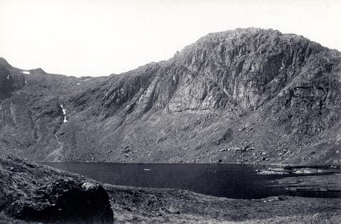 click to enlarge click to enlargeHB0643.jpg stamped on reverse:- "HERBERT BELL / Photographer / AMBLESIDE" item:- Armitt Library : ALPS306 Image © see bottom of page |
|
|
|
||
| evidence:- | outline view:- Black 1856 (23rd edn 1900) placename:- Paveyark |
|
| source data:- | Print, lithograph, Outline Views, Windermere - Mountains as seen from the North End
of Belle Isle, Windermere, and Mountains as seen from Biscay How, Bowness, by J Flintoft,
Keswick, Cumberland, engraved by R Mason, Edinburgh, Lothian, about 1900.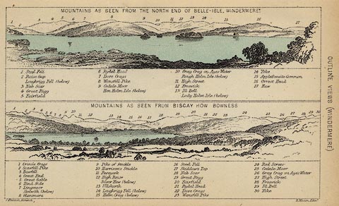 click to enlarge click to enlargeBC08E1.jpg "... 11 Paveyark ..." item:- JandMN : 37.4 Image © see bottom of page |
|
|
|
||
| evidence:- | outline view:- Black 1841 (3rd edn 1846) placename:- Paveyark |
|
| source data:- | Print, engraving, outline view, Mountains as seen from the North End of Belle Isle,
Windermere, and Mountains as seen from Bisket How, Bowness, by J Flintoft, Keswick,
Cumberland, engraved by R Mason, Edinburgh, about 1844.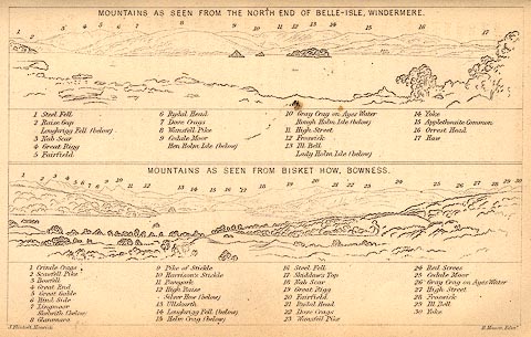 click to enlarge click to enlargeBC02E1.jpg "... 11 Paveyark ..." item:- JandMN : 32.3 Image © see bottom of page |
|
|
|
||
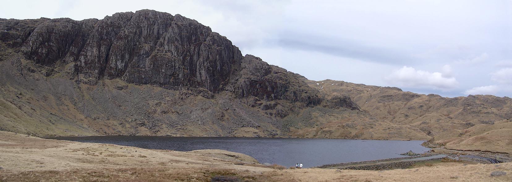 Click to enlarge BSJ02.jpg (taken 23.3.2010) 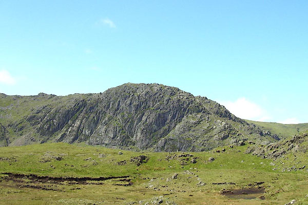 BNR32.jpg (taken 22.5.2007) |
||
|
|
||
| hearsay:- |
Captain Joseph Budworth, guided by 15 year old Paul Postlethwaite, climbed Pavey Ark,
7 Novermber 1797. The captain had lost an arm at the Seige of Gibraltar, 1779-82.
He became crag fast on:- |
|
| "a sward nearly perpendicular, and of immoderate height" |
||
| He tied a handkerchief over one eye, so that he couldn't look down, and held out his
walking stick for Paul to lead him down. |
||
|
|
||
Lakes Guides menu.